مطار القدس الدولي
Jerusalem International Airport נמל התעופה ירושלים مطار القدس الدولي | |||||||||||
|---|---|---|---|---|---|---|---|---|---|---|---|
 Atarot Airport, 1969 | |||||||||||
| الملخص | |||||||||||
| نوع المطار | Military (and formerly: joint Public) | ||||||||||
| المشغل | القوات المسلحة الإسرائيلية | ||||||||||
| الموقع | القدس | ||||||||||
| افتـُتـِح | 1920 | ||||||||||
| أُغلـِق | أكتوبر 2000 (closed to civilian traffic)[1] | ||||||||||
| المنسوب AMSL | 2,485 ft / 757 m | ||||||||||
| الإحداثيات | 31°51′53″N 35°13′09″E / 31.86472°N 35.21917°E | ||||||||||
| Maps | |||||||||||
 مدارج مطار القدس | |||||||||||
 LLJR موقع مطار القدس | |||||||||||
| Runways | |||||||||||
| |||||||||||
مطار القدس الدولي أو كما تشيع تسميته مطار قلنديا، يقع على أراضي محافظة القدس تحديداً في بلدة قلنديا على طريق (القدس - رام الله). يعتبر المطار أقرب إلى رام الله منه إلى مدينة القدس.[2] أنشيء المطار عام 1920 تحت إدارة الانتداب البريطاني ثم في أوائل الخمسينات وضع تحت الإدارة الأردنية بعد انضمام الضفة الغربية إلى المملكة الأردنية الهاشمية، إلا أنه وقع بيد القوات الإسرائيلية في حرب 1967، والتي سرعان ما غيرت اسمه إلى مطار عطاروت. ومنذ انتفاضة الأقصى والمطار مهمل بالرغم من أنه تحت سيطرة الجيش الإسرائيلي.[3]
التاريخ

From 1920 until 1930, the airfield in Kalandia was the only airport in the British Mandate for Palestine. It was used by the British military authorities and prominent guests bound for Jerusalem.[4] In 1931, the Mandatory government expropriated land from the Jewish village of Atarot to expand the airfield, in the process demolishing homes and uprooting fruit orchards.[5] In 1936, the airport was opened for regular flights.[6] The village of Atarot was captured and destroyed by the Jordanian Arab Legion during the 1948 Arab-Israeli War.
شهد المطار حركة سياحية وتجارية في الخمسينات والستينات نشطة، وقد استخدم من قبل الكثير من المسافرين وأصحاب الشخصيات الهامة كقداسة البابا على سبيل المثال لا الحصر، وذلك لأهمية القدس الدينية والسياحية [7].
From 1948 to the Six-Day War in June 1967, the airport was under Jordanian control, designated OJJR. Following the Six Day War, the Jerusalem airport was incorporated into the Jerusalem city municipal area and was designated LLJR.
In the 1970s and early 1980s, Israel invested considerable resources in upgrading the airport and creating the infrastructure for a full-fledged international airport but the international aviation authorities, bearing in mind that the airport was in lands occupied after 1967 by Israel, would not allow international flights to land there. Thus the airport was only used for domestic flights and charter flights.
Due to security issues during the Second Intifada, the airport was closed to civilian air traffic in October 2000 and by July 2001 it was formally handed over to the Israel Defense Forces.[1]
In maps presented by Israel at the 2000 Camp David Summit, Atarot was included in the Israeli built-up area of Jerusalem.[6] This was rejected by the Palestinian delegation, which envisioned it as a national airport for the Palestinians. Yossi Beilin proposed that the airport be used jointly as part of an overall sharing of Jerusalem between Israel and Palestinian Authority, citing the successful model of Geneva International Airport, which is used by both Switzerland and France.
معرض صور
-
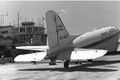 An Israeli aircraft at Atarot Airport in 1968
 -
 The closed entrance to Atarot Airport in 2010, with a police jeep guarding


رموز الإيكاو
The airport is sometimes shown with two different ICAO codes. The LL designator is used by ICAO for airports in Israel and OJ is the code for Jordan.
في الثقافة الشعبية
The airport is depicted in the film World War Z as the main Israeli airport defended from a zombie epidemic. In reality all the Israeli scenes in the film were shot in Malta.
انظر أيضاً
وصلات خارجية
- مطار القدس في موقع lowshot
الهامش
- ^ أ ب Blumenkrantz, Zohar (27 July 2001). "Jerusalem's Atarot Airport handed over to the IDF". Independent Media Review and Analysis Newsletter. Kokhaviv Publications. Archived from the original on 2001-12-22. Retrieved 2014-09-13.
The Airports Authority and the Defense Ministry recently signed an agreement on the army's use of the Atarot airport in Jerusalem. The Israel Defense Forces effectively took over the airport for its own use after it was shut down for civilian air traffic shortly after the start of the Intifada last October [2000]...
- ^ تاريخ إنشاء مطار القدس - ص 55 تاريخ الوصول 10 فبراير 2008 Archived 2016-03-06 at the Wayback Machine
- ^ المجلة اليهودية - عن وضع مطار القدس - بعنوان An Intifada Casualty Named Atarot تاريخ الوصول 10 فبراير 2009 Archived 2016-05-14 at the Wayback Machine
- ^ An Empire in the Holy Land: Historical Geography of the British Administration of Palestine, 1917–1929 Gideon Biger, St. Martin's Press and Magnes Press, New York & Jerusalem, 1994, p. 152
- ^ Oren-Nordheim, Michael; Kark, Ruth (2001). Jerusalem and Its Environs: Quarters, Neighborhoods, Villages, 1800–1948. Wayne State University Press. ISBN 0814329098.[صفحة مطلوبة]
- ^ أ ب Houk, Marian (Autumn 2008). "Atarot and the Fate of the Jerusalem Airport". The Applied Research Institute-Jerusalem. Institute of Jerusalem Studies. Retrieved 2014-09-13.
- ^ محيط - شبكة الأنباء العربية - تتحدث عن فيلم تسجيلي عن المطار تاريخ الوصول 10 فبراير 2009
- Pages using gadget WikiMiniAtlas
- مقالات بالمعرفة بحاجة لذكر رقم الصفحة بالمصدر from September 2014
- Short description is different from Wikidata
- Articles containing عبرية-language text
- Articles containing explicitly cited عربية-language text
- Coordinates on Wikidata
- Airports in the Judea and Samaria Area
- Defunct airports
- Transport in Jerusalem
- مبان ومنشآت في القدس
- 1920 establishments in Mandatory Palestine
- Airports in Israeli-occupied territories
- مطارات فلسطين
- تأسيسات 1920
- تأسيسات 1920 في فلسطين
- 1920 في فلسطين
- القدس