مضيق جبل طارق
| Strait of Gibraltar | |
|---|---|
| مضيق جبل طارق (عربية) Estrecho de Gibraltar (إسپانية) Error {{native name checker}}: list markup expected for multiple names (help) | |
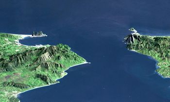
 The Strait of Gibraltar as seen from space. The Iberian Peninsula is on the left and North Africa on the right. | |
| الموقع | Atlantic Ocean – Mediterranean Sea |
| الإحداثيات | 35°58′N 5°29′W / 35.967°N 5.483°W |
| Type | Strait |
| بلدان الحوض | |
| أقل عرض | 14.3 km (8.9 mi) |
| أقصى عمق | 900 متر (2،953 ft) |
يقع هذا المضيق البحري بين المغرب و اسبانيا ومستعمرة جبل طارق البريطانية، ويفصل بين المحيط الاطلسي والبحر الأبيض المتوسط. سمي بذلك لأن القائد طارق بن زياد قد عبره في بداية الفتوحات الاسلامية لاسبانيا عام 711 م. يبلغ عمق المياه فيه حوالي 300 متر، وأقل مسافة بين ضفتيه هي 14 كم. ويبلغ طول المضيق حوالي 51 كم، ويتراوح عرضه بين 13 و37 كم، ويفصل بين أقصى جنوب أسبانيا والشاطئ الشمالي لإفريقيا. ويحده رأس الطرف الأغر في أسبانيا ورأس سبارتل في طنجة من الغرب، بينما تحده من الشرق مستعمرة التاج البريطاني جبل طارق، ورأس ألمينا في شمال أفريقيا. توجد صخور ضخمة على جانبي المضيق في نهايته من ناحية الغرب. هذه الصخور تُسمَّى أَعمدة هرقل. والمياه المتدفقة شرقًا من المحيط الأطلسي تصُب في البحر الأبيض المتوسط عبر المضيق. وللبحر جزر خفيف، والمياه الفائضة منه تحملها غربًا التيارات التحتية التي تجري عبر المضيق نحو المحيط الأَطلسي.
انظر أيضاً
الهامش
وصلاتا خارجية
- Climate Control Requires a Dam at the Strait of Gibraltar—American Geophysical Union, 1997. Accessed 26 February 2006. Gone 12 February 2010. Dam design at http://www.agu.org/sci_soc/eosrjohnsonf3.gif Building the dam and letting the Mediterranean Sea completely evaporate would raise Sea Level 15 meters over 1,000 years. Evaporating the first 100 meters or so would raise Sea Level 1 meter in about 100 years.
- Project for a Europe-Africa permanent link through the Strait of Gibraltar—United Nations Economic and Social Council, 2001. Accessed 26 February 2006.
- Estudios Geográficos del Estrecho de Gibraltar—La Universidad de Tetuán and La Universidad de Sevilla. Accessed 26 February 2006. (in إسپانية)
- "Solitons, Strait of Gibraltar". NASA Earth Observatory. Retrieved 2006-05-24.
- "Internal Waves, Strait of Gibraltar". NASA Earth Observatory. Retrieved 2006-05-24.
- Pages using gadget WikiMiniAtlas
- Short description is different from Wikidata
- Articles containing explicitly cited عربية-language text
- Articles containing إسپانية-language text
- Native name checker template errors
- Coordinates on Wikidata
- Articles with إسپانية-language sources (es)
- مضيق جبل طارق
- Bodies of water of Gibraltar
- Bodies of water of Morocco
- Bodies of water of Spain
- Gibraltar–Spain border
- Important Bird Areas of Gibraltar
- مضائق أفريقيا
- مضائق اوروپا
- تضاريس جبل طارق
- تضاريس المغرب
- تضاريس إسپانيا
- مضائق البحر المتوسط
- مضائق دولية
- الحدود الاسبانية المغربية
- حدود اسبانيا وجبل طارق
- جبل طارق
- جغرافيا المغرب

