غرب ماتا
| غرب ماتا West Mata | |
|---|---|
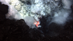
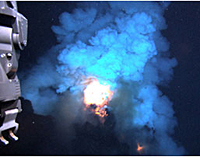
 حِزم من الصهارة المتوهجة من غرب ماتا (مايو 2009) | |
| أعلى نقطة | |
| الارتفاع | -1,100 متر[1] |
| الإحداثيات | 15°06′04″S 173°45′32″W / 15.101°S 173.759°W |
| الجغرافيا | |
 | |
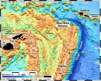
| Location | 200 كم ج.غ. ساموا |
| الجيولوجيا | |
| نوع الجبل | بركان غاطس |
| آخر ثوران | 2008 إلى 2009 |
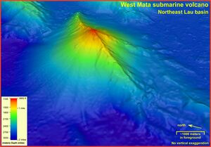
غرب ماتا West Mata هو بركان تحت الماء يقع 200 كيلومتر (120 mi) غرب جنوب جزر ساموا. البركان الذروة يكمن 1،100 مترا تحت سطح الماء. والبركان هو حاليا أعمق بركان مغمور يقذف بالحمم في أعماق المحيط وهو أول بركان يمكن تصويره، قاذفا بالحمم.[2] العلماء بذلوا محاولات لتصوير اندلاع البركان المغمور لمدة 25 عاما.[3]
الجيولوجيا
West Mata is just west of the north in Tonga Ridge where the Tonga Trench makes a sharp turn to the west. It is in the NE Lau Basin about 35 km east of the Lau spreading center and about 70 km northeast of the currently erupting NE Lau spreading center.[4] The Research Vessel Thompson surveyed the area during November 2008 and May 2009. In November 2008, the researchers detected a plume of material over West Mata which indicated likely erupting lava flows and/or pyroclastic materials. The sulfur and iron rich plume contained mineral and/or glass shards. The shard compositions indicated that the erupted material was boninite (an olivine-bronzite andesite with little or no feldspar) which had never been observed from an active volcano.[4]
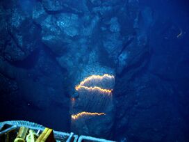
On 6–7 May 2009, the Jason 2 ROV (remotely operated vehicle) was used to observe eruptions from two vents of the linear West Mata peak, Prometheus (at or near the summit) and Hades (slightly to the SW). The Hades vent was erupting both effusively and explosively at the same time on both days (6–7 May). Small bursts were occurring at one end of an erupting fissure ~ 5 m long at a depth of 1,208 m, while pillow lavas were being extruded from the other end. By the next night (7 May) the activity had become more vigorous, sometimes blowing glowing bubbles as much as a meter across from the fissure.[4]
تصويره
في 17 ديسمبر ، 2009 ، نوا صدر إقتراح تصويره بالفيديو والصور الملتقطة من البركان الغاطس وقت إنفجاره وتدافع الحمم. لقطات الفيديو أخذت في مايو 2009 من جانب الاميركي جايسون»Jason remotely operated underwater مركبة الأعماق العاملة بالريموت كونترول (ROV).
العلماء تمولهم مؤسسة العلوم الوطنية (القومية) ونوا قد سجلت بعد اندلاع أعمق بركان اكتشفت -- بركان ماتاالغربية -- يصف الفيديو عالي الوضوح تصف لنا من ثوران البحر بانها "رائعة".
"للمرة الاولى استطعنا أن تدرس ، عن كثب ، الطريقة التى تولد بها يراكين جزر المحيط والبراكين المغمورة " ، قالت باربرا رانسوم ، مدير برنامج في مؤسسة العلوم الوطنية في شعبة علوم المحيطات. "إنها غير عادية والتراكيب بدائية من الحمم الغربية ماتا ثوران لديها الكثير لتقول لنا".
الحمم البركانية ، التي اكتشفت في مايو ، ما يقرب من 4،000 قدم تحت سطح المحيط الهادئ ، في منطقة محدودة من فيجي وتونگا وساموا.
"وجدنا ان هناك نوع من الحمم لم يسبق له مثيل من اندلاع بركان نشط و، للمرة الأولى, ولاحظ الحمم البركانية المتدفقة عبر قاع البحر في أعماق المحيطات "، قال قائد البعثة جوزيف روتبلات ريزنج، وكيمياء المحيطات في جامعة واشنطن"وكان ذلك تحت الماء في الرابع من يوليو ، عرض رائع للالعاب النارية ما يقرب من عمق 4،000 قدم " ، قال كبير العلماء المشاركين في بوب إيمبلى ، وهو جيولوجي بحري في نوا بالمحيط الهادئ مختبر البيئة البحرية في نيوبورت ،
"ولأن ضغط المياه على هذا العمق سوف يقمع العنف من الإنفجارات البركانية, فكان بإمكاننا الحصول على روبوت تحت الماء على مبعدة قدم واحد من موقع الحمم البركانية النشطة. وسواء على اليابسة أو في المياه الضحلة,فلن تأمل أبدا,أن تكون بمثل ذلك القرب , أو تشهد مثل تلك التفاصيل."
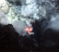
Imagery includes large molten lava bubbles three feet across bursting into cold seawater, glowing red vents exploding lava into the sea, and the first-observed advance of lava flows across the deep-ocean floor. Sounds of the eruption were recorded by a hydrophone and later matched with the video footage.
Expedition scientists released the video and discussed their observations at a December 17, 2009, news conference at the American Geophysical Union (AGU)'s annual fall meeting in San Francisco.
The West Mata Volcano is producing boninite lavas, believed to be among the hottest on Earth in modern times, and a type seen before only on extinct volcanoes more than one million years old. University of Hawaii geochemist Ken Rubin believes that the active boninite eruption provides a unique opportunity to study magma formation at volcanoes, and to learn more about how Earth recycles material where one tectonic plate is subducted under another.
Water from the volcano is very acidic, with some samples collected directly above the eruption, the scientists said, as acidic as battery acid or stomach acid.
Julie Huber, a microbiologist at the Marine Biological Laboratory, found diverse microbes even in such extreme conditions.
Tim Shank, a biologist at the Woods Hole Oceanographic Institution (WHOI), found that shrimp were the only animals thriving in the acidic vent water near the eruption. Shank is analyzing shrimp DNA to determine whether they are the same species as those found at seamounts more than 3,000 miles away. The scientists believe that 80 percent of eruptive activity on Earth takes place in the ocean, and that most volcanoes are in the deep sea.
Further study of active deep-ocean eruptions will provide a better understanding of oceanic cycles of carbon dioxide and sulfur gases, how heat and matter are transferred from the interior of the Earth to its surface, and how life adapts to some of the harshest conditions on Earth.
The science team worked aboard the University of Washington's research vessel Thomas Thompson, and deployed Jason, a remotely-operated vehicle owned by WHOI.
Jason collected samples using its manipulator arms, and obtained imagery using a prototype still and HD imaging system developed and operated by the Advanced Imaging and Visualization Lab at WHOI.
Other expedition participants were affiliated with Oregon State University, Monterey Bay Aquarium Research Institute, Western Washington University, Portland State University, Harvard University, the University of Tulsa, California State University's Moss Landing Marine Laboratory, the University of California Santa Cruz and Lamont Doherty Earth Observatory.
المصادر
المصادر
- ^ "Deepest volcano caught on Pacific Ocean video". British Broadcasting Corporation. 2009-12-18. Retrieved 2009-12-19.
- ^ "Scientists Discover and Image Explosive Deep-Ocean Volcano". NOAA. 2009-12-17. Retrieved 2009-12-19.
Scientists funded by NOAA and the National Science Foundation recorded the deepest erupting volcano yet discovered, describing high-definition video of the undersea eruption as "spectacular." Eruption of the West Mata volcano, discovered in May, occurred nearly 4,000 feet below the surface of the Pacific Ocean, in an area bounded by Fiji, Tonga and Samoa.
- ^ Han, Phil (2009-12-18). "Scientists capture deepest underwater volcanic eruption on film". CNN. Retrieved 2009-12-19.
Scientists have been trying for 25 years to witness an underwater volcanic eruption, but this is the first time it has ever been caught on film.
- ^ أ ب ت Smithsonian Institution, Global Volcanism Program, West Mata
