سومبور
سومبور
Сомбор Sombor | |
|---|---|
مدينة | |
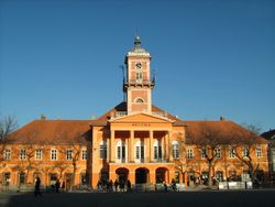 | |
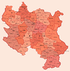
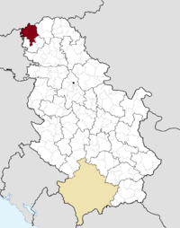 Location of the municipality of Sombor within Serbia | |
| الإحداثيات: 45°47′N 19°07′E / 45.783°N 19.117°E | |
| البلد | |
| المقاطعة | |
| المحافظة | باتشكا الغربية |
| City status | 17 February 1749 |
| المستوطنات | 16 |
| الحكومة | |
| • العمدة | Saša Todorović |
| المساحة | |
| • Municipality | 1٬178 كم² (455 ميل²) |
| التعداد (2011 census)[2] | |
| • Town | 47٬623 |
| • Municipality | 85٬903 |
| منطقة التوقيت | UTC+1 (CET) |
| • الصيف (التوقيت الصيفي) | UTC+2 (CEST) |
| Postal code | 25000 |
| Area code | +381 25 |
| Car plates | SO |
| الموقع الإلكتروني | www |
سومبور (Sombor؛ بالصربية: [Сомбор / Sombor] Error: {{Lang}}: text has italic markup (help)؛ تـُنطق [sɔ̂mbɔr]) هي مدينة في مقاطعة ڤويڤودينا، صربيا. المدينة كان اجمالي تعدادها 47,623 (في 2011)، بينما ضمت منطقتها الادارية (بما فيها القرى المحيطة) 85,903 نسمة. وهي المركز الاداري لـمحافظة باتشكا الغربية.
الاسم وأصله
في الصربية، تُعرف المدينة بإسم سومبور (Сомбор)، وفي المجرية والألمانية هي Zombor، وفي الكرواتية والبونيڤاتس هي Sombor، وفي الروسينية هي زومبور (Зомбор)، وفي التركية صنبر Sonbor.
الاسم المجري الأقدم للمدينة كان Czoborszentmihály. وينبع الإسم من عائلة Czobor، التي كانت تملك هذه المنطقة في القرن 14 (The family name came from the Slavic name Cibor). The Serbian name for the city (Sombor) also came from the family name Czobor, and was first recorded in 1543, although the city was mentioned in historical documents under several more names, such as Samobor, Sambor, Sambir, Sonbor, Sanbur, Zibor, and Zombar.
الاسم الصربي غير الرسمي المستخدم للمدينة هو راڤانگراد (Раванград)، والذي يعني "البلدة المفلطحة".
التاريخ
The first historical record about the city is from 1340. The city was administered by the مملكة المجر until the 16th century, when it became part of the Ottoman Empire. During the establishment of Ottoman authority, local Hungarian population left from this region. During the Ottoman administration, the city was populated mostly by ethnic Serbs.[3] وكانت تسمى "صـُنـْبـُر Sonbor" في العصر العثماني وكانت مقر قضاء في سنجق سگدين الذي كان يتبع في البداية إيالة بودين حتى 1596، ثم صار ضمن إيالة إغري بين 1596 و 1687.
في 1665، زار الرحالة الشهير أوليا چلبي صنبر وكتب: "All the folk (in the city) are not Hungarian, but Wallachian-Christian (Serb[3]). These places are something special; they do not belong to Hungary, but are a part of Bačka and Wallachia. Most of the inhabitants are traders, and all of them wear frontiersmen clothes; they are very polite and brave people." According to Celebi, the city had 200 shops, 14 mosques and about 2,000 houses.
Since 1687, the city was under Habsburg administration, and was included into the Habsburg Military Frontier. In 1717, the first Orthodox elementary school was opened. Five years later a Roman Catholic elementary school was opened as well. In 1745 Sombor was excluded from the Military Frontier and was included into Bacsensis County. In 1749 Sombor gained royal free city status. In 1786, the city became the seat of Bacsensis-Bodrogiensis County. According to 1786 data, the population of the city numbered 11,420 people, mostly Serbs.
According to the 1843 data, Sombor had 21,086 inhabitants, of whom 11,897 were Orthodox Christians, 9,082 Roman Catholics, 56 Jewish, and 51 Protestants. The main language spoken in the city at this time was Serbian, and the second largest language was German. In 1848/1849, Sombor was part of the Serbian Vojvodina, a Serb autonomous region within Austrian Empire, while between 1849 and 1860, it was part of the Voivodship of Serbia and Tamiš Banat, a separate Austrian crown land. Sombor was a seat of the district within voivodship. After the abolishment of this crown land, Sombor again became the seat of the Bacsensis-Bodrogiensis (Bács-Bodrog, Bačka-Bodrog) County.
According to the 1910 census, the population of Sombor was 30,593 people, of whom 11,881 spoke the Serbian language, 10,078 spoke the Hungarian language, 6,289 spoke the Bunjevac language, 2,181 spoke the German language.
In 1918, Sombor became part of the Kingdom of Serbs, Croats and Slovenes (later known as the Kingdom of Yugoslavia). Between 1918 and 1922 it was part of Bačka County, between 1922 and 1929 part of Bačka Oblast, and between 1929 and 1941 part of Danube Banovina.
In 1941, city was occupied by the Axis powers and annexed by Hungary. Many prominent citizen from Serbian community were interned and later executed. In 1944, Yugoslav partisans and Soviet Red Army expelled Axis forces from the city. Since 1944, Sombor was part of the Autonomous Province of Vojvodina of the new Socialist Yugoslavia and (since 1945) socialist Serbia. Today, Sombor is the seat of the West Bačka District.
تاريخ تعداد البلدة
- 1961: 37,760
- 1971: 44,100
- 1981: 48,454
- 1991: 48,993
- 2002: 51,471
- 2011: 47,623
الأماكن المأهولة
المدينة والقرى
Sombor municipality includes the city of Sombor and the following villages:
- Aleksa Šantić
- Bački Breg
- Bački Monoštor
- بزدان
- Gakovo
- Doroslovo
- Kljajićevo
- Kolut
- Rastina
- Riđica
- Svetozar Miletić
- Stanišić
- Stapar
- Telečka
- Čonoplja
المستوطنات الريفية الأخرى
السكان
الجماعات العرقية في منطقة سومبور الادارية
The population of the Sombor administrative area (as of 2011) is composed of:[4]
- Serbs = 54,370 (63.29%)
- Hungarians = 9,874 (11.49%)
- Croats = 7,070 (8.23%)
- Bunjevci = 2,058 (2.4%)
- Roma = 1,015 (1,18%)
- Yugoslavs = 852 (0.99%)
- Others and undeclared = 10,664 (12.41%)
المستوطنات حسب الأغلبية العرقية
Settlements with Serb ethnic majority (in 2002) are: Sombor, Aleksa Šantić, Gakovo, Kljajićevo, Kolut, Rastina, Riđica, Stanišić, Stapar, and Čonoplja. Settlements with Croat/Šokac ethnic majority (in 2002) are: Bački Breg and Bački Monoštor. Settlements with Hungarian ethnic majority (in 2002) are: Bezdan, Doroslovo, and Telečka. Ethnically mixed settlement with relative Hungarian majority is Svetozar Miletić.
الجماعات العرقية في بلدة سومبور
The population of the Sombor town is composed of (2011 census):[4]
- صرب = 32,180 (67.57%)
- كروات = 2,863 (6.01%)
- مجر = 2,851 (5.99%)
- Bunjevci = 1,629 (3.42%)
- يوغسلاڤ = 594 (1.25%)
- مونتنگرين = 475 (1.00%)
- آخرون وغير معلنين = 7,031 (14.77%)
الثقافة
Sombor is famous for its greenery, cultural life and beautiful 18th and 19th century center. The most important cultural institutions are the National Theater, the Regional Museum, the Modern Art Gallery, the Milan Konjović Art Gallery, the Teacher's College, the Serbian Reading House, and the Grammar School. Teacher's College, founded in 1778, is the oldest college in Serbia and the region.
Sombor's rich history includes the oldest institution for higher education in the Serbian language. The town is also home of numerous minority organisations, including the Hungarian Pocket Theater Berta Ferenc, the Croatian Society Vladimir Nazor, the Jewish Municipality and several other smaller organisations including German and Romani clubs.
There are two monasteries in this city:
- دير سومبور الأرثوذكسي, founded in 1928–1933
- Carmelite Catholic monastery, founded in 1904
الإعلام المحلي
الصحافة
- Somborske novine[5]
محطات التلفزيون
محطات الراديو
- Radio Marija (95,7)
- Radio Sombor (97.5)[8]
- Radio Fortuna (106.6)
إعلام الإنترنت
- SOinfo.org[9]
الرياضة
Radnički Sombor is the main football club from the city.
ŽRK Ravangrad Sombor is the main handball club from city.
المدن الشقيقة
المدن الشقيقة:
تعاون إقليمي:
المناخ
Climate in this area has mild differences between highs and lows, and there is adequate rainfall year round. The Köppen Climate Classification subtype for this climate is "Cfb" (Marine West Coast Climate/Oceanic climate).[10]
| بيانات المناخ لـ سومبور (1981–2010, extremes 1961–2010) | |||||||||||||
|---|---|---|---|---|---|---|---|---|---|---|---|---|---|
| الشهر | ينا | فب | مار | أبر | ماي | يون | يول | أغس | سبت | أكت | نوف | ديس | السنة |
| القصوى القياسية °س (°ف) | 19.3 (66.7) |
21.3 (70.3) |
27.6 (81.7) |
29.5 (85.1) |
35.1 (95.2) |
37.1 (98.8) |
40.3 (104.5) |
39.5 (103.1) |
35.7 (96.3) |
29.4 (84.9) |
25.7 (78.3) |
20.7 (69.3) |
40.3 (104.5) |
| متوسط القصوى اليومية °س (°ف) | 3.6 (38.5) |
6.3 (43.3) |
12.0 (53.6) |
17.8 (64.0) |
23.3 (73.9) |
26.1 (79.0) |
28.5 (83.3) |
28.5 (83.3) |
23.7 (74.7) |
18.1 (64.6) |
10.2 (50.4) |
4.5 (40.1) |
16.9 (62.4) |
| المتوسط اليومي °س (°ف) | −0.1 (31.8) |
1.4 (34.5) |
6.2 (43.2) |
11.6 (52.9) |
17.1 (62.8) |
20.2 (68.4) |
21.9 (71.4) |
21.3 (70.3) |
16.5 (61.7) |
11.3 (52.3) |
5.4 (41.7) |
1.1 (34.0) |
11.2 (52.2) |
| متوسط الدنيا اليومية °س (°ف) | −3.4 (25.9) |
−2.6 (27.3) |
1.2 (34.2) |
5.8 (42.4) |
10.8 (51.4) |
13.8 (56.8) |
15.2 (59.4) |
14.7 (58.5) |
10.7 (51.3) |
6.2 (43.2) |
1.7 (35.1) |
−1.8 (28.8) |
6.0 (42.8) |
| الصغرى القياسية °س (°ف) | −27.2 (−17.0) |
−26.3 (−15.3) |
−20.3 (−4.5) |
−5.6 (21.9) |
−1.0 (30.2) |
2.0 (35.6) |
7.3 (45.1) |
4.6 (40.3) |
−2.2 (28.0) |
−6.9 (19.6) |
−18.4 (−1.1) |
−23.7 (−10.7) |
−27.2 (−17.0) |
| متوسط تساقط الأمطار mm (inches) | 37.3 (1.47) |
29.9 (1.18) |
36.4 (1.43) |
45.2 (1.78) |
60.0 (2.36) |
81.5 (3.21) |
66.2 (2.61) |
53.1 (2.09) |
54.4 (2.14) |
47.3 (1.86) |
53.7 (2.11) |
47.4 (1.87) |
612.4 (24.11) |
| Average precipitation days (≥ 0.1 mm) | 11 | 10 | 10 | 12 | 12 | 13 | 10 | 9 | 10 | 9 | 11 | 13 | 128 |
| متوسط الرطوبة النسبية (%) | 84 | 78 | 70 | 66 | 64 | 65 | 64 | 66 | 71 | 75 | 82 | 86 | 72 |
| Mean monthly ساعات سطوع الشمس | 62.2 | 97.5 | 147.6 | 191.8 | 244.1 | 259.5 | 290.3 | 274.3 | 197.1 | 152.5 | 80.4 | 53.0 | 2٬050٫4 |
| Source: Republic Hydrometeorological Service of Serbia[11] | |||||||||||||
انظر أيضاً
- قائمة المدن في صربيا
- List of cities, towns and villages of Vojvodina
- محافظة باتشكا الغربية
- Severtrans
- مطار سومبور
الهامش
- ^ قالب:Serbian municipalities 2006
- ^ قالب:Serbian census 2011
- ^ أ ب http://www.sombor.rs/istorija
- ^ أ ب "Population by ethnicity – Sombor". Statistical Office of the Republic of Serbia (SORS). Retrieved 4 March 2013.
- ^ http://www.somborskenovine.co.rs/
- ^ http://www.rtvspektar.co.rs/
- ^ http://rtvsrece.com/
- ^ http://www.radiosombor.co.rs/
- ^ http://www.soinfo.org/
- ^ Climate Summary for Sombor
- ^ "Monthly and annual means, maximum and minimum values of meteorological elements for the period 1981–2010" (in Serbian). Republic Hydrometeorological Service of Serbia. Retrieved April 9, 2015.
{{cite web}}: CS1 maint: unrecognized language (link)
- Slobodan Ćurčić, Broj stanovnika Vojvodine, Novi Sad, 1996.
