دڤونپورت، نيوزيلندا
Devonport | |
|---|---|
Suburb | |
 | |
| البلد | New Zealand |
| السلطة المحلية | Auckland Council |
| Electoral ward | North Shore Ward |
| Local board | Devonport-Takapuna |
| Established | 1840s |
| التعداد (2018 census) | |
| • الإجمالي | 3٬348 |
| Postcode(s) | 0624 |
| محطة العبارات | رصيف دڤونپورت |
| المستشفى | Navy Hospital |
| (Duders Point) | Vauxhall | Cheltenham |
| Stanley Bay |
|
(North Head) |
| (Waitematā Harbour) | (Waitematā Harbour) | (Waitematā Harbour) |
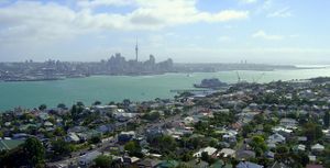
Devonport is a harbourside suburb of Auckland, New Zealand. It is located on the North Shore, at the southern end of a peninsula that runs southeast from near Lake Pupuke in Takapuna, forming the northern side of the Waitematā Harbour. East of Devonport lies North Head, the northern promontory guarding the mouth of the harbour.
The population of Devonport and the adjoining suburb of Cheltenham was 5,340 in the 2013 census, an increase of 3 since 2006.[1] With the additional suburbs of Stanley Bay, Vauxhall and Narrow Neck, the 2006 population was 11,142.[2]
The suburb hosts the Devonport Naval Base of the Royal New Zealand Navy, the main facility for the country's naval vessels, but is best known for its harbourside dining and drinking establishments and its heritage charm. Devonport has been compared to Sausalito, California due to its setting and scenery.[3]
انظر أيضاً
- William C Daldy, a historical steam tug currently berthed in Devonport
الهامش
- ^ The statistical area used by the Census is called Mt Victoria. قالب:NZ Quickstats2013
- ^ "The North Shore". Te Ara: The Encyclopedia of New Zealand. Retrieved 2008-06-16.
- ^ In Auckland, Life Is Alfresco – The New York Times, 5 October 1997
وصلات خارجية
 Devonport (New Zealand) travel guide from Wikivoyage
- Devonport School
- Photographs of Devonport held in Auckland Libraries' heritage collections.