خط العرض 70° شمالاً

خط العرض 70 شمالًا (إنگليزية: 70th parallel north) هي دائرة عرض بزاوية 70 درجة شمال خط الاستواء. تمر دائرة العرض 70° شمالاً عبر أفريقيا، المحيط الهندي، جنوب آسيا، جنوب شرق آسيا، المحيط الهادي، أمريكا الوسطى، امريكا الجنوبية والمحيط الأطلسي.

Line across the Earth
70°
خط العرض 70 شمال
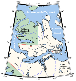
On Victoria Island, Canada, part of the border between Northwest Territories (green) and Nunavut (white) is defined by the 70th parallel north

عند خط العرض هذا، تكون الشمس مرئية لمدة 24 ساعة ، 0 دقيقة أثناء الانقلاب الصيفي، والشفق المدني أثناء الانقلاب الشتوي


. . . . . . . . . . . . . . . . . . . . . . . . . . . . . . . . . . . . . . . . . . . . . . . . . . . . . . . . . . . . . . . . . . . . . . . . . . . . . . . . . . . . . . . . . . . . . . . . . . . . . . . . . . . . . . . . . . . . . . . . . . . . . . . . . . . . . . . . . . . . . . . . . . . . . . . . . . . . . . . . . . . . . . . .

حول العالم

بدءاً من خط الزوال الرئيسي، في الاتجاه الشرقي، يمر خط العرض 70° شمالاً عبر:

الإحداثيات البلد أو الإقليم أو البحر ملاحظات
70°0′N 0°0′E / 70.000°N 0.000°E / 70.000; 0.000 (Prime Meridian) Atlantic Ocean Norwegian Sea
70°0′N 18°40′E / 70.000°N 18.667°E / 70.000; 18.667 (Norway)   نرويج Troms – islands of Rebbenesøya, Ringvassøy, Reinøya, Karlsøya and Kågen; mainland; island of Skorpa; mainland
Finnmark (mainland)
70°0′N 27°22′E / 70.000°N 27.367°E / 70.000; 27.367 (Finland)   فنلندا Passing about 10 km south of the northernmost point of Finland, which is located at 70°05.537′N 27°57.335′E / 70.092283°N 27.955583°E / 70.092283; 27.955583 in the village of Nuorgam
70°0′N 28°2′E / 70.000°N 28.033°E / 70.000; 28.033 (Norway)   نرويج Finnmark
70°0′N 29°30′E / 70.000°N 29.500°E / 70.000; 29.500 (Barents Sea) Barents Sea
70°0′N 58°44′E / 70.000°N 58.733°E / 70.000; 58.733 (Russia)   روسيا Vaygach Island
70°0′N 60°12′E / 70.000°N 60.200°E / 70.000; 60.200 (Barents Sea) Kara Sea
70°0′N 66°56′E / 70.000°N 66.933°E / 70.000; 66.933 (Russia)   روسيا Yamal Peninsula
70°0′N 72°30′E / 70.000°N 72.500°E / 70.000; 72.500 (Gulf of Ob) Gulf of Ob
70°0′N 73°45′E / 70.000°N 73.750°E / 70.000; 73.750 (Russia)   روسيا
70°0′N 159°53′E / 70.000°N 159.883°E / 70.000; 159.883 (East Siberian Sea) East Siberian Sea
70°0′N 168°13′E / 70.000°N 168.217°E / 70.000; 168.217 (Russia)   روسيا Ayon Island
70°0′N 168°31′E / 70.000°N 168.517°E / 70.000; 168.517 (East Siberian Sea) East Siberian Sea
70°0′N 170°35′E / 70.000°N 170.583°E / 70.000; 170.583 (Russia)   روسيا
70°0′N 171°48′E / 70.000°N 171.800°E / 70.000; 171.800 (East Siberian Sea) East Siberian Sea
70°0′N 177°56′E / 70.000°N 177.933°E / 70.000; 177.933 (Chukchi Sea) Chukchi Sea
70°0′N 162°27′W / 70.000°N 162.450°W / 70.000; -162.450 (United States)   الولايات المتحدة Alaska
70°0′N 142°34′W / 70.000°N 142.567°W / 70.000; -142.567 (Beaufort Sea) Beaufort Sea
70°0′N 131°2′W / 70.000°N 131.033°W / 70.000; -131.033 (Canada)   كندا Northwest TerritoriesTuktoyaktuk Peninsula
70°0′N 129°30′W / 70.000°N 129.500°W / 70.000; -129.500 (Beaufort Sea) Beaufort Sea
70°0′N 128°18′W / 70.000°N 128.300°W / 70.000; -128.300 (Canada)   كندا Northwest TerritoriesCape Bathurst Peninsula
70°0′N 126°54′W / 70.000°N 126.900°W / 70.000; -126.900 (Amundsen Gulf) Amundsen Gulf
70°0′N 125°12′W / 70.000°N 125.200°W / 70.000; -125.200 (Canada)   كندا Northwest TerritoriesParry Peninsula
70°0′N 124°30′W / 70.000°N 124.500°W / 70.000; -124.500 (Amundsen Gulf) Amundsen Gulf
70°0′N 117°22′W / 70.000°N 117.367°W / 70.000; -117.367 (Canada)   كندا On Victoria Island:
Northwest Territories
Northwest Territories / Nunavut border
Northwest Territories
Northwest Territories / Nunavut border
Nunavut
70°0′N 100°48′W / 70.000°N 100.800°W / 70.000; -100.800 (Victoria Strait) Victoria Strait
70°0′N 98°50′W / 70.000°N 98.833°W / 70.000; -98.833 (Larsen Sound) Larsen Sound Passing just north of King William Island, Nunavut,   كندا
70°0′N 97°35′W / 70.000°N 97.583°W / 70.000; -97.583 (James Ross Strait) James Ross Strait Passing just north of the Clarence Islands, Nunavut,   كندا
70°0′N 96°17′W / 70.000°N 96.283°W / 70.000; -96.283 (Canada)   كندا Boothia Peninsula, Nunavut
70°0′N 92°1′W / 70.000°N 92.017°W / 70.000; -92.017 (Gulf of Boothia) Gulf of Boothia
70°0′N 86°54′W / 70.000°N 86.900°W / 70.000; -86.900 (Canada)   كندا NunavutCrown Prince Frederik Island
70°0′N 86°27′W / 70.000°N 86.450°W / 70.000; -86.450 (Fury and Hecla Strait) Fury and Hecla Strait
70°0′N 84°20′W / 70.000°N 84.333°W / 70.000; -84.333 (Canada)   كندا NunavutBaffin Island
70°0′N 81°9′W / 70.000°N 81.150°W / 70.000; -81.150 (Murray Maxwell Bay) Murray Maxwell Bay
70°0′N 80°19′W / 70.000°N 80.317°W / 70.000; -80.317 (Canada)   كندا NunavutBaffin Island
70°0′N 78°39′W / 70.000°N 78.650°W / 70.000; -78.650 (Steensby Inlet) Steensby Inlet
70°0′N 77°41′W / 70.000°N 77.683°W / 70.000; -77.683 (Canada)   كندا NunavutBaffin Island
70°0′N 67°20′W / 70.000°N 67.333°W / 70.000; -67.333 (Baffin Bay) Baffin Bay Northern limit of the Davis Strait
70°0′N 53°39′W / 70.000°N 53.650°W / 70.000; -53.650 (Greenland)   گرينلاند Disko Island
70°0′N 52°30′W / 70.000°N 52.500°W / 70.000; -52.500 (Sullorsuaq Strait) Sullorsuaq Strait
70°0′N 51°28′W / 70.000°N 51.467°W / 70.000; -51.467 (Greenland)   گرينلاند Nuussuaq Peninsula
70°0′N 50°37′W / 70.000°N 50.617°W / 70.000; -50.617 (Torsukattak Fjord) Torsukattak Fjord
70°0′N 50°10′W / 70.000°N 50.167°W / 70.000; -50.167 (Greenland)   گرينلاند Sermeq Kujalleq
70°0′N 27°20′W / 70.000°N 27.333°W / 70.000; -27.333 (Gaasefjord) Gaasefjord
70°0′N 25°15′W / 70.000°N 25.250°W / 70.000; -25.250 (Greenland)   گرينلاند Geikie Plateau
70°0′N 22°18′W / 70.000°N 22.300°W / 70.000; -22.300 (Arctic Ocean) Arctic Ocean Greenland Sea
Norwegian Sea


انظر ايضا