خط أودر-نايسه
| التطور الإقليمي لألمانيا في القرن العشرين |
|---|
| ||
|---|---|---|
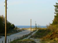
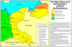
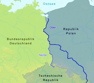
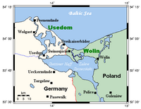
The Oder–Neisse line (ألمانية: Oder-Neiße-Grenze, پولندية: granica na Odrze i Nysie Łużyckiej) is the basis of most of the international border between Germany and Poland. It runs mainly along the Oder and Lusatian Neisse rivers and meets the Baltic Sea in the north, just west of the ports of Szczecin and Świnoujście (German: Stettin and Swinemünde).[1]
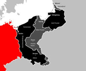
All prewar German territories east of the line and within the 1937 German boundaries—comprising nearly one quarter (23.8 percent) of the Weimar Republic—were ceded under the changes decided at the postwar Potsdam Conference, with the greatest part becoming part of Poland. The remainder, consisting of northern East Prussia with the German city of Königsberg (renamed Kaliningrad), was allocated to the Soviet Union, as the Kaliningrad Oblast of the Russian SFSR (today Russia). A part of the German population in these territories—estimated at approximately 12 million in autumn 1944—had fled the advance of the Red Army.
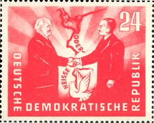
The Oder–Neisse line marked the border between East Germany and Poland from 1950 to 1990. The two Communist governments agreed to the border in 1950, while West Germany, after a period of refusal, adhered to the border, with reservations, in 1970.[2]
After the revolutions of 1989, newly reunified Germany and Poland accepted the line as their border in the 1990 German–Polish Border Treaty.
التاريخ
اعتبارات أثناء الحرب
خلفية
مؤتمر طهران
مؤتمر يالطا
المطالب البولندية والسوفيتية

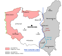
مؤتمر پوتسدام
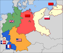
التنازلات
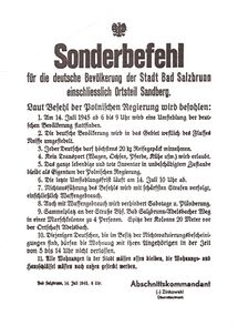
'Recovered territories'
World War II aftermath

German recognition of the border
East Germany
West Germany
Other developments
Division of cities
The border divided several cities into two parts – Görlitz/Zgorzelec, Guben/Gubin, Frankfurt/Słubice and Bad Muskau/Łęknica.[3]
Partially open border 1971–1980
Millions visited the neighbouring country (either Poland or East Germany) during the years 1971–1980.[4][5] The East German economy was threatened by overconsumption of Polish tourists, who came to East Germany to buy cheaper products that the socialist economy could not provide in abundance on either side of the border; and the Poles also became politically dangerous for the GDR government by the time of the 1980 Solidarity strikes.[6]
See also
- Vistula-Oder Offensive, from 12 January until 2 February 1945
- Malta Conference, from 30 January to 3 February 1945
- Yalta Conference, from 4 to 11 February 1945
- Battle of Königsberg, from 6 April until 9 April 1945
- Battle of the Oder-Neisse, from 16 April until 19 April 1945
- Potsdam Conference, from 17 July to 2 August 1945
ملاحظات
مراجع
- ^ Eberhardt, Piotr (2015). "The Oder-Neisse Line as Poland's western border: As postulated and made a reality". Geographia Polonica. 88 (1): 77–105. doi:10.7163/GPol.0007.
- ^ Jessup, John E. (1998). An encyclopedic dictionary of conflict and conflict resolution, 1945-1996. Westport, Conn.: Greenwood Press. p. 543. ISBN 978-0313281129.
- ^ Kimmo Katajala; Maria Lähteenmäki (2012). Imagined, Negotiated, Remembered: Constructing European Borders and Borderlands. LIT Verlag Münster. p. 204. ISBN 978-3-643-90257-3.
- ^ Paul Ganster (1 يناير 1997). Borders and Border Regions in Europe and North America. SCERP and IRSC publications. p. 178. ISBN 978-0-925613-23-3.
- ^ Sven Tägil (1 يناير 1999). Regions in Central Europe: The Legacy of History. C. Hurst & Co. Publishers. p. 244. ISBN 978-1-85065-552-7.
- ^ Paulina Bren; Mary Neuburger (8 أغسطس 2012). Communism Unwrapped: Consumption in Cold War Eastern Europe. Oxford University Press, USA. pp. 377–385. ISBN 978-0-19-982766-4.
ببليوجرافيا
- Ahonen, Pertti (1998). "Domestic constraints on West German Ostpolitik: the role of the expellee organizations in the Adenauer era". Central European History. 31 (1): 31–63. doi:10.1017/S0008938900016034. JSTOR 4546774.
- Allen, Debra J. (2003). The Oder–Neisse line: the United States, Poland, and Germany in the Cold War. Westport: Praeger. ISBN 978-0-313-32359-1.
- Anderson, Sheldon. "The Oder-Neisse Border and Polish-East German relations, 1945-1949." Polish Review 42.2 (1997): 185-199 online.
- Fahlbusch, Michael; Haar, Ingo (2005). German scholars and ethnic cleansing, 1919–1945. Berghahn Books. ISBN 1-57181-435-3.
- Faraldo, José M. (2008). Europe, nationalism, communism: Essays on Poland. Internationaler Verlag der Wissenschaften. ISBN 9783631567623.
- Granville, Johanna (2002). "From the archives of Warsaw and Budapest: a comparison of the events of 1956". East European Politics and Societies. 16 (2): 521–563. doi:10.1177/088832540201600208. S2CID 143214778.
- Granville, Johanna (2003). "Reactions to the events of 1956: new findings from the Budapest and Warsaw archives". Journal of Contemporary History. 38 (2): 261–290. doi:10.1177/0022009403038002133. JSTOR 3180658. S2CID 154087857.
- Hackmann, Jörg (1996). Ostpreussen und Westpreussen in deutscher und polnischer Sicht (in الألمانية). Deutsches Historisches Institut Warschau/Niemiecki Instytut Historyczny w Warszawie. ISBN 3-447-03766-0.
- Ingrao, Charles W.; Szabo, Franz A. J. (2008). The Germans and the East. Purdue University Press. ISBN 978-1-55753-443-9.
- Laufer, Jochen (2009). Pax Sovietica: Stalin, die Westmächte und die deutsche Frage 1941–1945 [Pax Sovietica: Stalin, Western powers and the German question, 1941–1945] (in الألمانية). Böhlau. ISBN 978-3-412-20416-7.
- Lukas, Richard C. (1982). Bitter Legacy: Polish–American Relations in the Wake of World War II. University Press of Kentucky. ISBN 9780813114606.
- Piskorski, Jan M. (2003). Traditionen – Visionen: 44. Deutscher Historikertag in Halle an der Saale 2002 (in الألمانية). Oldenbourg. ISBN 3-486-56769-1.
- Thum, Gregor (2011). Uprooted: How Breslau became Wroclaw during the century of expulsions. Princeton University Press. ISBN 978-0-691-14024-7.
- Wolff-Powęska, Anna (1993). Polacy wobec Niemców. Instytut Zachodni. ISBN 9788385003670.
وصلات خارجية
- An East German pamphlet for propagandists entitled "Why is the Oder-Neiße Line a Peace Border?"
- Treaty between the Federal Republic of Germany and the Republic of Poland on the confirmation of the frontier between them, 14 November 1990(PDF) (Treaty confirming the border between Germany and Poland (Warsaw, 14 November 1990) in Polish and German)
- The Oder Neisse Line Problem (German) (PDF)
- Closing The Ring Winston Churchill; Excerpt on the Teheran conference, from his memoirs.
- Speaking Frankly James F. Byrnes; Excerpt on the Yalta conference, from his memoirs.
- Triumph and Tragedy Winston Churchill; Excerpt on the Yalta conference, from his memoirs.
- Churchill's statement to the House of Commons 27, February 1945, Describing the outcome of Yalta
- The German-Polish Border Region. A Case of Regional Integration? ARENA Working Papers WP 97/19 Jorunn Sem Fure Department of History, University of Bergen
- Pages using gadget WikiMiniAtlas
- Short description is different from Wikidata
- Use dmy dates from September 2016
- Articles containing ألمانية-language text
- Pages using Lang-xx templates
- Articles containing پولندية-language text
- Articles with hatnote templates targeting a nonexistent page
- CS1 الألمانية-language sources (de)
- Coordinates on Wikidata
- Aftermath of World War II in Poland
- Aftermath of World War II in Germany
- Partition (politics)
- 1945 establishments in Europe
