تييرا دل فويگو
- "أرض النار" تحوّل إلى هنا. لمعلومات عن الأمة الخيالية، انظر عالم ناروتو.
 Tierra del Fuego archipelago in the bottom half of the image | |
 Tierra del Fuego archipelago Political map of Tierra del Fuego and mainland South America | |
| الجغرافيا | |
|---|---|
| الموقع | المحيط الهادي، المحيط الأطلسي |
| الإحداثيات | 54°S 70°W / 54°S 70°W |
| الجزر الرئيسية | Tierra del Fuego, Hoste, Navarino, Gordon, Wollastone, Noir, Staten, Hermite, Santa Inés, Clarence, Dawson, Capitán Aracena, Londonderry, Picton, Lennox, Nueva, Diego Ramírez, O'Brien, and Desolación Islands among many others |
| أعلى نقطة | Monte Shipton |
| الإدارة | |
| Region | |
| Provinces | Tierra del Fuego Province and Antártica Chilena |
| Communes | Cabo de Hornos, Antártica, Porvenir, Primavera, Timaukel |
| Province | |
| السكان | |
| التعداد | >135,000 (2010) |
| الجماعات العرقية | Argentines, Chileans, Selknams, Kawésqar, Yaghans |
تييرا دل فويگو (Tierra del Fuego؛ /[invalid input: 'icon']tiːˈɛərə dɛl ˈfweɪɡoʊ/؛ النطق الإسپاني: [ˈtjera ðel ˈfweɣo]؛ وتعني بالإسبانية "أرض النار") هي أرخبيل مقابل الطرف الأقصى جنوباً للبر الرئيسي لقارة أمريكا الجنوبية، عبر مضيق ماجلان. يتكون الأرخبيل من جزيرة إسلا گرانده ده تييرا دل فويگو الرئيسية المقسمة بين تشيلي والأرجنتين ومساحتها 48100 كم²، ومجموعة من الجزر الصغرى منها كيپ هورن. وقد اكتشفها لأول مرة فرديناند ماجلان في رحلته عام 1520، إلا أن الجزر لم يسكنها اوروبيون حتى النصف الثاني من القرن 19 في قمة تربية الخراف والهروع للذهب. واليوم فالنشاط الاقتصادي في الجزء الشمالي من تييرا دل فويگو يتسيدة استخراج النفط، بينما الجزء الجنوبي يتركز في السياحة والصناعة وتحضير الرحلات إلى القارة القطبية الجنوبية. وقد هلك السكان الأصليون من شعبي سلك'نام و ياغان بسبب الأمراض والصراعات غير المتكافئة مع المستوطنين. واليوم فإن شعب سلك'نام قد انقرض فعلياً كشعب متميز، فالقلة المتبقية منه هم مستيزو (مخلطون) ولغتهم انقرضت. بعض الباقون من الياغان استقروا في ڤيلا اوكيكا في جزيرة ناڤارينو، والباقون تناثروا في أرجاء تشيلي والأرجنتين.
تييرا دلْ فويْجو اسم لمجموعة جزر تقع في أقصى الطرف الجنوبي من أمريكا الجنوبية. والاسم تييرا دل فويجو يعني أرض النار. وقد أطلق هذا الاسم فرديناند ماجلان على تلك المنطقة عام 1520م حينما رأى نيرانًا كثيرة تشتعل على طول الساحل، بينما كان يسعى للحصول على ممر إلى المحيط الهادئ، خاصة وأن الهنود الذين كانوا يعيشون هناك، كانوا يوقدون النيران عادة بكميات كبيرة للتدفئة.

تغطي هذه الجزر مساحة 69,600 كم²، ويفصل مضيق ماجلان هذه الجزر عن القارة الأم. أكبر جزيرة بين هذه الجزر تسمى أيضًا تييرا دل فويجو وتغطي مساحة 49,935 كم². وتشغل مدينة يوشووا أحدث مقعد في العالم لحكومة في أمريكا الجنوبية، وهي تقع في هذه الجزيرة. ويعرف أهل الجزر في هذه المنطقة بالفوجيين. ويبلغ عدد سكانها 36,000 نسمة.
تمتلك الأرجنتين الجزء الشرقي من جزيرة تييرا دل فويجو، بينما تمتلك تشيلي الجزء الغربي منها. وفي عام 1948، أقيمت مستوطنة إيطالية في الجزء الأرجنتيني. تمتلك كل من تلكما الدولتين أيضًا كثيرًا من الجزر الصغيرة. بينما تسيطر تشيلي على مضيق ماجلان وتحتفظ بقاعدة بحرية في جزيرة نافارينو. تقع كيب هورن في الطرف الجنوبي من هذه الجزر.
تاريخ

|
| الأقاليم |
| پتاگونيا الشرقية |
| پتاگونيا الغربية |
| تييرا دل فويگو |
| المناطق البيئية |
| الغابات الڤالديڤية |
| الغابات الماجلانية |
| السهوب الپتاگونية |
| الحدائق الوطنية |
| لاگونا سان رفائل |
| لوس گلاسيارس |
| ناهوِل هواپي |
| تورّس دل پاينى |
| كيپ هورن |
| التقسيمات السياسية |
| تشيلي: |
| محافظة پالـِنا • منطقة آيسن • منطقة ماگالانس |
| الأرجنتين: |
| محافظة نيوكن • محافظة ريو نگرو • محافظة تشوبوت • محافظة سانتا كروز • محافظة تييرا دل فويگو |
قبل التاريخ
 مقالة مفصلة: فويغو (شعب)

The earliest human settlement occurred approximately 8,000 BC. The Yaghan were some of the earliest known humans to settle in Tierra del Fuego.[محل شك] Archeological sites with characteristics of their culture have been found at locations such as Navarino Island.[1]
الاستكشاف الأوروبي

The name Tierra del Fuego was given by the Portuguese explorer Ferdinand Magellan while sailing for the Spanish Crown in 1520; he was the first European to visit these lands. He believed he was seeing the many fires (fuego in Spanish) of the Yaghan,[محل شك] which were visible from the sea, and that the "Indians" were waiting in the forests to ambush his armada.[2]
In 1525, Francisco de Hoces was the first to speculate that Tierra del Fuego was one or more islands rather than part of what was then called Terra Australis. Francis Drake in 1578 and a Dutch East India Company expedition in 1616 learned more about the geography. The latter expedition named Cape Horn at Hornos Island.
On his first voyage with إتشإمإس Beagle in 1830, Robert FitzRoy picked up four native Fuegians, including "Jemmy Button" (Orundellico) and Yokcushlu, and brought them to England. The three who survived the voyage were taken to London to meet the king and queen and were, for a time, celebrities. They returned to Tierra del Fuego in the Beagle with Fitzroy and Charles Darwin, who made extensive notes about his visit to the islands.
الاستعمار الأوروبي وانقراض الأمريكان الأصليين (1860–1910)
.jpg&filetimestamp=20231201020441&)
.jpg&filetimestamp=20100921125641&)
During the second half of the nineteenth century, Salesian Catholic missions were established in Río Grande and جزيرة دوسون.
Anglican missionaries, who had established missions on Keppel Island in 1855, established new missions in 1870 at Ushuaia. These missions continued to operate through the nineteenth century. Missionary Thomas Bridges (1842–1898) learned the native language and compiled a 30,000-word Yaghan grammar and dictionary while he worked at Ushuaia.[3] It was published in the 20th century and considered an important ethnological work.[3]
An 1879 Chilean expedition led by Ramón Serrano Montaner reported large amounts of placer gold in the streams and river beds of Tierra del Fuego. This prompted massive immigration to the main island between 1883 and 1909. Numerous Argentines, Chileans, and Croatians settled on the main island, leading to increased conflicts with native Selk'nam. These late nineteenth century gold rushes led to the founding of numerous small settlements by immigrants such as the Argentine settlements of Ushuaia and Río Grande and the Chilean settlements of Porvenir and Puerto Toro.
Julius Popper, a Romanian explorer, was one of the most successful entrepreneurs in the region. Granted rights by the Argentine government to exploit any gold deposits he found in Tierra del Fuego, Popper has been identified as a central figure in the Selk'nam genocide.
Following contact with Europeans, the native Selk'nam and Yaghan populations were greatly reduced by unequal conflict and persecution by settlers, by infectious diseases to which the indigenous people had no immunity, and by mass transfer to the Salesian mission of Dawson Island. Despite the efforts of the missionaries, many natives died. Today, only a few Selk'nam remain. Some of the few remaining Yaghan have settled in Villa Ukika in Navarino Island; others have scattered throughout Chile and Argentina.
Following the signing of the Boundary Treaty of 1881, Tierra del Fuego was divided between Argentina and Chile; previously, it had been claimed in its entirety by both countries.
التاريخ الحديث (1940–الحاضر)
In 1945, a division of Chilean CORFO (Spanish acronym for Production Development Corporation) engaged in oil exploration discovered oil in northern Tierra del Fuego. Extraction began in 1949 and, in 1950, the Chile state-owned ENAP (National Petroleum Company). Until 1960, most oil extracted in Chile came from Tierra del Fuego.[4] During the 1940s Chile and Argentina lodged their Antarctic claims. In the 1950s, the Chilean military founded Puerto Williams. In the 1960s and 1970s, sovereignty claims by Argentina over Picton, Lennox, and Nueva Islands in Tierra del Fuego led the two countries to the brink of war. In 1986, the Argentine congress decided that the Argentine part of Tierra del Fuego should be a new province. This happened in 26 April 1990.[5]
الجغرافيا


The archipelago consists of a main island, Isla Grande de Tierra del Fuego, often simply called Tierra del Fuego or Isla Grande, with an area of 48،100 km2 (18،572 sq mi), and a group of smaller islands. Of the main island the westernmost 29,484.7 km2 (11,384 sq mi, 61.43%) belongs to Chile, and 18,507.3 km2 (7,146 sq mi, 38.57%) belongs to Argentina. The archipelago is divided by an east–west channel, the Beagle Channel, immediately south of the main island. The largest islands south of the Beagle Channel are Hoste and Navarino.
The western part of the main island, and almost all the other islands, belong to Chile. They are part of the Magallanes y Antártica Chilena Region, the capital and chief town of which is Punta Arenas, situated on the mainland across the strait. The largest Chilean towns are Porvenir, capital of the Chilean Province of Tierra del Fuego, located on the main island, and, on Navarino Island, Puerto Williams, which is the capital of the Antártica Chilena Province.
Puerto Toro lies a few kilometers south of Puerto Williams. Arguably, it is the southernmost village in the world. The mostly uninhabited islands north and west of the main island are part of Magallanes Province.
The eastern part of the main island and a few small islands in the Beagle Channel belong to Argentina. They are part of the Tierra del Fuego, Antarctic Territory and South Atlantic Islands Province, whose capital is Ushuaia, the largest city of the archipelago. The other important city in the region is Río Grande on the Atlantic coast.
The Cordillera Darwin in the southwestern part of the main island contains many glaciers that reach the ocean. While Mount Darwin had previously been thought to be the tallest mountain in the archipelago, this distinction now belongs to the unofficially named Monte Shipton at 2،580 متر (8،460 أقدام).[6]
The topography of Tierra del Fuego can be divided into four regions: an outer archipelago region (إسپانية: Región Archipielágica) to the south and west, a mountainous region in the south (إسپانية: Región Cordillerana),[7] a plains region (إسپانية: Región de las Planicies Orientales)[8] plus a sub-Andean zone in-between the last two zones (إسپانية: Región Sub-Andina Oriental).[9]
الجيولوجيا
The geology of the archipelago is characterized by the effects of the Andean orogeny and the repeated Pleistocene glaciations. The geology of the island can be divided into large east–west-oriented units. The southwestern islands of the archipelago, including Cape Horn, are part of the South Patagonian Batholith, while the Cordillera Darwin and the area around the Beagle Channel form the principal mountain range hosting the highest mountains. The Magallanes fold and thrust belt extends north of Almirantazgo Fjord and Fagnano Lake, and north of this lies the Magallanes foreland, an old sedimentary basin that hosts hydrocarbon reserves.[10] Orthogneiss dated at 525 million years is known to underlie some of the oil wells in northern Tierra del Fuego.[11]
The Magallanes–Fagnano Fault, a sinistral strike slip fault crosses the southern part of the main island from west to east. It is an active fault, located inside and parallel to the Fuegian fold and thrust belt, and marks the boundary between a southern belt of Paleozoic meta sediments and a northern Mesozoic belt of sedimentary sequences. Fagnano Lake occupies a glacier-carved depression in a pull-apart basin that has developed along the Magallanes-Fagnano Fault zone.[12]
Podzols and inceptisols occur beneath Nothofagus betuloides forests in Tierra del Fuego.[13]
المناخ

The Tierra del Fuego region has a subpolar oceanic climate (Köppen climate classification Cfc) with short, cool summers and long, wet, moderately mild winters: the precipitation averages 3،000 mm (118 in) a year in the far west, but precipitation decreases rapidly to the eastern side. Temperatures are steady throughout the year: in Ushuaia they hardly surpass 9 °C (48 °F) in summers and average 0 °C (32 °F) in winters. Snowfall can occur in summer. The cold and wet summers help preserve the ancient glaciers. The southernmost islands possess a sub-antarctic climate typical of tundra that makes the growth of trees impossible. Some areas in the interior have a polar climate. Regions in the world with similar climates to southern Tierra del Fuego are: the Aleutian islands, Iceland, the Alaska Peninsula, the Faroe Islands, Macquarie Island, and the Heard and McDonald Islands.
Flora
Only 30% of the islands have forests, which are classified as Magellanic subpolar. The northeastern portion of the region is made up of steppe and cool semi-desert.
Six species of tree are found in Tierra del Fuego: canelo or winter's bark (Drimys winteri), Maytenus magellanica, Pilgerodendron uviferum, the southernmost conifer in the world, and three kinds of southern beech: Nothofagus antarctica, Nothofagus pumilio, and the evergreen Nothofagus betuloides. Several kinds of fruit grow in open spaces in these forests, such as beach strawberry (Fragaria chiloensis var. chiloensis forma chiloensis) and calafate (Berberis buxifolia), which have long been gathered by both Native Americans and residents of European descent.[14] They are the only forests in the world to have developed in a climate with such cold summers. Tree cover extends very close to the southernmost tip of South America. Winds are so strong that trees in wind-exposed areas grow into twisted shapes, inspiring people to call them "flag-trees". Tree vegetation extends to the southern tip of the region, Isla Hornos, although the Wollaston Islands are mostly covered by subantarctic tundra except in wind sheltered areas where the trees can survive.
- Flora in Tierra del Fuego
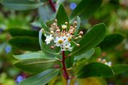
Drimys winteri flowers


Forests from Tierra del Fuego have expanded beyond local importance. These forests have been a source of trees that have been transplanted abroad in places with practically the same climate, but which originally, were devoid of trees, such as the Faroe Islands and nearby archipelagos. Most species were gathered from the coldest places in Tierra del Fuego, mainly sites with tundra borders. This effort resulted in positive changes, as the heavy winds and cool summers in the Faroe Islands did not allow the growth of trees from other regions in the world. The imported trees are used ornamentally, as curtains against wind, and for fighting erosion caused by storms and grazing in the Faroe Islands.[15]
الوحيش

Among the most notable animals in the archipelago are austral parakeets, gulls, guanacos,[16] South American foxes, kingfishers, Andean condors, king penguins, owls, and firecrown hummingbirds.[17] Isla Grande de Tierra del Fuego is also home to the lizard with the world's southernmost distribution, Liolaemus magellanicus.[18]
North American beavers, introduced during the 1940s, have proliferated and caused considerable damage to the island forests. The governments have established a wide-reaching program to trap and kill beavers in Tierra del Fuego.[19]
Like the mainland of Chile and Argentina to the north, this archipelago boasts some of the finest trout fishing in the world. Sea-run brown trout often exceed 9 kg (20 lb), particularly in rivers such as the Rio Grande and the San Pablo, and in the Lago Fagnano. Much of this water is privately owned, with catch and release and fly fishing only.[بحاجة لمصدر]
Waters adjacent to Tierra del Fuego are very rich in cetacean diversity.[20] Sightings of southern right whales in Tierra del Fuego have increased in the 2000s,[21] [22] humpbacks,[23][24] and some others such as blue whales,[25] southern fins, southern seis,[26] and southern minkes.[27][28] Beagle Channel is a prominent area to watch rare, endemic dolphins,[29] and the less-studied pygmy right whales.
Pinnipeds inhabiting the areas include South American sea lions (Otaria flavescens),[30][31] South American fur seals (Arctophoca australis),[32][33] the carnivorous and seal-eating leopard seals (Hydrurga leptonyx),[34] and gigantic southern elephant seals (Mirounga leonine)[35][36] – the largest extant marine mammal that is not a cetacean.
انظر أيضاً
- Alberto de Agostini National Park
- نزاع بيگل
- رحلة البيگل
- متنزه تييرا دل فويگو الوطني
- Yaghan language (متكلم واحد باقي على قيد الحياة)
الهامش
- ^ Hogan, C. Michael (4 April 2008). "Bahia Wulaia Dome Middens". Megalithic Portal. Archived from the original on 10 June 2011. Retrieved 20 June 2011.
- ^ Bergreen, Laurence (2003). Over the Edge of the World: Magellan's Terrifying Circumnavigation of the Globe. HarperCollins. p. 179. ISBN 978-0-06-186588-6.
- ^ أ ب "Cook Tried to Steal Parson's Life Work" (PDF). The New York Times. 21 May 1910. Archived (PDF) from the original on 18 October 2018. Retrieved 30 May 2011.
- ^ Martinić, Mateo (1982) (in es), La Tierra de los Fuegos, Punta Arenas, Chile: Municipalidad de Porvenir, pp. 164–171
- ^ "Historia de Tierra del Fuego" (in الإسبانية). Tierradelfuego.gov.ar. Archived from the original on 17 July 2011. Retrieved 20 June 2011.
- ^ John Shipton (2004). "Monte Shipton or Monte Darwin?" (PDF). Alpine Journal. London: Alpine Club: 132–142. Archived (PDF) from the original on 19 April 2014. Retrieved 28 March 2012.
- ^ Pisano (1977), p. 124
- ^ Pisano (1977), p. 128
- ^ Pisano (1977), p. 125
- ^ Menichetti, M.; Lodolo, E.; Tassone, A. (March 2008). "Structural geology of the Fuegian Andes and Magallanes fold-and-thrust belt – Tierra del Fuego Island". Geologica Acta. 6 (1). Archived from the original on 18 July 2011. Retrieved 20 June 2011.
- ^ Hervé, Francisco; Miller, Hubert; Pimpirev Christo. 2003. Patagonia – Antarctica Connections before Gondwana Break-Up in Antarctica Contributions to Global Earth Sciences. Chapter 5.1
- ^ Lodolo, Emanuele; Menichetti, Marco; Bartole, Roberto; Ben‐Avraham, Zvi; Tassone, Alejandro; Lippai, Horacio (2003). "Magallanes-Fagnano continental transform fault (Tierra del Fuego, southernmost South America)". Tectonics. 22 (6): 1076. Bibcode:2003Tecto..22.1076L. doi:10.1029/2003TC001500.
- ^ Gerding, Victor; Thiers, Oscar (2002), "Characterization of soils of Nothofagus betuloides (Mirb) Blume forests, in Tierra del Fuego, Chile" (in es), Revista Chilena de Historia Natural 75 (4): 819–833, doi:
- ^ Martínez Crovetto, Raúl. 1968. Estudios Etnobotánicos. Nombres de plantas y su utilidad según los indios Onas de Tierra del Fuego, Revista de la Facultad de Agronomía y Veterinaria de la Universidad del Nordeste, Corrientes, Argentina
- ^ Højgaard, A., J. Jóhansen, and S. Ødum (eds) 1989. A Century of Tree Planting in the Faroe Islands, Føroya Frodskaparfelag, Tórshavn.
- ^ "Lama guanicoe". 3 February 2016. doi:10.2305/IUCN.UK.2016-1.RLTS.T11186A18540211.en.
{{cite journal}}: Cite journal requires|journal=(help) - ^ "Sephanoides sephaniodes". 1 October 2016. doi:10.2305/IUCN.UK.2016-3.RLTS.T22687857A93172170.en.
{{cite journal}}: Cite journal requires|journal=(help) - ^ Jaksic, Fabian M. (2022). "Historical account and current ecological knowledge of the southernmost lizard in the world, Liolaemus magellanicus (Squamata: Liolaemidae)". Revista Chilena de Historia Natural. 95 (7). doi:10.1186/s40693-022-00112-y. S2CID 252717680.
- ^ Strieker, Gary (9 July 1999). "Argentina eager to rid island of beavers". Cable News Network. Archived from the original on 3 March 2008. Retrieved 30 June 2007.
- ^ Schiavini, Adrian. "ARGENTINA. PROGRESS REPORT ON CETACEAN RESEARCH, JUNE 2000 TO JUNE 2001". Archived from the original on 10 July 2019.
- ^ "Hoy en Rio Grande, Tierra del Fuego (ballena)". 18 April 2009. Archived from the original on 5 May 2014.
- ^ Goodall, R. Natalie P.; Benegas, G. L.; Dellabianca, N.; Riccialdelli, L.; Pimper, E. L. (17 January 2014). "The Presence of Southern Right Whales off Eastern Tierra del Fuego, 1987–2011" (PDF). Archived from the original (PDF) on 5 May 2014. Retrieved 2014-05-06.
- ^ "Whale Watching in the Southern Cone – Argentina". Archived from the original on 31 May 2014. Retrieved 5 May 2014.
- ^ "Whale Watching in the Southern Cone – Gallery". Archived from the original on 31 May 2014. Retrieved 5 May 2014.
- ^ "Blue Whale (Balaenoptera musculus) on Tierra del Fuego Check List". Archived from the original on 17 September 2016.
- ^ "Minke Whale (Sei Whale?)". 9 December 2011. Archived from the original on 24 June 2016 – via Flickr.
- ^ "Minke Whale (Balaenoptera acutorostrata) on Tierra del Fuego Check List". Archived from the original on 4 January 2018.
- ^ "Record of a dwarf minke whale (Balaenoptera acutorostrata) in northern Brazil" (PDF). Archived (PDF) from the original on 5 May 2014.
- ^ "Scotia Sea: Part 5. The Great Marine Mammals". Archived from the original on 5 May 2014. Retrieved 5 May 2014.
- ^ "Sailing to the Sea Lions and Les Eclaireurs Lighthouse in Catamarans". Archived from the original on 20 January 2013.
- ^ "Southern Sea Lions: Tierra del Fuego, Argentina". 25 September 2011. Archived from the original on 5 May 2014.
- ^ "Mark Horrell: Tierra del Fuego". 28 February 2003. Archived from the original on 4 November 2016 – via Flickr.
- ^ "Ballenas en el Canal de Beagle". Archived from the original on 5 May 2014.
- ^ "Ushuaia Photo: leopard seal". Archived from the original on 20 September 2016.
- ^ "Expedition Uncovers Wildlife Wonders at Tierra del Fuego". 25 February 2011. Archived from the original on 9 July 2011.
- ^ "Cruceros Australis – Fjords of Tierra del Fuego, Patagonia & Cape Horn, Punta Arenas – Ushuaia – Punta Arenas". Archived from the original on 5 May 2014.
المصادر
- Bridges, Lucas. 1948. Uttermost Part of the Earth. Reprint with introduction by Gavin Young, Century Hutchinson, 1987. ISBN 0-7126-1493-1
- Keynes, Richard. 2002. Fossils, Finches and Fuegians: Charles Darwin's Adventures and Discoveries on the Beagle, 1832-1836. Harper Collins Publishers, London. Reprint: 2003.
- Bollen, Patrick. 2000. "Tierra del Fuego" B/W Photobook. Lannoo Publishers, Tielt, Belgium. ISBN 90-209-4040-6
وصلات خارجية
 Media related to Tierra del Fuego at Wikimedia Commons
 "Tierra del Fuego". Encyclopædia Britannica (11th ed.). 1911.
- Pages using gadget WikiMiniAtlas
- CS1: Julian–Gregorian uncertainty
- CS1 الإسبانية-language sources (es)
- Short description is different from Wikidata
- Coordinates on Wikidata
- Articles containing إسپانية-language text
- Ill-formatted IPAc-en transclusions
- مقالات ذات عبارات محل شك
- Articles with hatnote templates targeting a nonexistent page
- Pages using Lang-xx templates
- Articles with unsourced statements from September 2011
- تييرا دل فويگو
- جزر الأرجنتين
- جزر تشيلى
- مناطق أمريكا الجنوبية
- Geography of Magellan and Chilean Antarctica Region