تريتوار دى بلفور (إقليم فرنسي)
إقليم بلفور
Territoire de Belfort | |
|---|---|
 View to the west from the Citadelle de Belfort | |
 Flag الشعار  Coat of arms | |
 موقع تريتوار دى بلفور في فرنسا | |
| الإحداثيات: 47°45′N 7°00′E / 47.750°N 7.000°E | |
| البلد | فرنسا |
| المنطقة | بورگون-فرانش-كومتيه |
| Prefecture | بلفور |
| Subprefectures | (none) |
| الحكومة | |
| • President of the Departmental Council | Florian Bouquet[1] (LR) |
| المساحة | |
| • الإجمالي | 609٫4 كم² (235٫3 ميل²) |
| التعداد (يناير 2019) | |
| • الإجمالي | 141٬318 |
| • الترتيب | 99th |
| • الكثافة | 230/km2 (600/sq mi) |
| منطقة التوقيت | UTC+1 (CET) |
| • الصيف (التوقيت الصيفي) | UTC+2 (CEST) |
| Department number | 90 |
| Arrondissements | 1 |
| Cantons | 9 |
| Communes | 101 |
| ^1 French Land Register data, which exclude estuaries, and lakes, ponds, and glaciers larger than 1 km2 | |

إقليم بلفور ( Territoire de Belfort ؛ النطق الفرنسي: [tɛʁitwaʁ də bɛlfɔʁ] (![]() استمع)) هو إقليم في منطقة بورگون-فرانش-كومتيه، بشرق فرنسا. وبلغ عدد سكانها 141,318 نسمة في 2019.[2] رقمه التسلسلي 90 .
استمع)) هو إقليم في منطقة بورگون-فرانش-كومتيه، بشرق فرنسا. وبلغ عدد سكانها 141,318 نسمة في 2019.[2] رقمه التسلسلي 90 .
التاريخ
The administrative district Territoire de Belfort was created under the terms of the 1871 Treaty of Frankfurt. The German Empire annexed almost all of Alsace, but the French were able to negotiate retention of the Territoire de Belfort which thereby was separated from the rest of Alsace (where it had been part of the department of Haut-Rhin). There were three principal reasons for this exceptional treatment:
- The population in and around Belfort was French-speaking.
- Belfort had demonstrated heroic resistance, under Colonel Pierre Denfert-Rochereau, to the German invasion. Belfort's left-wing Catholic Deputy Émile Keller now conducted a similarly forceful political campaign in the National Assembly. He argued that ceding heroic Belfort to Germany after the war would be unthinkable.
- Since Belfort is situated in a relatively flat passage between the Vosges and Jura mountain ranges (known as the Belfort Gap), the Germans agreed to leave the city in France, because the Prussian military officers indicated that this strategy would give Germany a more defensible border.[3]
After retaining its unique status as a territoire for just over half a century, Belfort was officially recognized as France's 90th department in 1922. France had recovered Alsace three years earlier, but the decision was taken not to reintegrate Belfort into its former department. There was talk of giving it a new departmental name, with suggestions that included "Savoureuse" (after the main river of the new department) or "Mont-Terrible" (the name of a former Napoleonic department embracing parts of Switzerland), but there was no consensus for a name change and the department continues to be known as the Territoire de Belfort.
When the regions of France were created, Belfort was not included in the region of Alsace, but the adjacent region of Franche-Comté, since January 2016 Bourgogne-Franche-Comté.
الجغرافيا
Geographers might contend that Belfort lies on the ridge that divides two regions of France, but before 1870 it was politically part of Alsace. However, in terms of the political regions established in 1982, the Territoire de Belfort has found itself in the Franche-Comté rather than Alsace.
The department has an area of only 609 km2 (235 sq. miles), being the fifth smallest of France (after Paris and its suburbs Hauts-de-Seine, Seine-Saint-Denis, and Val-de-Marne). It is sightly smaller than Malta or the State of Rhode Island.
البلدات الرئيسية
أكبر البلدات تعداداً هي بلفور، وهي عاصمة الإقليم. وفي 2019، there are 4 communes with more than 5,000 inhabitants:[2]
| البلدة | التعداد (2019) |
|---|---|
| بلفور | 46,443 |
| Delle | 5,667 |
| ڤالدوا | 5,269 |
| بوكور | 5,010 |
الاقتصاد
The median net income per household for the department in 2017 was €21,310. The averaged figure for the Territoire de Belfort masked relatively large disparities such as, in particular, that between Belfort itself at €17,920 and Bermont at €26,600.[4]
Population and demography
In 2019 the department recorded a population of 141,318. Of these, slightly more than 46,000 live in the commune of Belfort itself.
|
| |||||||||||||||||||||||||||||||||||||||||||||||||||||||||||||||
| Sources:[5][6] | ||||||||||||||||||||||||||||||||||||||||||||||||||||||||||||||||
Four principal phases can be identified in the population trends during the two centuries between 1801 and 2000.
- the period from 1800 to 1872 was marked by steady economic development and a relatively high birth rate. However, the cholera epidemic which in 1851 arose from increasing urbanisation, along with a more general economic slow-down, reduced the rate of increase in the third quarter of the century. Between 1803 and 1872 the recorded population increased from 37,558 to 56,781.
- after the loss to Germany of most of Alsace in 1871, the Belfort population was boosted by the arrival of large numbers of refugees from "Germanisation": the years between 1871 and 1914 saw the development of large factories, with the mechanical and textile sectors being prominent growth areas. The population increase and the economic development were at their most intense in the Belfort conglomeration itself. By 1911 the territoire's population figure stood at 101,392.
- in the years between 1914 and 1945 the economic narrative was dominated by two world wars and the period of stagnation that came between them. Population declined, having slipped to 86,648 in 1946.
- after 1945 the region became a focus for industrial growth: population levels followed the same rising trend, to stand at 131,999 in 1982. Nevertheless, as in many parts of France, from about 1980 it was clear that the economic crisis of the 1970s was having a lasting effect in slowing the pace of expansion.
الإدارة
Its departmental code is 90, and its prefecture (capital) is Belfort. There is a single arrondissement (Belfort), which is subdivided into 9 cantons and thence into 101 communes.
السياسة
The president of the Departmental Council is Florian Bouquet, first elected in 2015.
التمثيل الحالي في الجمعية الوطنية
| Constituency | Member[7] | Party | |
|---|---|---|---|
| Territoire de Belfort's 1st constituency | Ian Boucard | The Republicans | |
| Territoire de Belfort's 2nd constituency | Michel Zumkeller | Union of Democrats and Independents | |
التمثيل الحالي في مجلس الشيوخ
| Constituency | Member[8] | Party | |
|---|---|---|---|
| Territoire de Belfort's Senate constituency | Cédric Perrin | The Republicans | |
السياحة
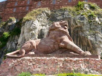
أسد بلفور يخلد مقاومة بلفور أثناء الحرب الپروسية الفرنسية.
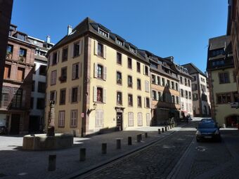
شوارع في بلفور

شلال في نهر ساڤوروز
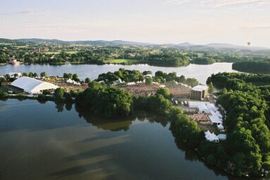
مهرجان موسيقى Eurockéennes


انظر أيضاً
- Communes of the Territoire de Belfort department
- Cantons of the Territoire de Belfort department
- Arrondissement of Belfort
المراجع
- ^ "Répertoire national des élus: les conseillers départementaux". data.gouv.fr, Plateforme ouverte des données publiques françaises (in الفرنسية). 4 May 2022.
- ^ أ ب Populations légales 2019: 90 Territoire de Belfort, INSEE
- ^ "Bismarks Mittheilung über den Friedendschluss". Passauer Zeitung. Vol. 24, no. 124. 16 May 1871. p. 1.
- ^ "Comparateur de territoire: Commune de Belfort (90010), Territoire de Belfort (90), Commune de Bermont (90011)". INSEE. Retrieved 9 September 2020.
- ^ "Historique du Territoire de Belfort". Le SPLAF.
- ^ "Évolution et structure de la population en 2016". INSEE.
- ^ Assemblée Nationale. "Assemblée nationale ~ Les députés, le vote de la loi, le Parlement français". Assemblee-nationale.fr. Retrieved 2022-03-19.
- ^ "Liste par département - Sénat". www.senat.fr. Retrieved 2020-07-22.
وصلات خارجية
 Media related to تريتوار دى بلفور (إقليم فرنسي) at Wikimedia Commons
- (in فرنسية) Prefecture website
- (in فرنسية) Departmental council website
- (in إنگليزية) Tourist Office website
قالب:Constituencies of Territoire de Belfort
| International | |
|---|---|
| National | |
- Pages using gadget WikiMiniAtlas
- صفحات بها مخططات
- CS1 الفرنسية-language sources (fr)
- CS1: Julian–Gregorian uncertainty
- Short description is different from Wikidata
- Coordinates on Wikidata
- Articles containing فرنسية-language text
- Articles with hatnote templates targeting a nonexistent page
- Articles with فرنسية-language sources (fr)
- Articles with إنگليزية-language sources (en)
- أقاليم فرنسا
- Territoire de Belfort
- 1871 establishments in France
- Departments of Bourgogne-Franche-Comté
- States and territories established in 1871
- States and territories established in 1922
- 1922 establishments in France
- إقليم بلفور