بحر سالتون
| بحر سالتون Salton sea | |
|---|---|
 | |
| الموقع | صحراء كلورادو مقاطعتي إمپريال وريڤرسايد، كاليفورنيا، الولايات المتحدة |
| الإحداثيات | 33°18′47″N 115°50′04″W / 33.31306°N 115.83444°W |
| Type | بحيرة صدعية تجميعية |
| الموارد الرئيسية | نهر ألامو النهر الجديد نهر وايتواتر |
| التصريفات الرئيسية | لا يوجد |
| منطقة المستجمعات | 8،360 ميل مربع (21،700 km2) |
| بلدان الحوض | الولايات المتحدة-المكسيك |
| مساحة السطح | 343 sq mi (889 km2) |
| أقصى عمق | 43 ft (13 m) |
| حجم المياه | 6،000،000 acre⋅ft (7.4 km3) |
| ارتفاع السطح | −236 ft (−71.9 m) (تحت سطح البحر) |
| التجمعات السكنية | بومباي بيتش، ديزرت بيتش، ديزرت شورز، سالتون سيتي، سالتون سيتي بيتش، نورث شور |
| المراجع | U.S. Geological Survey Geographic Names Information System: بحر سالتون |
| خطأ: الوظيفة "auto" غير موجودة. | |
| خطأ: الوظيفة "autocaption" غير موجودة. | |
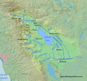
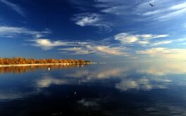
بحر سالتون إنگليزية: Salton Sea وهو مسطح مائي ضحل غير ساحلي عالي الملوحة في مقاطعات ريڤرسايد و إمپريال في الطرف الجنوبي لولاية كاليفورنيا الأمريكية. يقع البحر على فالق سان أندرياس داخل غور سالتون الذي يمتد حتى خليج كاليفورنيا في المكسيك. على مدى ملايين السنين، تدفق نهر كولورادو إلى وادي إمپريال مما أدى لترسب الطمي (التربة)، مما أدى إلى خلق الأراضي الزراعية الخصبة، وبناء التضاريس، وتحريك مسارها الرئيسي ودلتا النهر. لآلاف السنين، كان النهر يتدفق بالتناوب إلى الوادي، أو ينحرف حوله، مكوناً إما بحيرة مالحة تسمى بحيرة كاويا، أو حوض صحراوي جاف، على التوالي. عندما يتدفق نهر كولورادو إلى الوادي، يعتمد مستوى البحيرة على تدفقات النهر والتوازن بين التدفق الداخلي وفقدان التبخر. عندما ينحرف النهر حول الوادي، تجف البحيرة تماماً، كما حدث في حوالي عام 1580. وقد تم العثور على مئات من المواقع الأثرية في هذه المنطقة، مما يشير إلى احتمال وجود قرى أمريكية أصلية طويلة الأمد وأكواخ مؤقتة.
تشكلت البحيرة الحالية من تدفق المياه من نهر كولورادو في عام 1905. وبدءاً من عام 1900، تم حفر قناة ري من نهر كولورادو إلى قناة نهر ألامو القديمة لتوفير المياه إلى وادي إمپريال الزراعي. وقد حافظت البوابات والقنوات على تراكم الطمي، لذلك تم إجراء سلسلة من التخفيضات في ضفة نهر كولورادو لزيادة تدفق المياه. كما اخترقت المياه من فيضانات الينابيع من خلال بوابة رأس القناة لتحويل جزء من تدفق النهر إلى حوض سالتون لمدة عامين قبل اكتمال الإصلاحات. وقد خلقت المياه الموجودة في قاع البحيرة الجافة سابقاً البحيرة الحديثة، والتي تبلغ حوالي 15 في 35 ميل (24 في 56 km).
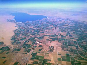
كانت البحيرة ستجف، لكن المزارعين استخدموا كميات سخية من مياه نهر كولورادو وتركوا الفائض يتدفق إلى البحيرة. في الخمسينيات والستينيات من القرن الماضي، أصبحت المنطقة وجهة سياحية، ونمت المجتمعات بالفنادق وبيوت العطلات. كانت مراقبة الطيور شائعة أيضاً لأن الأراضي الرطبة كانت محطة استراحة رئيسية على مسار الطيور المهاجرة في المحيط الهادئ.
في سبعينيات القرن الماضي، أصدر العلماء تحذيرات من أن البحيرة ستستمر في الانكماش وتصبح غير قابلة لاستقبال الأحياء البرية. في الثمانينيات، أدى التلوث الناتج عن تصريف مياه المزارع إلى انتشار الأمراض وانتشارها. كما حدثت حالات نفوق جماعية للطيور، خاصة بعد فقدان العديد من أنواع الأسماك التي يعتمدون عليها. وقد ارتفعت الملوحة بدرجة كبيرة بحيث انتشرت ظاهرة موت الأسماك، مما أدى في كثير من الأحيان إلى تدمير شواطئ البحر بجيفها. مما انخفضت السياحة بشكل كبير.
بعد عام 1999، بدأت البحيرة في الانكماش حيث استخدمت الزراعة المحلية المياه بكفاءة أكبر مما أدى إلى تدفق كميات أقل من الجريان السطحي إلى البحيرة. عندما أصبح قاع البحيرة مكشوفاً، أرسلت الرياح سحباً من الغبار السام إلى المجمعات المجاورة. وصلت كميات صغيرة من الغبار إلى منطقة لوس أنجلوس ويمكن للناس هناك في بعض الأحيان أن يشموا رائحة قادمة من البحيرة. الولاية مسؤولة بشكل أساسي عن حل المشاكل، وتعهد المشرعون في كاليفورنيا بتمويل مشاريع إدارة جودة الهواء بالتزامن مع توقيع اتفاقية 2003 لإرسال المزيد من المياه إلى المدن الساحلية. كما وجدت الهيئات المحلية والولائية والفدرالية جميعها نجاحاً ضئيلًا في التعامل مع الغبار والأحياء البرية النافقة وغيرها من المشكلات التي صدرت بشأنها تحذيرات قبل عقود. في بداية عام 2018، أعلنت الوكالات المحلية حالة الطوارئ، وقامت جنباً إلى جنب مع الدولة، بتمويل وتطوير برنامج إدارة بحر سالتون.
في عام 2020، لخصت مجلة پالم سپرنگز لايف الوضع البيئي بأن "بحر سالتون يستمد شهرته باعتباره أكبر كارثة بيئية في تاريخ كاليفورنيا".[1]
بعد بداية بطيئة وبعض المشاريع الصغيرة، بدأ البناء في مشروع بقيمة 206.5 مليون دولار في أوائل عام 2021 على دلتا نهر نيو، مما أدى إلى إنشاء برك وأراضي رطبة على الشاطئ الجنوبي من البحر.
التاريخ
قبل العصر الحديث
The Gulf of California would extend as far north as the city of Indio, were it not for the delta created by the Colorado River.[2] Over three million years, through all of the Pleistocene, the river's delta expanded until it cut off the northern part of the gulf. Since then, the Colorado River has alternated between emptying into the basin, creating a freshwater lake, and emptying into the gulf, leaving the lake to dry and turn to desert. Wave-cut shorelines at various elevations record a repeated cycle of filling and drying over hundreds of thousands of years.[3] The most recent freshwater lake was Lake Cahuilla,[3] also known as the Blake Sea[4] after American professor and geologist William Phipps Blake.[5] It covered over 2،000 ميل مربع (5،200 km2), six times the area of the Salton Sea.[3]
Archaeological sites and radiocarbon dates indicate that the lake was filled three or four times over the last 1300 years. When full, the lake would attract Native Americans to its shores. Hundreds of sites have been found, some possibly long-term villages and other temporary camps. The occupants ate at least four species of fish (two of which were razorback sucker and bonytail chub), birds (particularly the coot), black-tailed jackrabbit, black-tailed cottontail rabbit, and sometimes deer and bighorn sheep. Among the plants they used were bulrush, cattail, mesquite, and saltbush. The Cahuilla people have an oral memory of the last lake, which existed in the 17th century and dried up soon after 1700.[6]
Throughout the Spanish period of California's history, the area was referred to as the "Colorado Desert" after the Colorado River. In a railroad survey completed in 1855, it was called "the Valley of the Ancient Lake". On several old maps from the Library of Congress, it has been found labeled "Cahuilla Valley" (after the local Native American tribe) and "Cabazon Valley" (after a local Native American chief – Chief Cabazon). "Salt Creek" first appeared on a map in 1867 and "Salton Station" is on a railroad map from 1900, although this place had existed as a rail stop since the late 1870s.[7] Until the advent of the modern sea, the Salton Sink was the site of a major salt-mining operation.[8]
التشكل الحديث
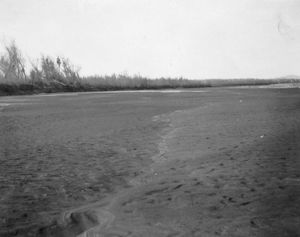
In 1900, under governor James Budd, the California Development Company began construction of irrigation canals to divert water from the Colorado River into the Salton Sink, a dry lake bed. After construction of these irrigation canals, the Salton Sink became fertile for a time, allowing farmers to plant crops.[8]
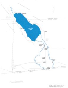
Within two years, the Alamo Canal became filled with silt from the Colorado River. Engineers tried to alleviate the blockages to no avail. In 1905, heavy rainfall and snowmelt caused the Colorado River to swell, overrunning the third intake cut into the bank of the river and sending the flood into the Alamo Canal. The resulting flood poured down the canal, and down two former dry arroyos, the New River in the west, and the Alamo River in the east, each about 60 mi (97 km) long.[9] Over about two years, these two newly created rivers carried the entire volume of the Colorado River into the Salton Sink.[10][11]
The Southern Pacific Railroad tried to stop the flooding by dumping earth into the canal's headgates area, but the effort was not fast enough, and the river eroded deeper and deeper into the dry desert sand of the Imperial Valley. A large waterfall formed as a result and began cutting rapidly upstream along the path of the Alamo Canal that now was occupied by the Colorado. This waterfall was initially 15 أقدام (4.6 m) high, but grew to 80 أقدام (20 m) high before the flow through the breach was stopped. Originally, the waterfall was feared to recede upstream to the true main path of the Colorado, becoming up to 100 إلى 300 أقدام (30 إلى 90 m) high, when it would be practically impossible to stop the flow.
As the basin filled, the town of Salton, a Southern Pacific Railroad siding, the New Liverpool Salt Company facility and miniature railroad, and Torres-Martinez Native American land were submerged. The tribe's reservation now straddles the northern end of the lake.[12] The sudden influx of water and the lack of any drainage from the basin resulted in the formation of the Salton Sea.[13][14][15]
الزراعة والسياحة وانتشار الحياة البرية
In the 1920s, agriculture had boomed in the valley as the Imperial Irrigation District delivered large quantities of Colorado River water to irrigate the crops. The lake would have dried up naturally, but with flood irrigation being commonly used, plenty of water ran off the farms into the lake and kept it full.[16] The district holds senior rights to water from the Colorado River according to Doctrine of Prior Appropriation, which is based on whoever first put the water to beneficial use could continue to claim it.[17] In 1930, a wildlife refuge was established on some wetlands along the edge of the lake that had attracted many birds. The fish flourished in the lake and provided a source of food for massive populations of migratory birds. Birdwatchers flocked to this new refuge in the middle of a desert.[16]
The continuing intermittent flooding of the Imperial Valley from the Colorado River ended with the construction of Hoover Dam. The Imperial Dam, built in 1938, serves as a desilting dam for water entering the irrigation canals.[18]
In the 1950s and into the 1960s, the communities expanded as the area's reputation as a resort destination and sport fishery grew.[19] Hotels and yacht clubs were built on the shore along with homes and schools.[20] Resorts in communities like Bombay Beach hosted entertainers such as Frank Sinatra, The Beach Boys and Bing Crosby.[21] Yacht clubs held parties at night and golf courses provided recreation.[20] Many people came for boating activities such as water skiing and fishing as stocked fish proliferated.[22] Lakeshore communities grew as vacation homes were built.[16] More than 1.5 million visitors visited annually at the peak.[23]
تدهور كارثي
In the 1970s, scientists issued warnings about the changes coming to this lake with no outlet. Studies that started in the 1960s found a complex problem for which any remediation would be expensive.[21] The Imperial Valley has about 500،000 acre (200،000 ha) of farmland for which flood irrigation is typical.[17] Water from the Colorado River is diverted near Yuma, Arizona, into the 82-ميل (132 km) All-American Canal. The canal runs west along the Mexican border and then north into 1،700 ميل (2،700 km) of irrigation channels that crisscross the farms.[24]
انكشاف قاع البحيرة يؤثر على جودة الهواء
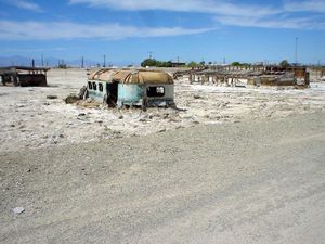
The lake continued to dry up, exposing more lake bed known as playa, and sending nearby communities clouds of toxic dust.[25] A haze incorporating pesticide plumes, exhaust fumes, factory emissions, and the vaporized dust from the lake regularly hangs over the communities in the valley.[26] With a dense blend of ozone and particulate matter, Imperial County became known for some of the worst air quality in the country.[22] Eastern Coachella communities have disproportionately higher rates of asthma and respiratory complications because of high concentrations of contaminants in the air.[27] Over 20% of the children in the region have asthma (with the national rate being less than 10%).[28] Scientists are studying how much of this is due to the Salton Sea dust and what is actually in the windblown particles.[29] Ten schools in the Imperial Valley use green, yellow, and red flags signaling air quality for the many children who have asthma. Green means they join their friends on the playground, whereas red means they stay inside all day. Parents can also receive emailed alerts from the Imperial County Air Pollution Control District.[30] Local activists ask if this is an issue of environmental justice, since the area most impacted is 85% Latinos.[31][32] Some 650,000 people, many who are farmworkers, live where there are significant exposure to the dust.[33] The public health impacts of continuing not to meet federal air quality standards include the treatment of child and adult asthma, Cardiac Disease, lung cancer, and increased mortality rates.[33] Lower concentrations of the wind-borne dust travels all the way into Southern California and Arizona.[34] Residents in the Los Angeles Basin, some 150 ميل (240 km) away, complained about the odor that drifted their way in 2012, after the biomass on the sea bottom was churned by a storm.[35][36][22]
During the first 15 years after the sale of the Imperial water to San Diego County, the Imperial Irrigation District has been required to put water into the Salton Sea to compensate for the loss of agricultural runoff needed to replenish the sea. As the 2017 deadline for ending the additional mitigation water approached, the district, along with Imperial County, petitioned the California State Water Resources Control Board in 2014 with a demand for state action to fulfill its obligation after years of delays and unfulfilled plans.[37] Pacific Institute, an environmental think tank, was warning that the lack of replenishment water was leading to a "period of very rapid deterioration."[33][38] The rapidly shrinking sea was a "looming environmental and public health crisis".[39] With the increased shrinkage, dust storms would increase and the rotten-egg smell would reach the coastal cities more frequently.[38][23]
About 36،000 acre (15،000 ha), or about 10%, of Imperial Valley's arable farmland has been temporarily fallowed to meet the reductions in the water transfer agreement.[40] The farms in the Imperial Valley produce alfalfa, wheat, and vegetables such as carrots and Brussels sprouts.[41] اعتبارا من 2015[تحديث], the most widely planted crop was alfalfa, followed by bermuda grass and sudan grass. A third of the hay produced here was exported to China, the United Arab Emirates, Saudi Arabia, and Japan. Most of exported hay feeds dairy cows, while Japan uses it for Kobe beef.[17]
On January 1, 2018, 40% less water began flowing into the sea as the 15-year mitigation period ended per the 2003 water transfer agreement.[42] A court decision also forced the Imperial Irrigation District to end a program that had allowed it to equally distribute and cap the amount of water its members receive.[42] Although it had been shrinking for years, this began to lower the water level significantly. As the shore recedes, at least 75 ميل مربع (190 km2) of playa will be exposed by 2045, with additional dust becoming wind blown as the exposed playa dries out.[22] A vertical drop of one foot in the water level can expose thousands of feet of horizontal playa.[23] The state is mainly responsible, as California lawmakers pledged to fund air-quality management projects to mitigate impacts from the 2003 water transfer agreement.[33] Over the years, local, state and federal bodies have found minimal success dealing with the dust from the exposed playa.[34] To reduce wind-borne dust, the district has a program known as vegetation enhancement and surface roughening, which includes plowing furrows on newly exposed playa within property owned by the district.[42]
Fugitive dust, consisting of very small particles suspended in air, is being studied to distinguish between playa dust and desert emissions that are primarily made up of mineral dust from soil. The Imperial County Air Quality Management District, the South Coast Air Quality Management District, and the University of California at Riverside School of Medicine along with the environmental justice group Comite Civico Del Valle are using mobile and stationary air quality monitoring units in the effort to protect the health of the nearby residents.[43]
برنامج إدارة بحر سالتون
The Salton Sea Task Force was formed by the state in 2015 by Governor Jerry Brown's administration.[44] The Natural Resources Agency released the Salton Sea Management Program (SSMP) in March 2017.[37] The SSMP proposes constructing 29،800 acre (12،100 ha) of habitat restoration and dust suppression projects on lakebed areas that have been, or will be, exposed at the Salton Sea by the year 2028.[45] This will improve conditions for residents and wildlife.[46] The initial 10-year plan will cover less than half of the dry lakebed that researchers say will be exposed during that time.[47] The state initially budgeted $80.5 million to begin designing the wetlands without a commitment that the program will ever be fully funded.[46] The projected cost to design and construct the improvements is $383 million.[41] The focus was no longer on restoring the lake but presenting a feasible plan with a budget that legislators would gradually fund over the ten-year period. The 10-year plan won't fix everything so state and local officials continue to seek ways to deal with the problems.[48] Salton Sea Management Program Monitoring and Adaptive Management Implementation Plan is being developed that will prioritize and phase-in implementation of the 2013 USGS Salton Sea Ecosystem Monitoring and Assessment Plan.[49]
The first state-funded project was the Torres-Martinez Wetland Project. The Torres Martinez Desert Cahuilla Indians partnered with the state to restore shallow wetlands along the northern edge of the sea that was destroyed by a massive storm in 2012.[50] This prototype project was completed in April 2018.[51]
In November 2019, an emergency was declared because of the "heavily polluted New River, which empties into the Salton Sea".[21][52] The Imperial County Board of Supervisors were hoping that this would accelerate the restoration projects by enabling the state to obtain federal funding.[21] Nearly all the state's funding comes from bond measures for the Salton Sea projects. Since 2000, California voters have approved five bond measures اعتبارا من 2020[تحديث].[53]
In February 2020, the California Natural Resources Agency finished the "Bruchard Road Dust Suppression Project" which, although only 112 acre (45 ha), was the first dust suppression project to be completed under the Salton Sea Management Program: Phase 1: 10 Year Plan (August 2018).[53] Construction began on the ambitious 4،110-acre (1،660 ha) Species Conservation Habitat Project in January 2021 on the small delta of the New River.[32] The $206.5 million project is building ponds and wetlands on both sides of the mouth of this highly polluted river on the southern bank of the sea.[54] The federal government said in November 2022, it will spend $250 million over four years for the project.[55]
مراجعة استيراد الماء
Many concepts have been proposed on how to deal with the problems.[56] The idea of importing seawater from the Pacific Ocean or the Sea of Cortez in Mexico has been around for a long time. The area's plentiful geothermal power could be used to desalinate the water.[12] Around 2004, Aqua Genesis Ltd proposed such a project that would sell the nonsaline water. Their proposal involved the construction of over 20 ميل (32 km) of pipes and tunneling that would have provided 1،000،000 فدان-أقدام (1.2 km3) of water to Southern California coastal cities each year.[57] Berkshire Hathaway Energy has a subsidiary that already operates 10 geothermal plants in the area, and اعتبارا من 2020[تحديث] was developing a seawater desalination proposal.[12]
In 2018, the California Natural Resources Agency requested proposals to increase waterflow to the sea to reduce dust and dust-borne toxins. The 11 proposals ranged in cost from $300 million to several billion dollars.[58]
A June 9, 2020, research report stated that the cost of "transferring water from agricultural users to the Salton Sea" would be lower and achievable using existing infrastructure.[59] The aqueduct proposal, and others, hung on the outcome of a feasibility study.[60] The state-appointed panel of experts rejected the idea after a yearlong review.[61]
الجغرافيا
الجيولوجيا
وضع البراكين والتكتونيات
The Salton Sea and surrounding basin sits over the San Andreas Fault, San Jacinto Fault, Imperial Fault Zone, and a "stepover fault" shear zone system. Geologists have determined that previous flooding episodes from the Colorado River have been linked to earthquakes along the San Andreas Fault. Sonar and other instruments were used to map the Salton Sea's underwater faults during the study. During the period when the basin was filled by Lake Cahuilla, a much larger inland sea, earthquakes higher than magnitude 7 occurred roughly every 180 years, the last one occurring within decades of 1700. Computer models suggest the normal faults in the area are most vulnerable to deviatoric stress loading by filling in of water. Currently, a risk still exists for an earthquake of magnitude 7 to 8. Simulations also showed, in the Los Angeles area, shaking and thus damage would be more severe for a San Andreas earthquake that propagated along the fault from the south, rather than from the north. Such an earthquake also raises the risk for soil liquefaction in the Imperial Valley region.[62][63]
The effective drainage divide that separates the Salton Sea from the Gulf of California is about 30 أقدام (9 m) in elevation and is located near Delta, northeastern Baja California State, Mexico, south-southeast of Mexicali.[64] Past sea level rise may partially be responsible for the salinity of the lake, while potential future changes in sea levels could occur. However, other factors such as hydrothermal vents, diffusion of salt from minerals and sediment, including concentrated brine, and evaporites are another contributor to salinity, as is the recent lowering of lake levels raising the salinity, though sedimentary records show the lake surface elevation reached levels 33 إلى 39 أقدام (10 إلى 12 m) above world sea level in the 1500s.[65]
النشاط البركاني
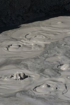
Evidence of geothermal activity is visible. The Salton Buttes are volcanoes in the geothermal field of the same name. Mudpots and mud volcanoes are found on the eastern side of the Salton Sea,[66] including the mobile Niland Geyser.[67] The area is used for geothermal electricity generation, with plants located along the southeastern shore of the Salton Sea in Imperial County.[68][69][70]
إنتاج الليثيوم
يؤدي النشاط الحراري الأرضي تحت بحر سالتون إلى إطلاق الليثيوم الذي يمكن استخراجه. نظراً لزيادة الطلب على الليثيوم، وهو أمر بالغ الأهمية لإنتاج بطاريات السيارات الكهربائية، تجذب منطقة بحر سالتون الانتباه، ومن المتوقع أن يعزز استخراج الليثيوم الاقتصاد المحلي.[71]حيث يحتوي المحلول الملحي على الليثيوم والكالسيوم والصوديوم ومعادن أخرى معقدة للغاية لفصله.[72]وتقدر لجنة كاليفورنيا للطاقة أن البحر قد ينتج 600 ألف طن متري من كربونات الليثيوم سنوياً.[73]
في يوليو 2021، أعلنت جنرال موتورز أنها دخلت في شراكة مع شركة كونترولد ثرمال للموارد لتطوير منشأة مشتركة لاستخراج الليثيوم وتوليد الطاقة في "حقل هلز كتشن" (مطبخ الجحيم) للطاقة الحرارية الأرضية في بحر سالتون، وذلك باستخدام عملية الحلقة المغلقة. سيتم استخراج المحلول الملحي من الأرض، مع استخدام البخار الحراري الأرضي لتشغيل التوربينات لتوليد الكهرباء، والتفاعل مع المحلول الملحي لفصل هيدروكسيد الليثيوم وكربونات الليثيوم المستخدمة في إنتاج البطاريات.[74][75]
تمتلك فرع شركة بركشير هاثاواي للطاقة تدير 10 محطات للطاقة الحرارية الأرضية في المنطقة.[12] ويخطط قسم BHE للطاقة المتجددة في بركشير لافتتاح مصنع تجريبي لكربونات الليثيوم في ربيع عام 2023.[72]
البيئة
التلوث السمكي
تلوث الطيور
الملوحة المتزايدة

التجمعات
درجة حرارة المياه
في الثقافة العامة
المنظر

انظر أيضاً
الهوامش
- ^ Black, Kent (March 4, 2020). "Bombay Beach Riding Resurgence Wave With Literary Week Set". Palm Springs Life (in الإنجليزية الأمريكية). Retrieved January 22, 2021.
- ^ Alles, DL (August 6, 2007). "Geology of the Salton Trough" (PDF). Biology Department. Western Washington University. Retrieved June 6, 2010.
- ^ أ ب ت Singer, Eugene. "Ancient Lake Cahuilla". Excerpted from Geology of the Imperial Valley, a monograph by Eugene Singer. Archived from the original on June 1, 2009. Retrieved July 10, 2009.
- ^ Aschmann, Homer (January 1, 1959). "The Evolution of a Wild Landscape and Its Persistence in Southern California". Annals of the Association of American Geographers. 49 (3): 34–56. JSTOR 2561246.
- ^ Patten, Michael A.; McCaskie, Guy; Unitt, Philip (2003). Birds of the Salton Sea: Status, Biogeography, and Ecology. University of California Press. p. 2. ISBN 9780520235939.
- ^ Schaefer, Jerry. "Prehistoric Native American Responses to Ancient Lake Cahuilla". California Department of Fish and Wildlife. Retrieved January 23, 2021.
- ^ Carpelan, Lars H. (c. 1954). "History of the Salton Sea". Fish Bulletin. California Department of Fish and Wildlife (113). Retrieved January 25, 2021.
- ^ أ ب Laflin, P. (1995). "Chapters 1–4". The Salton Sea: California's overlooked treasure. Indio, California: Coachella Valley Historical Society. Retrieved 21 فبراير 2026.
{{cite book}}:|work=ignored (help) - ^ Detailed maps, and a film of the breach (and subsequent redamming) are in Metzler, Chris and Springer, Jeff (directors) (2004). Plagues & Pleasures on the Salton Sea (Documentary). Tilapia Film.
- ^ Laflin, P. (1995). "Chapters 5–6". The Salton Sea: California's overlooked treasure. Indio, California: Coachella Valley Historical Society. Retrieved 21 فبراير 2026.
{{cite book}}:|work=ignored (help) - ^ Cory, Harry Thomas; Blake, William Phipps (1915). The Imperial Valley and the Salton Sink. San Francisco: John J. Newbegin. Retrieved January 25, 2021.
- ^ أ ب ت ث خطأ استشهاد: وسم
<ref>غير صحيح؛ لا نص تم توفيره للمراجع المسماةUSA2 2017 pt-4 - ^ Kennan, G (1917). The Salton Sea: An Account of Harriman's Fight With The Colorado River. New York: The Macmillan Company. Retrieved July 11, 2009.
- ^ Larkin, EL (1907). "A Thousand Men Against A River: The Engineering Victory Over The Colorado River And The Salton Sea". The World's Work: A History of Our Time. XIII: 8606–10. Retrieved July 10, 2009.
- ^ Martin, Frank G. (May 1906). "The New Inland Sea In California". Appleton's Magazine. pp. 679–684. Retrieved November 26, 2022.
- ^ أ ب ت خطأ استشهاد: وسم
<ref>غير صحيح؛ لا نص تم توفيره للمراجع المسماةNG 2018/12 - ^ أ ب ت Goodyear, Dana (May 4, 2015). "The dying sea: what will California sacrifice to survive the drought?". Letter from the Imperial Valley. The New Yorker. Vol. 91, no. 11. pp. 22–27. Retrieved June 29, 2015.
- ^ Jaspers, Bret (March 6, 2018). "The Colorado River's First Dam Transformed The Desert Southwest". KPBS Public Media (in الإنجليزية). Retrieved February 27, 2021.
- ^ Streitfeld, David (July 1, 2007). "Salton City: A land of dreams and dead fish". Los Angeles Times (in الإنجليزية الأمريكية). Retrieved February 5, 2021.
- ^ أ ب Morton, Ella (February 4, 2014). "Salton Sea: From Relaxing Resort to Skeleton-Filled Wasteland". Slate (in الإنجليزية الأمريكية). ISSN 1091-2339. Retrieved January 30, 2021.
- ^ أ ب ت ث خطأ استشهاد: وسم
<ref>غير صحيح؛ لا نص تم توفيره للمراجع المسماةthefern.org - ^ أ ب ت ث Zelenko, Michael (June 6, 2018). "Dust Rising". The Verge. Retrieved October 15, 2020.
- ^ أ ب ت Iovenko, Chris (November 9, 2015). "California's Largest Lake Is Now a Public-Health Threat". The Atlantic (in الإنجليزية). Retrieved March 8, 2021.
- ^ Spagat, Elliot (June 3, 2015). "Salton Sea threatened by urban water transfer". Southern California Public Radio. Associated Press. Retrieved March 10, 2021.
- ^ Wilson, Janet (January 31, 2021). "Imperial Valley water champion Kevin Kelley, who fought to save the Salton Sea, dies at 61". The Desert Sun (in الإنجليزية الأمريكية). Retrieved February 5, 2021.
- ^ Singh, Maanvi (July 24, 2021). "'The air is toxic': how an idyllic California lake became a nightmare". The Guardian (in الإنجليزية). Retrieved November 3, 2021.
{{cite news}}: CS1 maint: url-status (link) - ^ Rodriguez, Olivia; Sinclair, Ryan (April 25, 2020). "Valley Voice: Salton Sea communities needed relief long before coronavirus". The Desert Sun (in الإنجليزية الأمريكية). Retrieved October 15, 2020.
- ^ Biddle, T.; Chakraborty, R.; Li, Q.; Maltz, M.; Gerrard, J.; Lo, D. (2022-04-22). "The drying Salton Sea and asthma: A perspective on a "natural" disaster". California Agriculture (in English). 76 (1): 27–36. doi:10.3733/ca.2022a0003. ISSN 0008-0845. S2CID 248348750.
{{cite journal}}: CS1 maint: unrecognized language (link) - ^ Pittalwala, Iqbal (May 24, 2019). "Dust to Dust: How the Salton Sea's toxic dust is poisoning the community". UC Riverside Magazine (in الإنجليزية). Retrieved February 22, 2021 – via Medium.
- ^ خطأ استشهاد: وسم
<ref>غير صحيح؛ لا نص تم توفيره للمراجع المسماةUSA2 2017 pt-2 - ^ "House Appropriations Subcommittee Issues Testimony From Riverside County Flood Control and Water Conservation District General Manager Uhley". InsuranceNewsNet (in الإنجليزية الأمريكية). March 11, 2021. Retrieved March 12, 2021.
Exposed seabed's and frequent dust storms have caused significant air quality issues adding to the worsening health problems in one of California's poorest regions, where Latinos make up the majority of the population and many are farmworkers and essential workers.
- ^ أ ب Anderson, Erik (March 1, 2021). "State Water Project Takes Aim At Restoring Salton Sea, Alleviating Health Risks". KPBS Public Media (in الإنجليزية). Retrieved March 4, 2021.
- ^ أ ب ت ث خطأ استشهاد: وسم
<ref>غير صحيح؛ لا نص تم توفيره للمراجع المسماةPI 2014 - ^ أ ب Olalde, Mark (December 21, 2020). "Will California finally fulfill its promise to fix the Salton Sea?". High Country News (in الإنجليزية الأمريكية). The Desert Sun, USA Today Network. Retrieved February 5, 2021.
- ^ Von Quednow, Cindy (September 10, 2012). "Foul odor reported in Simi Valley may have originated in Salton Sea". Ventura County Star (in الإنجليزية). Retrieved February 23, 2021.
- ^ خطأ استشهاد: وسم
<ref>غير صحيح؛ لا نص تم توفيره للمراجع المسماةWM 2012-09-14 - ^ أ ب James, Ian (November 7, 2017). "California commits to timetable for Salton Sea projects". Ventura County Star (in الإنجليزية الأمريكية). The Desert Sun, USA Today Network. Retrieved February 19, 2021.
- ^ أ ب Perry, Tony (November 21, 2014) "'Looming environmental crisis' at Salton Sea prompts plea for help" Los Angeles Times
- ^ Perry, Tony (September 3, 2014) "'Salton Sea inaction could cause 'catastrophic change,' report says" Los Angeles Times
- ^ خطأ استشهاد: وسم
<ref>غير صحيح؛ لا نص تم توفيره للمراجع المسماةNG 2014-02-18 - ^ أ ب James, Ian (March 16, 2017). "California has a new $383 million plan for the shrinking Salton Sea". The Desert Sun. Archived from the original on June 17, 2017. Retrieved February 19, 2021.
- ^ أ ب ت خطأ استشهاد: وسم
<ref>غير صحيح؛ لا نص تم توفيره للمراجع المسماةKPBS 2018/3/21 - ^ Dooley, Emily C. (April 9, 2021). "Salton Sea Dust, Air Quality to Get Closer Look in California". Bloomberg Law News (in الإنجليزية). Retrieved April 13, 2021.
- ^ Congressional Research Service 2020
- ^ "SPL-2019-00951-KJD Salton Sea Management Program 10-Year Plan Projects" (Press release) (in الإنجليزية الأمريكية). US Army Corps of Engineers, Los Angeles District. March 17, 2021. Retrieved 2022-06-22.
- ^ أ ب Metz, Sam (January 8, 2020). "Newsom wants an extra $220 million for Salton Sea plan in upcoming California state budget". The Desert Sun (in الإنجليزية الأمريكية). Retrieved February 18, 2021.
- ^ خطأ استشهاد: وسم
<ref>غير صحيح؛ لا نص تم توفيره للمراجع المسماةUSA2 2017 pt-1 - ^ Roth, Sammy (June 9, 2017). "Salton Sea: A history of broken promises". The Desert Sun. Retrieved February 18, 2021.
- ^ Testimony of Wade Crowfoot, California Secretary for Natural Resources House Natural Resources Committee Subcommittee on Water, Oceans and Wildlife. California Natural Resources Agency. September 24, 2020. Archived from the original. You must specify the date the archive was made using the
|archivedate=parameter. https://naturalresources.house.gov/imo/media/doc/Crowfoot%20Written%20Testimony%20House%20Natural%20Resources%20Subcommittee%20Testimony%2092420.pdf. Retrieved on February 22, 2021. - ^ خطأ استشهاد: وسم
<ref>غير صحيح؛ لا نص تم توفيره للمراجع المسماةDS 2015/12/06 - ^ Rosentrater, Phil (April 20, 2018). "First state-funded project completed at the Salton Sea". Salton Sea Authority (Press release) (in الإنجليزية الأمريكية). Association of California Water Agencies. Retrieved February 13, 2021.
- ^ خطأ استشهاد: وسم
<ref>غير صحيح؛ لا نص تم توفيره للمراجع المسماةKPBS 2019/mar/14 - ^ أ ب Olalde, Mark (February 26, 2020). "California Natural Resources Agency lays out aggressive Salton Sea mitigation goals". The Desert Sun.
- ^ Olalde, Mark (January 13, 2021). "Salton Sea habitat project breaks ground near New River delta". The Desert Sun (in الإنجليزية الأمريكية). Retrieved February 7, 2021.
- ^ Ronayne, Kathleen (2022-11-29). "Drying California lake to get $250M in US drought funding". AP News (in الإنجليزية). Retrieved 2022-11-29.
- ^ خطأ استشهاد: وسم
<ref>غير صحيح؛ لا نص تم توفيره للمراجع المسماةUS Bureau of Reclamation 1999 - ^ Deegan, Joe (February 26, 2004). "Inventor Tackles Salton Sea Disaster". San Diego Reader (in الإنجليزية). Retrieved February 24, 2021.
- ^ Metz, Sam (April 16, 2018). "10 questions about the 11 proposals to save the Salton Sea". The Desert Sun (in الإنجليزية الأمريكية). Retrieved January 22, 2021.
- ^ Levers, L.; Story, S.; Schwabe, K. (June 9, 2020). "Boons or boondoggles: An assessment of the Salton Sea water importation options". California Agriculture (in English). 74 (2): 73–79. doi:10.3733/ca.2020a0009. ISSN 0008-0845.
{{cite journal}}: CS1 maint: unrecognized language (link) - ^ Parker, Chuck; Nunez, Feliz (July 7, 2020). "Valley Voice: Importing water to save the Salton Sea can work. Let's prove and do it now". The Desert Sun (in الإنجليزية الأمريكية). Retrieved January 22, 2021.
- ^ James, Ian (October 5, 2022). "As Salton Sea faces ecological collapse, a plan to save it with ocean water is rejected". Los Angeles Times (in الإنجليزية الأمريكية).
- ^ Brothers, Daniel; Kilb, Debi; Luttrell, Karen; Driscoll, Neal; Kent, Graham (July 2011). "Loading of the San Andreas fault by flood-induced rupture of faults beneath the Salton Sea". Nature Geoscience. 4 (7): 486–492. Bibcode:2011NatGe...4..486B. doi:10.1038/ngeo1184.
- ^ Ross, JE (June 26, 2011). "Flooding of Ancient Salton Sea Linked to San Andreas Earthquakes". Scripps Institution of Oceanography. University of California at San Diego. Retrieved 21 فبراير 2026.
- ^ Tingle, A. "Flood Maps". Firetree.net. Flood. Retrieved July 31, 2011.
- ^ Wardlaw, GD; Valentine DL (January 2005). "Evidence for salt diffusion from sediments contributing to increasing salinity in the Salton Sea, California" (PDF). Hydrobiologia. 533 (1–3): 77–85. doi:10.1007/s10750-004-2395-8. S2CID 20454442. Archived from the original (PDF) on April 16, 2007. Retrieved July 31, 2011.
- ^ Lynch, DK; Hudnut, KW (2008). "The Wister Mud Pot Lineament: Southeastward Extension or Abandoned Strand of the San Andreas Fault?" (PDF). Bulletin of the Seismological Society of America. 98 (4): 1720–29. Bibcode:2008BuSSA..98.1720L. doi:10.1785/0120070252.
- ^ Reyes-Velarde, Alejandra; Lin II, Rong-Gong (November 1, 2018). "A San Andreas fault mystery: The 'slow-moving disaster' in an area where the Big One is feared". Los Angeles Times.
- ^ Cart, Julie (February 25, 2021). "Will California's desert be transformed into Lithium Valley?". CalMatters (in الإنجليزية الأمريكية). Retrieved February 26, 2021.
- ^ Roth, Sammy (October 14, 2019). "Lithium will fuel the clean energy boom. This company may have a breakthrough". Los Angeles Times (in الإنجليزية الأمريكية). Retrieved October 17, 2019.
- ^ Baker, David R. (November 19, 2020). "California Wants Its Imperial Valley to Be 'Lithium Valley'". Bloomberg Business (in الإنجليزية). Retrieved November 19, 2020.
- ^ Fernández, Caleb J. (August 31, 2021). "Lithium fuels hope for Salton Sea" (in الإنجليزية الأمريكية). KYMA. Associated Press. Retrieved September 4, 2021.
- ^ أ ب Scheyder, Ernest (2022-10-05). "U.S. steps away from flagship lithium project with Buffett's Berkshire". Reuters (in الإنجليزية). Retrieved 2022-10-06.
- ^ Alistair MacDonald and Jim Carlton. (February 8, 2022). "Where Is There More Lithium to Power Cars and Phones? Beneath a California Lake.". Wall Street Journal Retrieved February 9, 2022.
- ^ Abuelsamid, Sam (July 2, 2021). "GM Invests In Controlled Thermal Resources For U.S. Lithium Production". Forbes (in الإنجليزية). Retrieved September 4, 2021.
- ^ Dunn, Jason. "GM changes strategy in the scramble for secure battery and chip supply". Automotive Logistics (in الإنجليزية). Retrieved September 4, 2021.
- ^ Salton Trough July 29, 2013
المصادر
- Metzler, Chris and Springer, Jeff – Plagues & Pleasures on the Salton Sea, Tilapia Film, (2006) – history of the Salton Sea, and interviews with residents and naturalists.
- Stevens, Joseph E. Hoover Dam. University of Oklahoma Press, 1988. details on the Salton Sea disaster
- Stringfellow, Kim Greetings from the Salton Sea: Folly and Intervention in the Southern California Landscape, 1905-2005. Columbia College Chicago Press, 2005. ISBN 978-1-935195-32-0
قراءات إضافية
- Setmire, James G., et al. (1993). Detailed study of water quality, bottom sediment, and biota associated with irrigation drainage in the Salton Sea area, California, 1988–90 [Water-Resources Investigations Report 93-4014]. Sacramento, Calif.: U.S. Department of the Interior, U.S. Geological Survey.
- Setmire, James G., Wolfe, John C., and Stroud, Richard K. (1990). Reconnaissance investigation of water quality, bottom sediment, and biota associated with irrigation drainage in the Salton Sea area, California, 1986–87 [Water-Resources Investigations Report 89-4102]. Sacramento, Calif.: U.S. Department of the Interior, U.S. Geological Survey.
- Sperry RL (Winter 1975). "When the Imperial Valley Fought for its Life". Journal of San Diego History. 21 (1).
- Greenfield S (Winter 2006). "A Lake by Mistake". Invention & Technology. 21 (3).[dead link]
وصلات خارجية
- Official Salton Sea Authority website
- U.S. Bureau of Reclamation: Salton Sea Restoration Project Office
- Abandoned USA.com: Photos of the Salton Sea
- Salton Basin overview
- Salton Sea data and other resources
- Mavensmanor.com: "From the Colorado River to the Salton Sea: The story of Imperial Valley's Water" — slideshow.
- "The Salton Sea" — Photo Essay by Scott London
- National Geographic photos of the Salton Sea
- Calexico New River Committee, New River Tributary
- GoogleBooks.com: The Salton Sea: An account of Harriman's fight with the Colorado River
- Youtube.com: "The Accidental Sea"
- Howser, Huell (October 3, 1999). "Salton Sea – Visiting (705)". California's Gold. Chapman University Huell Howser Archives.
- Saltonseadocumentary.com: Plagues & Pleasures on the Salton Sea — documentary film.
- Pages using gadget WikiMiniAtlas
- CS1 الإنجليزية الأمريكية-language sources (en-us)
- CS1 errors: periodical ignored
- CS1 maint: url-status
- Short description is different from Wikidata
- Coordinates on Wikidata
- Articles containing إنگليزية-language text
- Pages using Lang-xx templates
- مقالات فيها عبارات متقادمة منذ 2015
- جميع المقالات التي فيها عبارات متقادمة
- مقالات فيها عبارات متقادمة منذ 2020
- Pages using div col with unknown parameters
- Articles with dead external links from September 2012
- بحر سالتون
- بحيرات تجميعية في كاليفورنيا
- بحيرات مقاطعة ريڤرسايد، كاليفورنيا
- بحيرات مالحة
- بحيرات منكمشة
- وادي كواچلا
- كوارث في كاليفورنيا
- فشل هندسي
- بيئة كاليفورنيا
- كوارث بيئية في كاليفورنيا
- جغرافيا صحراء كولورادو
- تضاريس مقاطعة إمپريال، كاليفورنيا
- مناطق طيور هامة في كاليفورنيا
- التاريخ الطبيعي لمقاطعة إمپريال، كاليفورنيا
- معالم سياحية في مقاطعة إمپريال
- بحيرات كاليفورنيا


