الواس
Elvas | |
|---|---|
.jpg&filetimestamp=20210308172800&) .jpg&filetimestamp=20210308172759&) .jpg&filetimestamp=20210308172759&) .jpg&filetimestamp=20210308172758&) .jpg&filetimestamp=20210308172757&) .jpg&filetimestamp=20210308172757&) .jpg&filetimestamp=20210308172756&) | |
 Flag  Coat of arms | |
 | |
| Coordinates: 38°52′N 7°09′W / 38.867°N 7.150°W | |
| البلد | |
| المنطقة | ألنتيجو |
| Intermunic. comm. | Alto Alentejo |
| District | Portalegre |
| Parishes | 7 |
| Government | |
| • الرئيس | Dr. Nuno Miguel Fernandes Mocinha (PS) |
| Area | |
• Total | 631٫29 كم² (243٫74 ميل²) |
| Population (2011) | |
• Total | 23٬078 |
| • Density | 37/km2 (95/sq mi) |
| Time zone | UTC±00:00 (WET) |
| • Summer (DST) | UTC+01:00 (WEST) |
| العطلات العامة | January 14 |
| Website | http://www.cm-elvas.pt |
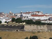
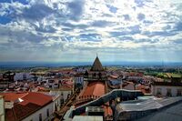
الواس أو إلڤاش (برتغالية: Elvas؛ النطق في البرتغالية: [ˈɛlvɐʃ] (![]() استمع)) هي بلدية برتغالية، تقع في مقاطعة پورتالگري في ألنتيجو البرتغال، على بعد 200 كم شرق لشبونة، وعلى بعد 8 كم شرق حصن بطليوس الاسباني.[1] يقدر عدد سكانها بـ 23,078 نسمة ومساحتها 631.29 كم².[2]
استمع)) هي بلدية برتغالية، تقع في مقاطعة پورتالگري في ألنتيجو البرتغال، على بعد 200 كم شرق لشبونة، وعلى بعد 8 كم شرق حصن بطليوس الاسباني.[1] يقدر عدد سكانها بـ 23,078 نسمة ومساحتها 631.29 كم².[2]
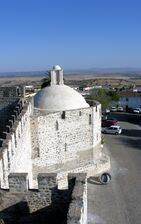
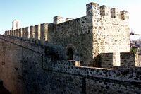
Elvas is among the finest examples of intensive usage of the trace italienne (star fort) in military architecture, and has been a World Heritage Site since 30 June 2012. The inscribed site name is Garrison Border Town of Elvas and its Fortifications.
التاريخ
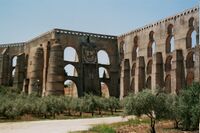
Elvas lies on a hill 8 كيلومتر (5.0 mi) northwest of the Guadiana river. The Amoreira Aqueduct 6 كيلومتر (3.7 mi) long supplies the city with pure water; it was begun early in the 15th century and completed in 1622. For some distance it includes four tiers of superimposed arches, with a total height of 40 متر (130 ft).[3]
It was wrested from the Moors by Afonso I of Portugal in 1166 but the city was temporarily recaptured before its final occupation by the Portuguese in 1226. In 1570 it became an episcopal see, the Roman Catholic Diocese of Elvas, until 1818. The late Gothic Our Lady of the Assumption Cathedral, which has many traces of Moorish influence in its architecture, dates from the reign of Manuel I of Portugal (1495–1521).[3]
It was defended by seven bastions and the two forts of Santa Luzia and the Nossa Senhora da Graça Fort.[3] From 1642 it was the chief frontier fortress south of the Tagus, which withstood sieges by the Spanish in 1659, 1711, and 1801.[4] Elvas was the site of the Battle of the Lines of Elvas in 1659, during which the garrison and citizens of the city assisted in the rout of a Spanish Army.[citation needed] The Napoleonic French under Marshal Junot took it in March 1808 during the Peninsular War, but evacuated it in August after the conclusion of the Convention of Sintra.[4] The fortress of Campo Maior 15 كيلومتر (9.3 mi) to the northeast is known for its Napoleonic era siege by the French and relief by the British under Marshal Beresford in 1811, an exploit commemorated in a ballad by Sir Walter Scott.[3]
موقع اليونسكو
The Garrison Border Town of Elvas and its Fortifications were added to the list of UNESCO World Heritage Sites in 2012.[5]
The site, extensively fortified from the 17th to 19th centuries, represents the largest bulwarked dry ditch system in the world. Within its walls, the town contains barracks and other military buildings as well as churches and monasteries. While Elvas contains remains dating back to the 10th century, its fortification began during the Portuguese Restoration War. The fortifications played a major role in the Battle of the Lines of Elvas in 1659. The fortifications were designed by Dutch Jesuit Padre João Piscásio Cosmander and represent the best surviving example of the Dutch school of fortifications anywhere. The site consists the following:
- Amoreira Aqueduct, built to withstand long sieges.
- Historic Centre
- Fort of Santa Luzia and the covered way
- Nossa Senhora da Graça Fort
- Fortlet of São Mamede
- Fortlet of São Pedro
- Fortlet of São Domingos
المناخ
| بيانات المناخ لـ إلواس، درجات الحرارة المعتادة والقصوى 1971-2000 | |||||||||||||
|---|---|---|---|---|---|---|---|---|---|---|---|---|---|
| الشهر | ينا | فب | مار | أبر | ماي | يون | يول | أغس | سبت | أكت | نوف | ديس | السنة |
| القصوى القياسية °س (°ف) | 21.0 (69.8) |
23.0 (73.4) |
30.8 (87.4) |
32.0 (89.6) |
35.0 (95.0) |
42.5 (108.5) |
44.0 (111.2) |
42.0 (107.6) |
41.5 (106.7) |
33.0 (91.4) |
29.2 (84.6) |
22.0 (71.6) |
44.0 (111.2) |
| متوسط القصوى اليومية °س (°ف) | 13.4 (56.1) |
15.3 (59.5) |
18.3 (64.9) |
20.1 (68.2) |
23.8 (74.8) |
29.3 (84.7) |
33.6 (92.5) |
33.4 (92.1) |
29.7 (85.5) |
23.2 (73.8) |
17.6 (63.7) |
14.2 (57.6) |
22.7 (72.8) |
| المتوسط اليومي °س (°ف) | 8.6 (47.5) |
10.2 (50.4) |
12.3 (54.1) |
14.1 (57.4) |
17.3 (63.1) |
21.7 (71.1) |
25.1 (77.2) |
24.8 (76.6) |
22.2 (72.0) |
17.4 (63.3) |
12.5 (54.5) |
9.7 (49.5) |
16.3 (61.4) |
| متوسط الدنيا اليومية °س (°ف) | 3.8 (38.8) |
5.0 (41.0) |
6.3 (43.3) |
8.0 (46.4) |
10.8 (51.4) |
14.1 (57.4) |
16.6 (61.9) |
16.3 (61.3) |
14.7 (58.5) |
11.5 (52.7) |
7.5 (45.5) |
5.3 (41.5) |
10.0 (50.0) |
| الصغرى القياسية °س (°ف) | −7.0 (19.4) |
−5.0 (23.0) |
−2.0 (28.4) |
−1.5 (29.3) |
1.5 (34.7) |
6.0 (42.8) |
10.0 (50.0) |
8.0 (46.4) |
4.0 (39.2) |
−1.0 (30.2) |
−4.5 (23.9) |
−5.5 (22.1) |
−7.0 (19.4) |
| متوسط تساقط الأمطار mm (inches) | 63.1 (2.48) |
54.6 (2.15) |
39.6 (1.56) |
51.2 (2.02) |
44.0 (1.73) |
23.6 (0.93) |
4.8 (0.19) |
2.6 (0.10) |
25.6 (1.01) |
58.6 (2.31) |
75.1 (2.96) |
92.6 (3.65) |
535.4 (21.09) |
| Average precipitation days (≥ 0.1 mm) | 10.9 | 9.2 | 8.0 | 9.3 | 8.1 | 4.1 | 1.3 | 1.3 | 4.0 | 8.9 | 9.0 | 11.2 | 85.3 |
| Mean monthly ساعات سطوع الشمس | 154.3 | 161.8 | 212.1 | 224.6 | 275.4 | 316.2 | 366.6 | 339.2 | 252.2 | 198.6 | 164.8 | 129.4 | 2٬795٫2 |
| Source: Instituto de Meteorologia[6] | |||||||||||||
| بيانات المناخ لـ ڤيلا فرناندو، درجات الحرارة المعتادة والقصوى 1971-2000: 360 متر | |||||||||||||
|---|---|---|---|---|---|---|---|---|---|---|---|---|---|
| الشهر | ينا | فب | مار | أبر | ماي | يون | يول | أغس | سبت | أكت | نوف | ديس | السنة |
| القصوى القياسية °س (°ف) | 20.0 (68.0) |
22.6 (72.7) |
27.5 (81.5) |
31.0 (87.8) |
34.5 (94.1) |
42.0 (107.6) |
42.5 (108.5) |
40.6 (105.1) |
41.2 (106.2) |
33.6 (92.5) |
26.5 (79.7) |
22.5 (72.5) |
42.5 (108.5) |
| متوسط القصوى اليومية °س (°ف) | 12.2 (54.0) |
13.8 (56.8) |
16.7 (62.1) |
18.3 (64.9) |
22.3 (72.1) |
27.8 (82.0) |
32.0 (89.6) |
31.8 (89.2) |
28.1 (82.6) |
21.7 (71.1) |
16.3 (61.3) |
13.1 (55.6) |
21.2 (70.1) |
| المتوسط اليومي °س (°ف) | 8.4 (47.1) |
9.7 (49.5) |
11.7 (53.1) |
13.0 (55.4) |
16.2 (61.2) |
20.6 (69.1) |
23.9 (75.0) |
23.6 (74.5) |
21.4 (70.5) |
16.6 (61.9) |
12.2 (54.0) |
9.6 (49.3) |
15.6 (60.0) |
| متوسط الدنيا اليومية °س (°ف) | 4.7 (40.5) |
5.6 (42.1) |
6.7 (44.1) |
7.7 (45.9) |
10.1 (50.2) |
13.3 (55.9) |
15.7 (60.3) |
15.5 (59.9) |
14.6 (58.3) |
11.5 (52.7) |
8.1 (46.6) |
6.0 (42.8) |
10.0 (49.9) |
| الصغرى القياسية °س (°ف) | −5.0 (23.0) |
−5.0 (23.0) |
−1.0 (30.2) |
−1.0 (30.2) |
2.0 (35.6) |
6.0 (42.8) |
9.0 (48.2) |
8.0 (46.4) |
4.0 (39.2) |
1.5 (34.7) |
−0.5 (31.1) |
−3.0 (26.6) |
−5.0 (23.0) |
| متوسط تساقط الأمطار mm (inches) | 64.3 (2.53) |
54.6 (2.15) |
41.7 (1.64) |
54.0 (2.13) |
39.2 (1.54) |
23.2 (0.91) |
7.6 (0.30) |
4.5 (0.18) |
23.8 (0.94) |
58.6 (2.31) |
72.9 (2.87) |
88.2 (3.47) |
532.6 (20.97) |
| Average precipitation days (≥ 0.1 mm) | 11.0 | 9.2 | 7.6 | 9.1 | 7.1 | 4.0 | 1.5 | 1.0 | 3.9 | 8.2 | 9.3 | 10.1 | 82 |
| Source: Instituto de Meteorologia[7] | |||||||||||||
أعلام
المدن الشقيقة
 Badajoz, Extremadura, Spain
- Olivenza, Extremadura, Spain
 Campo Maior, Alentejo, Portugal
معرض صور
-
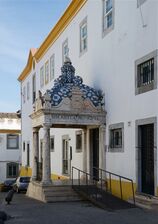 Entrance of the Municipal Library of Elvas
 -
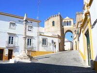
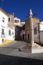 A pillory in the city of Elvas
 -
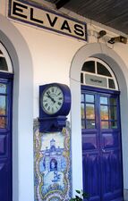 Elvas Station
 -
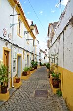
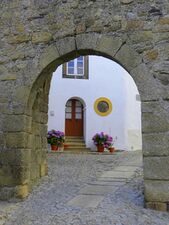 Typical features
 -
-
 City walls
 -
-
 Elvas, Portugal
 -
-
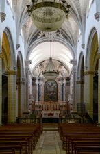 Inside of a local Catholic church
 -
 Square of Santa Clara
 -
 Elvas, Alentejo
 -
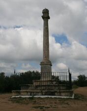 Monument commemorating the 1659 Battle of the Lines of Elvas


.jpg&filetimestamp=20210308172804&)


.jpg&filetimestamp=20210308172812&)

انظر أيضا
مراجع
- ^ Instituto Nacional de Estatística
- ^ "Áreas das freguesias, concelhos, distritos e país". Archived from the original on 2018-11-05. Retrieved 2018-11-05.
- ^ أ ب ت ث Chisholm 1911, p. 300.
- ^ أ ب Chisholm 1911, p. 301.
- ^ "Garrison Border Town of Elvas and its Fortifications".
- ^ "Monthly Averages for Elvas (1971–2000)" (PDF). IPMA.
- ^ "Monthly Averages for Vila Fernando (1971–2000)" (PDF). IPMA.
Alto Douro Wine Region • Historic Centre of Angra do Heroísmo, Azores • Batalha Monastery • Convent of Christ, Tomar • Cultural Landscape of Sintra • Historic Centre of Évora • Historic Centre of Guimarães • Landscape of the Pico Island Vineyard Culture • Laurisilva of Madeira • Alcobaça Monastery • Monastery of the Hieronymites and Belém Tower, Lisbon • المركز التاريخي في پورتو • Prehistoric Rock-Art Sites in the Côa Valley |  | |
- Pages using gadget WikiMiniAtlas
- Short description is different from Wikidata
- Coordinates on Wikidata
- Portugal articles needing attention
- Articles containing برتغالية-language text
- Pages using Lang-xx templates
- Articles with unsourced statements from September 2019
- World Heritage Sites in Portugal
- الواس
- أماكن مأهولة في محافظة بورتاليجري
- بلديات البرتغال
- بلديات محافظة بورتاليجري
- مدن الپرتغال
- مواقع التراث العالمي في البرتغال