إيل دِيـَر

إيل دِيـَر (Îles d'Hyères ؛ تـُنطق: [il djɛːʁ])، وتُعرف أيضاً بإسم إيل دور (Îles d'Or ؛ [il dɔʁ])، هي مجموعة من أربع جزر في البحر المتوسط مقابل Hyères في إقليم ڤار في جنوب شرق فرنسا.
الجزر
بمساحة مجمعة قدرها 29 كم²، تضم إيل دِيـَر الجزر التالية:
- Porquerolles - 1،254 هكتار (3،100 acre), an extension of the Giens peninsula
- Port-Cros - 650 هكتار (1،600 acre), the most mountainous, part of Port-Cros National Park, noted for rare flora and as a bird refuge
- Île du Bagaud - 45 هكتار (110 acre), part of the same national park, and without permitted access
- Île du Levant - 900 هكتار (2،200 acre), mostly for military use, partly a long-established naturist community centered on the privately-owned village of Héliopolis
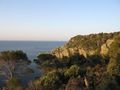
Porquerolles
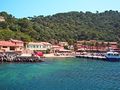
Port-Cros
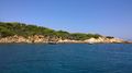
Île du Bagaud
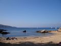
Île du Levant

.jpg&filetimestamp=20201014120018&)
.jpg&filetimestamp=20201014120017&)

الهامش
Wikivoyage has a travel guide for إيل دِيـَر.
الكلمات الدالة:
This article contains content from Wikimedia licensed under CC BY-SA 4.0. Please comply with the license terms.