مقاطعة مرسر، إلينوي
مقاطعة مرسر إنگليزية: Mercer County هي إحدى المقاطعات في ولاية إلينوي في الولايات المتحدة الأمريكية.
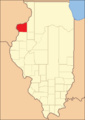
Mercer County at the time of its creation in 1825
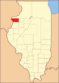
Mercer County in 1827, reduced to its present borders


Mercer County | |
|---|---|
 | |
 Location within the U.S. state of Illinois | |
 موقع Illinois ضمن الولايات المتحدة | |
| الإحداثيات: Coordinates: 41°12′N 90°44′W / 41.20°N 90.74°W | |
| البلد | |
| State | |
| تأسست | January 13, 1825 |
| السمِيْ | Hugh Mercer |
| Seat | Aledo |
| Largest city | Aledo |
| المساحة | |
| • الإجمالي | 569 ميل² (1٬470 كم²) |
| • البر | 561 ميل² (1٬450 كم²) |
| • الماء | 7٫5 ميل² (19 كم²) 1.3% |
| التعداد (2010) | |
| • الإجمالي | 16٬434 |
| • Estimate (2018) | 15٬601 |
| • الكثافة | 29/sq mi (11/km2) |
| منطقة التوقيت | UTC−6 (Central) |
| • الصيف (التوقيت الصيفي) | UTC−5 (CDT) |
| Congressional district | 17th |
| الموقع الإلكتروني | www |
. . . . . . . . . . . . . . . . . . . . . . . . . . . . . . . . . . . . . . . . . . . . . . . . . . . . . . . . . . . . . . . . . . . . . . . . . . . . . . . . . . . . . . . . . . . . . . . . . . . . . . . . . . . . . . . . . . . . . . . . . . . . . . . . . . . . . . . . . . . . . . . . . . . . . . . . . . . . . . . . . . . . . . . .
الجغرافيا
According to the U.S. Census Bureau, the county has a total area of 569 square miles (1,470 km2), of which 561 square miles (1,450 km2) is land and 7.5 square miles (19 km2) (1.3%) is water.[1]
المناخ
| Aledo, Illinois | ||||||||||||||||||||||||||||||||||||||||||||||||||||||||||||
|---|---|---|---|---|---|---|---|---|---|---|---|---|---|---|---|---|---|---|---|---|---|---|---|---|---|---|---|---|---|---|---|---|---|---|---|---|---|---|---|---|---|---|---|---|---|---|---|---|---|---|---|---|---|---|---|---|---|---|---|---|
| جدول الطقس (التفسير) | ||||||||||||||||||||||||||||||||||||||||||||||||||||||||||||
| ||||||||||||||||||||||||||||||||||||||||||||||||||||||||||||
| ||||||||||||||||||||||||||||||||||||||||||||||||||||||||||||
In recent years, average temperatures in the county seat of Aledo have ranged from a low of 11 °F (−12 °C) in January to a high of 84 °F (29 °C) in July, although a record low of −30 °F (−34 °C) was recorded in February 1905 and a record high of 113 °F (45 °C) was recorded in July 1936. Average monthly precipitation ranged from 1.27 inches (32 mm) in January to 4.43 inches (113 mm) in June.[2]
. . . . . . . . . . . . . . . . . . . . . . . . . . . . . . . . . . . . . . . . . . . . . . . . . . . . . . . . . . . . . . . . . . . . . . . . . . . . . . . . . . . . . . . . . . . . . . . . . . . . . . . . . . . . . . . . . . . . . . . . . . . . . . . . . . . . . . . . . . . . . . . . . . . . . . . . . . . . . . . . . . . . . . . .
الطرق الرئيسية
المقاطعات المجاورة
- Rock Island County - north
- Henry County - east
- Knox County - southeast
- Henderson County - south
- Warren County - south
- Des Moines County, Iowa - southwest
- Louisa County, Iowa - west
السكان
| التعداد التاريخي | |||
|---|---|---|---|
| التعداد | Pop. | %± | |
| 1830 | 26 | — | |
| 1840 | 2٬352 | 8٬946٫2% | |
| 1850 | 5٬246 | 123�0% | |
| 1860 | 15٬042 | 186٫7% | |
| 1870 | 18٬769 | 24٫8% | |
| 1880 | 19٬502 | 3٫9% | |
| 1890 | 18٬545 | −4٫9% | |
| 1900 | 20٬945 | 12٫9% | |
| 1910 | 19٬723 | −5٫8% | |
| 1920 | 18٬800 | −4٫7% | |
| 1930 | 16٬641 | −11٫5% | |
| 1940 | 17٬701 | 6٫4% | |
| 1950 | 17٬374 | −1٫8% | |
| 1960 | 17٬149 | −1٫3% | |
| 1970 | 17٬294 | 0٫8% | |
| 1980 | 19٬286 | 11٫5% | |
| 1990 | 17٬290 | −10٫3% | |
| 2000 | 16٬957 | −1٫9% | |
| 2010 | 16٬434 | −3٫1% | |
| 2018 (تق.) | 15٬601 | [3] | −5٫1% |
| U.S. Decennial Census[4] 1790-1960[5] 1900-1990[6] 1990-2000[7] 2010-2013[8] | |||
التجمعات
المدن
Villages
- Alexis
- Joy
- Matherville
- North Henderson
- Reynolds (Part in Rock Island County)
- Seaton
- Sherrard
- Viola
- Windsor
Unincorporated communities
Townships
Mercer County is divided into fifteen townships:
Politics
Historically, Mercer County was a solidly Republican Yankee-influenced county, and before the Republican Party existed a stronghold of the Whig Party. The county never voted for a Democratic presidential candidate until Lyndon Johnson’s 1964 landslide over Barry Goldwater – the solitary break in Whig and Republican dominance occurring in 1912 when the GOP was mortally split and Progressive Theodore Roosevelt carried the county over conservative incumbent President William Howard Taft. After Johnson’s victory in the county, Mercer voted to being Republican between 1968 and 1984, but Reagan’s landslide in that election saw a swing to the Democrats that was capitalized upon by Michael Dukakis to carry the county in 1988. Between then and 2012, Mercer was solidly Democratic, but concern over declining economic opportunities in the “Rust Belt” caused a dramatic swing to populist Republican Donald Trump in 2016. Trump’s performance was the best by a Republican since Richard Nixon's 3,000-plus-county landslide in 1972.
Mercer County is located in Illinois's 17th Congressional District and is currently represented by Democrat Cheri Bustos. Within the Illinois House of Representatives, the county is located in the 74th district and is currently represented by Republican Daniel Swanson. The county is located in the 37th district of the Illinois Senate, and is currently represented by Republican Chuck Weaver.
| السنة | الجمهوري | الديمقراطي | حزب ثالث | |||
|---|---|---|---|---|---|---|
| رقم. | % | رقم. | % | رقم. | % | |
| 2020 | 5,418 | 60٫78% | 3,280 | 36٫80% | 216 | 2٫42% |
| 2016 | 4,807 | 56٫39% | 3,071 | 36٫02% | 647 | 7٫59% |
| 2012 | 3,876 | 45٫24% | 4,507 | 52٫60% | 185 | 2٫16% |
| 2008 | 3,833 | 43٫21% | 4,887 | 55٫10% | 150 | 1٫69% |
| 2004 | 4,405 | 49٫09% | 4,512 | 50٫28% | 57 | 0٫64% |
| 2000 | 3,688 | 44٫34% | 4,400 | 52٫90% | 230 | 2٫77% |
| 1996 | 2,688 | 34٫04% | 4,278 | 54٫17% | 931 | 11٫79% |
| 1992 | 2,983 | 34٫93% | 3,990 | 46٫72% | 1,567 | 18٫35% |
| 1988 | 3,683 | 46٫45% | 4,204 | 53٫02% | 42 | 0٫53% |
| 1984 | 4,907 | 54٫97% | 3,982 | 44٫61% | 38 | 0٫43% |
| 1980 | 5,144 | 56٫18% | 3,361 | 36٫71% | 651 | 7٫11% |
| 1976 | 4,816 | 53٫62% | 4,090 | 45٫54% | 76 | 0٫85% |
| 1972 | 5,452 | 60٫98% | 3,477 | 38٫89% | 11 | 0٫12% |
| 1968 | 4,844 | 56٫33% | 3,143 | 36٫55% | 613 | 7٫13% |
| 1964 | 4,220 | 48٫90% | 4,410 | 51٫10% | 0 | 0�00% |
| 1960 | 5,582 | 61٫60% | 3,476 | 38٫36% | 3 | 0٫03% |
| 1956 | 5,732 | 65٫82% | 2,969 | 34٫10% | 7 | 0٫08% |
| 1952 | 6,416 | 70٫53% | 2,679 | 29٫45% | 2 | 0٫02% |
| 1948 | 5,267 | 62٫55% | 3,117 | 37٫02% | 36 | 0٫43% |
| 1944 | 5,667 | 63٫12% | 3,277 | 36٫50% | 34 | 0٫38% |
| 1940 | 6,336 | 62٫09% | 3,830 | 37٫53% | 38 | 0٫37% |
| 1936 | 5,028 | 50٫87% | 4,751 | 48٫07% | 105 | 1٫06% |
| 1932 | 4,436 | 50٫21% | 4,309 | 48٫77% | 90 | 1٫02% |
| 1928 | 5,699 | 70٫59% | 2,316 | 28٫69% | 58 | 0٫72% |
| 1924 | 5,618 | 68٫30% | 1,699 | 20٫66% | 908 | 11٫04% |
| 1920 | 5,531 | 74٫58% | 1,574 | 21٫22% | 311 | 4٫19% |
| 1916 | 5,308 | 58٫93% | 3,430 | 38٫08% | 270 | 3�00% |
| 1912 | 959 | 19٫20% | 1,602 | 32٫07% | 2,435 | 48٫74% |
| 1908 | 2,871 | 57٫51% | 1,777 | 35٫60% | 344 | 6٫89% |
| 1904 | 3,230 | 63٫65% | 1,386 | 27٫31% | 459 | 9٫04% |
| 1900 | 3,304 | 59٫39% | 2,110 | 37٫93% | 149 | 2٫68% |
| 1896 | 3,120 | 56٫48% | 2,329 | 42٫16% | 75 | 1٫36% |
| 1892 | 2,470 | 52٫70% | 1,975 | 42٫14% | 242 | 5٫16% |
. . . . . . . . . . . . . . . . . . . . . . . . . . . . . . . . . . . . . . . . . . . . . . . . . . . . . . . . . . . . . . . . . . . . . . . . . . . . . . . . . . . . . . . . . . . . . . . . . . . . . . . . . . . . . . . . . . . . . . . . . . . . . . . . . . . . . . . . . . . . . . . . . . . . . . . . . . . . . . . . . . . . . . . .
See also
Footnotes
- ^ خطأ استشهاد: وسم
<ref>غير صحيح؛ لا نص تم توفيره للمراجع المسماةcensus-density - ^ أ ب "Monthly Averages for Aledo, Illinois". The Weather Channel. Retrieved 2011-01-27.
- ^ "Population and Housing Unit Estimates". Retrieved November 3, 2019.
- ^ "U.S. Decennial Census". United States Census Bureau. Retrieved July 7, 2014.
- ^ "Historical Census Browser". University of Virginia Library. Retrieved July 7, 2014.
- ^ "Population of Counties by Decennial Census: 1900 to 1990". United States Census Bureau. Retrieved July 7, 2014.
- ^ "Census 2000 PHC-T-4. Ranking Tables for Counties: 1990 and 2000" (PDF). United States Census Bureau. Retrieved July 7, 2014.
- ^ خطأ استشهاد: وسم
<ref>غير صحيح؛ لا نص تم توفيره للمراجع المسماةQF - ^ Leip, David. "Dave Leip's Atlas of U.S. Presidential Elections". uselectionatlas.org. Retrieved 2018-11-11.
Further reading
- William C. Ives, "Abraham Lincoln in Mercer County, Illinois, 1832, 1834, 1858," Journal of the Illinois State Historical Society, vol. 101 (Fall–Winter 2008), pp. 329–347.
- History of Mercer and Henderson Counties, Together with Biographical Matter, Statistics, Etc. Chicago: H.H. Hill and Company, 1882.