مقاطعة رذرفورد، كارولاينا الشمالية
Rutherford County | |
|---|---|
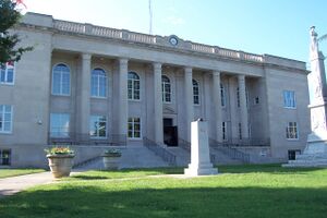
 Rutherford County Courthouse in Rutherfordton | |
| الشعار: Small Town Friendly | |
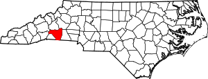
 الموقع ضمن ولاية North Carolina | |
 موقع North Carolina ضمن الولايات المتحدة | |
| الإحداثيات: 35°24′N 81°55′W / 35.40°N 81.92°W | |
| البلد | |
| State | |
| تأسست | 1779 |
| السمِيْ | Griffith Rutherford |
| Seat | Rutherfordton |
| أكبر town | Forest City |
| المساحة | |
| • الإجمالي | 566 ميل² (1٬470 كم²) |
| • البر | 564 ميل² (1٬460 كم²) |
| • الماء | 1٫7 ميل² (4 كم²) 0.3%% |
| التعداد | |
| • Estimate (2021) | 64٬586 |
| • الكثافة | 114٫5/sq mi (44٫2/km2) |
| منطقة التوقيت | UTC−5 (Eastern) |
| • الصيف (التوقيت الصيفي) | UTC−4 (EDT) |
| Congressional districts | 10th، 11th |
| الموقع الإلكتروني | rutherfordcountync |
مقاطعة روذرفورد إنگليزية: Rutherford County هي إحدى مقاطعات ولاية كارولاينا الشمالية في الولايات المتحدة الأمريكية. مركز المقاطعة أو مقعدها هي مدينة رذرفوردتون. تأسست هذه المقاطعة سنة 1779. أصل هذه المقاطعة يأتي من: مقاطعة تريون.
الجغرافيا
المقاطعات المجاورة
- McDowell County - north
- Burke County - northeast
- Cleveland County - east
- Cherokee County, South Carolina - south
- Spartanburg County, South Carolina - south
- Polk County - southwest
- Henderson County - west
- Buncombe County - northwest
السكان
| التعداد | Pop. | ملاحظة | %± |
|---|---|---|---|
| 1790 | 7٬808 | — | |
| 1800 | 10٬753 | 37٫7% | |
| 1810 | 13٬202 | 22٫8% | |
| 1820 | 15٬351 | 16٫3% | |
| 1830 | 17٬557 | 14٫4% | |
| 1840 | 19٬202 | 9٫4% | |
| 1850 | 13٬550 | −29٫4% | |
| 1860 | 11٬573 | −14٫6% | |
| 1870 | 13٬121 | 13٫4% | |
| 1880 | 15٬198 | 15٫8% | |
| 1890 | 18٬770 | 23٫5% | |
| 1900 | 25٬101 | 33٫7% | |
| 1910 | 28٬385 | 13٫1% | |
| 1920 | 31٬426 | 10٫7% | |
| 1930 | 40٬452 | 28٫7% | |
| 1940 | 45٬577 | 12٫7% | |
| 1950 | 46٬356 | 1٫7% | |
| 1960 | 45٬091 | −2٫7% | |
| 1970 | 47٬337 | 5�0% | |
| 1980 | 53٬787 | 13٫6% | |
| 1990 | 56٬918 | 5٫8% | |
| 2000 | 62٬899 | 10٫5% | |
| 2010 | 67٬810 | 7٫8% | |
| 2020 | 64٬444 | −5�0% | |
| 2021 (تق.) | 64٬586 | [1] | 0٫2% |
| U.S. Decennial Census[2] 1790-1960[3] 1900-1990[4] 1990-2000[5] 2010-2013[6] | |||
التجمعات
البلدات
- Bostic
- Ellenboro
- Forest City (largest town)
- Lake Lure
- Ruth
- Rutherfordton (county seat)
- Spindale
القرى
Census-designated places
Unincorporated communities
- Alexander Mills (merged with Forest City)
- Corinth
- Harris
- Hopewell
- Mount Vernon
- Union Mills
- Sandy Mush
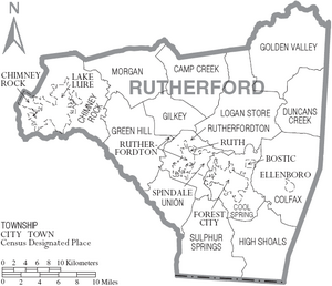
Townships
- Camp Creek
- Chimney Rock
- Colfax
- Cool Spring
- Duncans Creek
- Gilkey
- Golden Valley
- Green Hill
- High Shoals
- Logan Store
- Morgan
- Rutherfordton
- Sulphur Springs
- Union
السياسة
Rutherford is currently a powerfully Republican county. No Democratic presidential candidate has carried Rutherford County since Jimmy Carter did so in 1976. Before 1928 when Herbert Hoover won it, however, the county was a clear-cut part of the Democratic "Solid South".
| السنة | الجمهوري | الديمقراطي | حزب ثالث | |||
|---|---|---|---|---|---|---|
| رقم. | % | رقم. | % | رقم. | % | |
| 2020 | 24,891 | 72٫30% | 9,135 | 26٫53% | 403 | 1٫17% |
| 2016 | 21,871 | 72٫16% | 7,512 | 24٫79% | 924 | 3٫05% |
| 2012 | 18,954 | 66٫04% | 9,374 | 32٫66% | 374 | 1٫30% |
| 2008 | 18,769 | 65٫35% | 9,641 | 33٫57% | 310 | 1٫08% |
| 2004 | 16,343 | 66٫28% | 8,184 | 33٫19% | 131 | 0٫53% |
| 2000 | 13,755 | 63٫34% | 7,697 | 35٫44% | 264 | 1٫22% |
| 1996 | 9,792 | 52٫73% | 7,162 | 38٫57% | 1,617 | 8٫71% |
| 1992 | 9,748 | 47٫95% | 7,855 | 38٫64% | 2,726 | 13٫41% |
| 1988 | 10,337 | 59٫73% | 6,926 | 40٫02% | 43 | 0٫25% |
| 1984 | 11,369 | 62٫23% | 6,862 | 37٫56% | 37 | 0٫20% |
| 1980 | 8,363 | 49٫29% | 8,315 | 49٫01% | 288 | 1٫70% |
| 1976 | 6,718 | 39٫24% | 10,361 | 60٫52% | 42 | 0٫25% |
| 1972 | 9,506 | 68٫80% | 4,140 | 29٫97% | 170 | 1٫23% |
| 1968 | 7,785 | 46٫11% | 4,622 | 27٫38% | 4,476 | 26٫51% |
| 1964 | 7,115 | 42٫72% | 9,541 | 57٫28% | 0 | 0�00% |
| 1960 | 8,993 | 51٫25% | 8,554 | 48٫75% | 0 | 0�00% |
| 1956 | 8,200 | 53٫22% | 7,208 | 46٫78% | 0 | 0�00% |
| 1952 | 8,387 | 51٫96% | 7,755 | 48٫04% | 0 | 0�00% |
| 1948 | 4,342 | 36٫95% | 5,992 | 51�00% | 1,416 | 12٫05% |
| 1944 | 4,698 | 38٫90% | 7,379 | 61٫10% | 0 | 0�00% |
| 1940 | 4,204 | 32٫16% | 8,869 | 67٫84% | 0 | 0�00% |
| 1936 | 4,830 | 32٫77% | 9,911 | 67٫23% | 0 | 0�00% |
| 1932 | 4,448 | 34٫65% | 8,336 | 64٫93% | 54 | 0٫42% |
| 1928 | 5,762 | 58٫16% | 4,146 | 41٫84% | 0 | 0�00% |
| 1924 | 3,897 | 43٫17% | 5,101 | 56٫51% | 29 | 0٫32% |
| 1920 | 4,015 | 44٫04% | 5,101 | 55٫96% | 0 | 0�00% |
| 1916 | 1,871 | 43٫35% | 2,445 | 56٫65% | 0 | 0�00% |
| 1912 | 82 | 2٫14% | 2,180 | 56٫93% | 1,567 | 40٫92% |
أشخاص بارزون
- Smoky Burgess, record-setting major league baseball player
- Bryan Coker, 12th President of Maryville College
- Walter Dalton, former lieutenant governor of North Carolina (in office 2009–2013)
- Tim Earley, American poet
- Pleasant Daniel Gold (1833–1920), American publisher and clergyman
- Kay Hooper, best-selling author
- Robert McNair, Owner Houston Texans
- Burl Noggle, American historian born in Rutherford County in 1924
- Richard O'Sullivan, screenwriter and filmmaker
انظر أيضاً
- National Register of Historic Places listings in Rutherford County, North Carolina
- North Carolina State Parks
المراجع
- ^ cite "U.S. Census Bureau QuickFacts: Rutherford County, North Carolina". www.census.gov. Retrieved April 30, 2022
- ^ "U.S. Decennial Census". United States Census Bureau. Retrieved يناير 19, 2015.
- ^ "Historical Census Browser". University of Virginia Library. Retrieved يناير 19, 2015.
- ^ Forstall, Richard L., ed. (مارس 27, 1995). "Population of Counties by Decennial Census: 1900 to 1990". United States Census Bureau. Retrieved يناير 19, 2015.
- ^ "Census 2000 PHC-T-4. Ranking Tables for Counties: 1990 and 2000" (PDF). United States Census Bureau. أبريل 2, 2001. Retrieved يناير 19, 2015.
- ^ "State & County QuickFacts". United States Census Bureau. Archived from the original on يوليو 17, 2011. Retrieved أكتوبر 29, 2013.
- ^ Leip, David. "Dave Leip's Atlas of U.S. Presidential Elections". uselectionatlas.org. Retrieved مارس 17, 2018.
وصلات خارجية
- Rutherford County official website
- NCGenWeb Rutherford County- free genealogy resources for the county
- Rutherford County Tourism Information
- Genealogical Society of Old Tryon County

|
Burke County | McDowell County | Buncombe County | 
|
| Cleveland County | Henderson County | |||
| Cherokee County, South Carolina | Spartanburg County, South Carolina | Polk County |
الكلمات الدالة:
?
تصنيفات:
- Pages using gadget WikiMiniAtlas
- Short description matches Wikidata
- Use mdy dates from November 2021
- Short description is different from Wikidata
- Coordinates on Wikidata
- مقاطعات North Carolina
- Articles containing إنگليزية-language text
- Pages using Lang-xx templates
- Rutherford County, North Carolina
- تأسيسات 1779 في كارولاينا الشمالية
- أماكن مأهولة تأسست في 1779
- مقاطعات أپلاشيا


