جزر ديزرتاز

| Ilhas Desertas | |
| أرخبيل (Ilha) | |
 قوارب شراعية زائرة في خليج المحمية الطبيعية إيلياز ديزرتاز، الجزر غير مأهولة.
| |
| Official name: Ilhas Desertas | |
| Name origin: desertas، صيغة الجمع في اللغة البرتغالية لكلمة مهجورة | |
| البلد | |
|---|---|
| إقليم ذاتي | |
| الموقع | Tore-Madeira Ridge, الصفيحة التكتونية الأفريقية, المحيط الأطلسي |
| أرخبيل | ماديرا |
| أعلى نقطة | Boqueiro Norte |
| - الموقع | ديزرتا گراندي, سانتا كروز دا ماديرا |
| - المنسوب | 442 m (1،450 ft) |
| - الإحداثيات | 32°32′46″N 16°31′31″W / 32.54611°N 16.52528°W |
| أوطى نقطة | سطح البحر |
| - الموقع | المحيط الأطلسي |
| - المنسوب | 0 m (0 ft) |
| الطول | 22.34 km (14 mi), شمال غرب-جنوب شرق |
| الاتساع | 1.34 km (1 mi), شمال-جنوب |
| المساحة | 14.21 km2 (5 sq mi) |
| Biomes | معتدل, متوسطي |
| الجيولوجيا | بازلت قلوي, تفرا, Trachyte, Trachybasalt |
| Orogeny | نشاط بركاني |
| الفترة | هولوسين، پليوسين |
 | |
| الإحصائيات من INE (2001)؛ التفاصيل الجغرافية من المعهد الجغرافي البرتغالي (2010) | |
جزر ديزرتاز (برتغالية: Ilhas Desertas؛ أصد: [ˈiʎɐʒ ðɨˈzɛɾtɐʃ]، "الجزر المهجورة"؛ إنگليزية: Desertas Islands) هي أرخبيل صغير، في منطقة مكرونيزيا في المحيط الأطلسي. ويتبعون إقليم ماديرا الذاتي البرتغالية، وهم جزء من أرخبيل ماديرا.
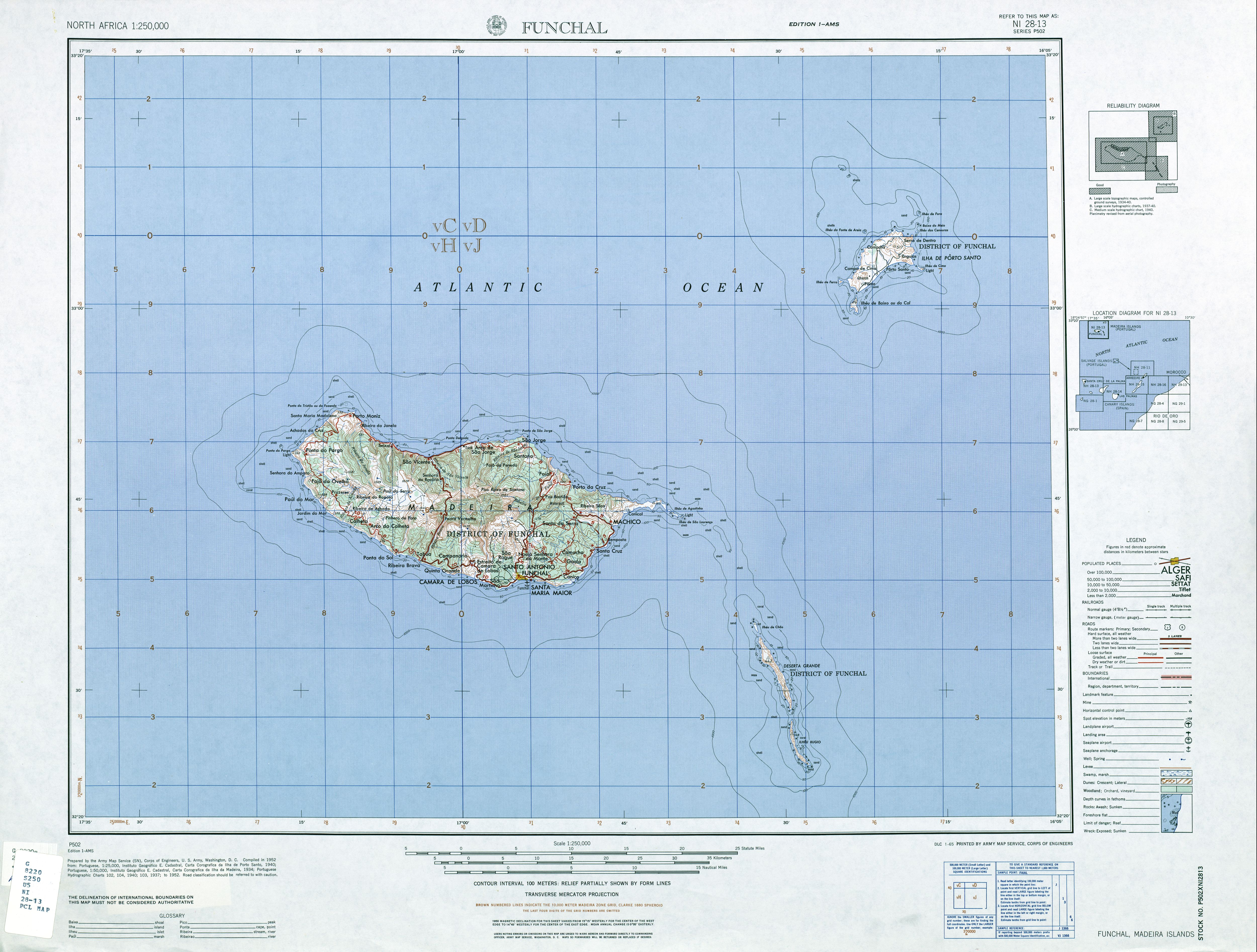
ويقع الأرخبيل مقابل ساحل المغرب، تقريباً بين جزيرة ماديرا وجزر الكناري. وتقع جزيرة ديزرتا الكبرى على بعد 25 كم جنوب شرق الطرف الشرقي لـجزيرة ماديرا، پورتا دى ساو لورنسو.
الجغرافيا
أرخبيل جزر ديزرتاز هو سلسلة من ثلاث جزر طويلة وضيقة تمتد لمسافة شمال/جنوب قدرها 22.3 كم. جزر ديزرتاز، من الشمال إلى الجنوب مع مساحة تقريبية، هم:
| الجزيرة | المساحة (كم²) | الارتفاع (م) |
|---|---|---|
| جـُزَيرة تشاو | 1 | 98 |
| ديزرتا گراندي | 10 | 442 |
| بوگيو | 3 | 348 |
| الإجمالي | 14.21 | 442 |

الادارة
ادارياً، الجزر هي جزء من بلدية سانتا كروز في ماديرا، وتقع ضمن Santa Cruz الأبرشية المدنية.
The islands are a designated Portuguese nature reserve. A licence is needed to land there.
التاريخ الطبيعي
Though close to the main island of Madeira, where the islands can often be seen on the horizon, the geology of the Ilhas Desertas is starkly different. The high, long, and rocky islands of the group are barren of soil, and the only wildlife consists of about sixteen species of birds, including eight species of seabirds, and a scarce population of feral goats, rabbits, and rodents, brought from Portugal by the mariners who first touched the rocky shores. Native species of tarantula, as well as reptiles, also exist in the fragile and arid ecosystem.
The only inhabitable island, with its own water source, is Deserta Grande. This water is however murky and scarce, and all historical attempts to colonise the island failed due to the impracticability of communal agriculture.
وثمة مستعمرة صغيرة لفقمات الراهب المتوسطية على شواطئ الجزر، ومنذ 1990 the islands have been a nature reserve for their protection. Although in 1998 the colony numbered only eight, by today, the population numbers roughly twenty. The only human presence is the permanent wardens, geologists, occasional boaters, and the few research stations on the islands.
انظر أيضاًٍ
وصلات خارجية
 Media related to Desertas Islands at Wikimedia Commons
- Topographic map of the Desertas Islands (1:250,000)

- Pages using geobox2 unit with unknown unit type
- صفحات المعرفة التي فيها البلد أو التقسيم غير معروف
- Pages using gadget WikiMiniAtlas
- Pages using deprecated coordinates format
- Geobox usage tracking for other type
- Articles containing برتغالية-language text
- Pages using Lang-xx templates
- Articles containing إنگليزية-language text
- Islands of the Autonomous Region of Madeira
- جزر مكرونيزيا
- Nature reserves in Portugal
- جزر غير مأهولة في البرتغال