خريطة

الخريطة هي صورة لكوكب الأرض أو جزء منه. تحتلف الخرائط عن الصور الجوية في أنها تحتوي على معلومات وتوضيح للمناطق الجغرافية. يسمى العلم المختص برسم خرائط بعلم الخرائط. اليوم يمكن أن ترسم الخرائط بواسطة أنظمة GIS الحاسوبية، وهي قواعد بيانية تحتوي على معلومات حول ما يوجد في الخرائط.
إذا كانت الخرائط مطبوعة على الورق أو ظاهرة على شاشة الحاسوب، فهي تكون صورة خيالية للعالم. السبب هو أن الكرة الأرضية ليست مسطحة الشكل كما هو الحال مع الورق أو الشاشات. الخرائط الوحيدة التي لا تعتبر خيالية هي الخرائط الموجودة على هيئة كرة. والخرئط غالباً ما تكون ثنائية الأبعاد (عدا خرائط الكرات). لم يكن من الممكن رسم خرائط ثلاثية الأبعاد إلا بواسطة الحاسوب.
لكل خريطة مقياس يحدد نسبة الصورة إلى الأبعاد الواقعية. بطبيعة الحال كلما زاد حجم الخريطة زاد عدد التفاصيل التي تحتويها. هناك عدة أنواع للخرائط، أبرزها الخرائط السياسية والجغرافية. الخرائط السياسية تركز على توضيح الحدود بين الدول. أما الخرائط الجغرافية فهي تختص بتوضيح مظاهر الجغرافيا الطبيعية في المناطق.
التاريخ

الخرائط الجغرافية

أنواع الخرائط

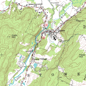
Maps of the world or large areas are often either 'political' or 'physical'. The most important purpose of the political map is to show territorial borders; the purpose of the physical is to show features of geography such as mountains, soil type or land use including infrastructure such as roads, railroads and buildings. Topographic maps show elevations and relief with contour lines or shading. Geological maps show not only the physical surface, but characteristics of the underlying rock, fault lines, and subsurface structures.
الخرائط الإلكترونية
قائمة أنواع الخرائط
- Aeronautical chart
- Atlas
- Cadastral map
- Climatic map
- Geologic map
- Nautical map
- Physical map
- Political map
- Relief map
- Resource map
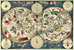
- Star map
- Street map
- Thematic map
انظر أيضاً
- عام
- تصميم وأنواع الخرائط
- تاريخ الخرائط
- مواضيع متعلقة
المراجع
- الهامش
- ببليوگرافيا
- David Buisseret, ed., Monarchs, Ministers and Maps: The Emergence of Cartography as a Tool of Government in Early Modern Europe. Chicago: University of Chicago Press, 1992, ISBN 0-226-07987-2
- Denis E. Cosgrove (ed.) Mappings. Reaktion Books, 1999 ISBN 1-86189-021-4
- Freeman, Herbert, Automated Cartographic Text Placement. White paper.
- Ahn, J. and Freeman, H., “A program for automatic name placement,” Proc. AUTO-CARTO 6, Ottawa, 1983. 444–455.
- Freeman, H., “Computer Name Placement,” ch. 29, in Geographical Information Systems, 1, D.J. Maguire, M.F. Goodchild, and D.W. Rhind, John Wiley, New York, 1991, 449–460.
- Mark Monmonier, How to Lie with Maps, ISBN 0-226-53421-9
- O'Connor, J.J. and E.F. Robertson, The History of Cartography. Scotland : St. Andrews University, 2002.
وصلات خارجية
- International Cartographic Association (ICA), the world body for mapping and GIScience professionals
- Geography and Maps, an Illustrated Guide, by the staff of the U.S. Library of Congress.
- The History of Cartography Project at the University of Wisconsin, a comprehensive research project in the history of maps and mapping


