الألپ الجوليانية
| Julian Alps | |
|---|---|
 The Eastern Julian Alps and Mount Triglav | |
| أعلى نقطة | |
| القمة | Triglav |
| الارتفاع | 2،864 m (9،396 ft) |
| الإحداثيات | 46°23′N 13°50′E / 46.383°N 13.833°E |
| الجغرافيا | |
.png&filetimestamp=20220331024442&) Julian Alps (in red) within the Alps. The borders of the range according to Alpine Club classification of the Eastern Alps | |
| Countries | Italy and Slovenia |
| نطاق الإحداثيات | 46°20′N 13°45′E / 46.333°N 13.750°E |
| السلسلة الأم | Southern Limestone Alps |
الألپ الجوليانية (Slovene: Julijske Alpe؛ إيطالية: Alpi Giulie؛ Venetian: Alpe Jułie؛ فريولية: Alps Juliis؛ إنگليزية: Julian Alps) هي سلسلة جبال في Southern Limestone Alps that stretch from northeastern Italy to Slovenia, where they rise to 2,864 m at Mount Triglav, the highest peak in Slovenia and of the former Yugoslavia. A large part of the Julian Alps is included in Triglav National Park. The second highest peak of the range, the 2,755 m high Jôf di Montasio, lies in Italy.[1]
The Julian Alps cover an estimated 4,400 km2 (of which 1,542 km2 lies in Italy). They are located between the Sava Valley and Canale Valley. They are divided into the Eastern and Western Julian Alps.
الاسم
The Julian Alps were known in antiquity as Alpe Iulia, and also attested as Alpes Juliana ح. AD 670, Alpis Julia ح. 734, and Alpes Iulias in 1090.[2] Like the municipium of Forum Julii (now Cividale del Friuli) at the foot of the mountains, the range was named after Julius Caesar of the Julian clan,[2][3] perhaps due to a road built by Julius Caesar and completed by Augustus.[4]
الألپ الجوليانية الشرقية

There are many peaks in the Eastern Julian Alps over 2,000 m high, and they are mainly parts of ridges. The most prominent peaks are visible by their height and size. There are high plateaus on the eastern border, such as Pokljuka, Mežakla, and Jelovica.
The main peaks by height are the following:
- Triglav 2،864 m (9،396 ft) – the highest mountain and on the coat of arms of Slovenia
- Škrlatica 2،740 m (8،990 ft)
- Mangart 2،679 m (8،789 ft)
- Jalovec 2،645 m (8،678 ft)
- Razor 2،601 m (8،533 ft)
- Kanjavec 2،568 m (8،425 ft)
- Prisojnik 2،546 m (8،353 ft)
- Rjavina 2،532 m (8،307 ft)
- Prestreljenik 2،499 m (8،199 ft)
- Špik 2،472 m (8،110 ft)
- Tosc 2،275 m (7،464 ft)
- Krn 2،244 m (7،362 ft)
الألپ الجوليانية الغربية
The Western Julian Alps cover a much smaller area, and are located mainly in Italy. Only the Kanin group lies in part in Slovenia. The main peaks by height are:
- Jôf di Montasio (2،755 m أو 9،039 ft)
- Jôf Fuart (2،666 m أو 8،747 ft)
- High Mount Kanin (2،582 m أو 8،471 ft)

الممرات
.jpg&filetimestamp=20220331024437&)
Important passes of the Julian Alps are:
- The Vršič Pass, 1,611 m (5,826 feet), links the Sava and Soča valleys. It is the highest mountain road pass in Slovenia.
- The Predil Pass (links Villach via Tarvisio and Bovec to Gorizia), paved road 1,156 m (3,792 feet)
- The Pontebba Pass (links Villach via Tarvisio and Pontebba to Udine), railway, paved road, 797 m (2,615 feet)
معرض صور
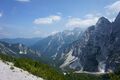
The Julian Alps, from the Vršič Pass
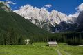
The Julian Alps with Prisojnik and Razor
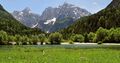
The Krnica Valley near Kranjska Gora
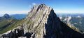
Modeon del Montasio seen from Cima di Terrarossa


.jpg&filetimestamp=20220331024437)
انظر أيضاً
- الألپ الجوليانية الإيطالية
- Triglav Lakes Valley
- List of mountains in Slovenia
- Slovenian Mountain Hiking Trail
المراجع
- ^ "Julian Alps | mountains, Europe".
- ^ أ ب Snoj, Marko (2009). Etimološki slovar slovenskih zemljepisnih imen. Ljubljana: Modrijan. pp. 44–45.
- ^ Smith, William (1857). Dictionary of Greek and Roman Geography, vol. 2. Boston: Little, Brown, and Company. p. 102.
- ^ Waring, Samuel Miller (1819). The Traveller's Fire-Side; a Series of Papers on Switzerland, the Alps, Etc. London: Baldwin, Cradock, and Joy. pp. 30–31.
وصلات خارجية
- Pages using gadget WikiMiniAtlas
- Short description is different from Wikidata
- Coordinates on Wikidata
- Articles containing Slovene-language text
- Pages using Lang-xx templates
- Articles containing إيطالية-language text
- Articles containing Venetian-language text
- Articles containing فريولية-language text
- Articles containing إنگليزية-language text
- الألپ الجوليانية
- Mountain ranges of the Alps
- Mountain ranges of Italy
- Mountain ranges of Slovenia
- Mountains of Friuli-Venezia Giulia
- Mountains of the Slovene Littoral
- Southern Limestone Alps
- Landforms of Upper Carniola
- Biosphere reserves of Slovenia
- Natura 2000 in Slovenia