إستروشن
إستروشن
Истаравшан استروشن | |
|---|---|
 | |
 إستروشن Location in Tajikistan | |
| الإحداثيات: 39°54′39″N 69°00′23″E / 39.91083°N 69.00639°E | |
| البلد | |
| الولاية | ولاية صغد |
| المنسوب | 992 m (3٬255 ft) |
| التعداد (2020)[2] | |
| • المدينة | 273٬500 |
| • Urban | 65٬600 |
| منطقة التوقيت | UTC+5 |
| Official languages | |
إسـْتـَرَوْشـَن (بالطاجيكية: Истаравшан؛ فارسية: استروشن؛ روسية: Истаравшан؛ Istaravshan) هي مدينة في ولاية صغد في طاجيكستان. في 2000، غيرت الحكومة الطاجيكية اسم المدينة من الاسم السابق أورتپه (Uroteppa ؛ بالطاجيكية: Ӯротеппа؛ Ura-Tyube؛ روسية: Ура-Тюбе).
The city lies in the northern foothills of the Turkistan mountain range, 78 kilometers southwest of Khujand, on the main road connecting Tajikistan's two largest cities, Khujand and Dushanbe. Bordered by Uzbekistan in the north and west, and Kyrgyzstan in the east, the territorial area of Istaravshan stretches 1,830 square kilometers, and with an administrative population of 273,500 people, the majority of its citizens (76%) live in the outlying countryside.[2]
Istaravshan is a city-museum, one of central Asia's oldest towns of commerce and crafts. 2002 saw the 2.500 anniversary of the city celebrated by Istaravshan. The city is one of three proposed locations of ancient Cyropolis built on the north-eastern outskirts of the Achaemenid Empire by the king Cyrus in the 6th century B.C.[4]

المناخ
Istaravshan has a cold semi-arid climate (Köppen climate classification BSk). There is more rainfall in winter than in summer. The average annual temperature in Istaravshan is 12.2 °C (54.0 °F). About 485 mm (19.09 in) of precipitation falls annually.
| بيانات المناخ لـ Istaravshan | |||||||||||||
|---|---|---|---|---|---|---|---|---|---|---|---|---|---|
| الشهر | ينا | فب | مار | أبر | ماي | يون | يول | أغس | سبت | أكت | نوف | ديس | السنة |
| متوسط القصوى اليومية °س (°ف) | 3.2 (37.8) |
5.3 (41.5) |
11.2 (52.2) |
18.9 (66.0) |
24.5 (76.1) |
30.2 (86.4) |
32.8 (91.0) |
31.4 (88.5) |
26.7 (80.1) |
19.1 (66.4) |
11.2 (52.2) |
5.4 (41.7) |
18.3 (65.0) |
| متوسط الدنيا اليومية °س (°ف) | −5.0 (23.0) |
−3.4 (25.9) |
1.8 (35.2) |
7.6 (45.7) |
11.5 (52.7) |
15.3 (59.5) |
17.3 (63.1) |
15.3 (59.5) |
10.3 (50.5) |
5.3 (41.5) |
0.7 (33.3) |
−2.5 (27.5) |
6.2 (43.1) |
| متوسط تساقط الأمطار mm (inches) | 56 (2.2) |
53 (2.1) |
81 (3.2) |
80 (3.1) |
60 (2.4) |
12 (0.5) |
6 (0.2) |
1 (0.0) |
6 (0.2) |
38 (1.5) |
38 (1.5) |
54 (2.1) |
370 (14.6) |
| Source: climate-data | |||||||||||||
التقسيمات

,_10-11th_century_CE,_Istaravchan,_Tajikistan,_National_Museum_of_Antiquities_of_Tajikistan_(941-3442).jpg&filetimestamp=20221105145805&)
Before ca. 2018, Istaravshan was the seat of Istaravshan District, which covered the rural part of the present city of Istaravshan.[5] The city of Istaravshan covers Istaravshan proper and ten jamoats.[2] These are as follows:[6]
| Jamoat | Population (Jan. 2015)[6] |
|---|---|
| Chorbogh | 16,488 |
| Guli Surkh | 42,582 |
| Javkandak | 10,200 |
| Nijoni | 10,350 |
| Nofaroj | 10,875 |
| Poshkent | 19,746 |
| Qal'achai Kalon | 15,433 |
| Qalaibaland | 9,820 |
| Sabriston (Frunze) | 16,822 |
| Zarhalol | 30,683 |
صور


إستروشن على طوابع بريدية
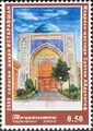
Stamps of Tajikistan, 2002
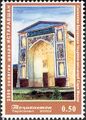
Stamps of Tajikistan, 2002
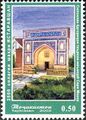
Stamps of Tajikistan, 2002
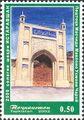
Stamps of Tajikistan, 2002


,_10-11th_century_CE,_Istaravchan,_Tajikistan,_National_Museum_of_Antiquities_of_Tajikistan_(941-3442).jpg&filetimestamp=20221105145805)
أشخاص بارزون
- Ulmas Mirsaidovich Mirsaidov (born 1945), theoretical chemist and professor
انظر أيضاً
المراجع
- ^ "Climate of Vose'". Weatherbase.com. Retrieved 2 August 2014.
- ^ أ ب ت "Population of the Republic of Tajikistan as of 1 January 2020" (PDF) (in الروسية). Statistics office of Tajikistan. Retrieved 3 October 2020.
- ^ "КОНСТИТУЦИЯ РЕСПУБЛИКИ ТАДЖИКИСТАН". prokuratura.tj. Parliament of Tajikistan. Retrieved 9 January 2020.
- ^ "Istaravshan". Retrieved March 19, 2021.
{{cite web}}: CS1 maint: url-status (link) - ^ "Population of the Republic of Tajikistan as of 1 January 2015" (PDF) (in الروسية). Statistics office of Tajikistan. Archived from the original (PDF) on 2 July 2015. Retrieved 3 October 2020.
- ^ أ ب Jamoat-level basic indicators, United Nations Development Programme in Tajikistan, accessed 3 October 2020
| الترتيب | الولاية | التعداد | |||||||
|---|---|---|---|---|---|---|---|---|---|
 دوشنبه  خوجند |
1 | دوشنبه | دوشنبه | 846,400 |  قرغانتپه  كولاب | ||||
| 2 | خوجند | صغد | 181,600 | ||||||
| 3 | قرغانتپه | خطلان | 110,800 | ||||||
| 4 | كولاب | خطلان | 105,500 | ||||||
| 5 | إستروشن | صغد | 64,600 | ||||||
| 6 | إسفرة | صغد | 59,500 | ||||||
| 7 | Vahdat | النواحي التابعة للجمهورية | 55,000 | ||||||
| 8 | Tursunzoda | النواحي التابعة للجمهورية | 53,700 | ||||||
| 9 | Konibodom | صغد | 52,200 | ||||||
| 10 | Panjakent | صغد | 42,800 | ||||||
العاصمة: خوجند | |||||||||||||||||||||||||
|  | ||||||||||||||||||||||||
|
| |||||||||||||||||||||||||
| |||||||||||||||||||||||||
- Pages using gadget WikiMiniAtlas
- CS1 الروسية-language sources (ru)
- CS1 maint: url-status
- Short description is different from Wikidata
- Articles containing طاجيكية-language text
- Articles containing فارسية-language text
- Coordinates on Wikidata
- Articles containing روسية-language text
- Pages using Lang-xx templates
- أماكن مأهولة في ولاية صغد
- Jamoats of Tajikistan