تحليل مكاني
(تم التحويل من Spatial analysis)

التحليل المكاني Spatial analysis أو الإحصائيات المكانية spatial statistics، تشمل أي تقنيات رسمية تدرس الكيانات باستخدام خصائصها الطبولوجية، الهندسية، أو الجغرافية. يشمل التحليل المكاني مختلف التقنيات، لا يزال الكثير منها في مراحل تطوره المبكرة، ويستخدم المنهاج التحليلة المهتلفة ويطبقها في مجالات مختلفة من الفلك، ودراساته الخاصة بوضع المجرات في الكون، حتى هندسة تصنيع الرقاقات، واستخدامها لوغاريتمات "المكان والمسار" لبناء هياكل الأسلاك المعقدة. بشكل أكثر تحديداً، التحليل المكني هو التقنية المطبقة على الهياكل في النطاق الإنساني، ومن أشهرها تحليل البيانات الجغرافية.
تاريخ التحليل المكاني
قضايا أساسية في التحليل المكاني
التوصيف المكني

التبعية المكانية أو الارتباط الذاتي
التدرج
أخذ العينات
الأخطاء الشائعة في التحليل المكني
-
 Britain measured using a long yardstick
 -
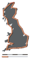 Britain measured using a medium yardstick
 -
 Britain measured using a short yardstick


حلول للقضايا الأساسية

أنواع التحليل المكاني
تحليل البيانات المكنية
التبعية الذاتية المكانية
الاستيفاء المكاني
الانحدار المكاني
التفاعل المكاني
المحاكاة والنمذجة
الاحصائيات الجغرافية متعددة النقاط
علم المعلومات الجغرافية والتحليل المكاني

المحتوى
انظر أيضاً
- موضوعات عامة
- رسم الخرائط
- Complete spatial randomness
- GeoComputation
- Geospatial predictive modeling
- Dimensionally Extended nine-Intersection Model (DE-9IM)
- علم المعلومات الجغرافية
- إحصائيات رياضية
- Modifiable Areal Unit Problem
- Spatial autocorrelation
- Spatial relation
- تطبيقات محددة
- نظم المعلومات الجغرافية
- Geodemographic segmentation
- Visibility analysis
- Fuzzy architectural spatial analysis
- Suitability analysis
- Extrapolation domain analysis
- Geoinformatics
- Boundary problem (in spatial analysis)
- Spatial epidemiology
- Spatial econometrics
المصادر
قراءات إضافية
This "further reading" section may need cleanup. (June 2014) (Learn how and when to remove this template message) |
- Abler, R., J. Adams, and P. Gould (1971) Spatial Organization–The Geographer's View of the World, Englewood Cliffs, NJ: Prentice-Hall.
- Anselin, L. (1995) "Local indicators of spatial association – LISA". Geographical Analysis, 27, 93–115.
- Banerjee, S., B.P. Carlin and A.E. Gelfand (2004). Hierarchical Modeling and Analysis for Spatial Data. Taylor and Francis: Chapman and Hall/CRC Press.
- Benenson, I. and P. M. Torrens. (2004). Geosimulation: Automata-Based Modeling of Urban Phenomena. Wiley.
- Fotheringham, A. S., C. Brunsdon and M. Charlton (2000) Quantitative Geography: Perspectives on Spatial Data Analysis, Sage.
- Fotheringham, A. S. and M. E. O'Kelly (1989) Spatial Interaction Models: Formulations and Applications, Kluwer Academic
- Fotheringham, A. S.; Rogerson, P. A. (1993). "GIS and spatial analytical problems". International Journal of Geographical Information Systems. 7: 3–19. doi:10.1080/02693799308901936.
- Goodchild, M. F. (1987). "A spatial analytical perspective on geographical information systems" (PDF). International Journal of Geographical Information Systems. 1: 327–44. doi:10.1080/02693798708927820.
- MacEachren, A. M. and D. R. F. Taylor (eds.) (1994) Visualization in Modern Cartography, Pergamon.
- Levine, N. (2010). CrimeStat: A Spatial Statistics Program for the Analysis of Crime Incident Locations. Version 3.3. Ned Levine & Associates, Houston, TX and the National Institute of Justice, Washington, DC. Ch. 1-17 + 2 update chapters [1]
- Miller, H. J. (2004). "Tobler's First Law and spatial analysis". Annals of the Association of American Geographers. 94: 284–289. doi:10.1111/j.1467-8306.2004.09402005.x.
- Miller, H. J. and J. Han (eds.) (2001) Geographic Data Mining and Knowledge Discovery, Taylor and Francis.
- O'Sullivan, D. and D. Unwin (2002) Geographic Information Analysis, Wiley.
- Parker, D. C., S. M. Manson, M.A. Janssen, M. J. Hoffmann and P. Deadman (2003) "Multi-agent systems for the simulation of land-use and land-cover change: A review". Annals of the Association of American Geographers, 93, 314–337.
- White, R.; Engelen, G. (1997). "Cellular automata as the basis of integrated dynamic regional modelling". Environment and Planning B: Planning and Design. 24: 235–246. doi:10.1068/b240235.
- Scheldeman, X. & van Zonneveld, M. (2010). Training Manual on Spatial Analysis of Plant Diversity and Distribution. Bioversity International.
{{cite book}}: CS1 maint: multiple names: authors list (link) - Fisher MM, Leung Y (2001) Geocomputational Modelling: techniques and applications. Springer Verlag, Berlin
- Fotheringham, S; Clarke, G; Abrahart, B (1997). "Geocomputation and GIS". Transactions in GIS. 2: 199–200. doi:10.1111/j.1467-9671.1997.tb00010.x.
- Openshaw S and Abrahart RJ (2000) GeoComputation. CRC Press
- Diappi L (2004) Evolving Cities: Geocomputation in Territorial Planning. Ashgate, England
- Longley PA, Brooks SM, McDonnell R, Macmillan B (1998), Geocomputation, a primer. John Wiley and Sons, Chichester
- Ehlen, J; Caldwell, DR; Harding, S (2002). "GeoComputation: what is it?". Comput Environ and Urban Syst. 26: 257–265. doi:10.1016/s0198-9715(01)00047-3.
- Gahegan, M (1999). "What is Geocomputation?". Transaction in GIS. 3: 203–206. doi:10.1111/1467-9671.00017.
- Murgante B., Borruso G., Lapucci A. (2009) "Geocomputation and Urban Planning" Studies in Computational Intelligence, Vol. 176. Springer-Verlag, Berlin.
- Fischer M., Leung Y. (2010) "GeoComputational Modelling: Techniques and Applications" Advances in Spatial Science. Springer-Verlag, Berlin.
- Murgante B., Borruso G., Lapucci A. (2011) "Geocomputation, Sustainability and Environmental Planning" Studies in Computational Intelligence, Vol. 348. Springer-Verlag, Berlin.
- Tahmasebi, P.; Hezarkhani, A.; Sahimi, M. (2012). "Multiple-point geostatistical modeling based on the cross-correlation functions" (PDF). Computational Geosciences. 16 (3): 779–79742. doi:10.1007/s10596-012-9287-1.
- Tóth, G., Kincses, Á., Nagy, Z., (2014) European Spatial Structure LAP LAMBERT Academic Publishing, ISBN 978-3-659-64559-4, DOI:10.13140/2.1.1560.2247
وصلات خارجية
- ICA Commission on Geospatial Analysis and Modeling
- An educational resource about spatial statistics and geostatistics
- A comprehensive guide to principles, techniques & software tools
- Social and Spatial Inequalities
- National Center for Geographic Information and Analysis (NCGIA)
- International Cartographic Association (ICA), the world body for mapping and GIScience professionals