طافية

الطافية Buoy، هي جسم طاف مثبتٌ في الماء لإرشاد السُفن وتوجيهها. وتساعد الطَّافيات قباطنة السُفن وملاحيها في القيادة بأمان، في المرافئ والأنهار وأيِّ مياه أخرى. ويوجد في كافة السُفن خرائط توضح أماكن الطَّافيات وأنواعها.
الاستخدامات
وتُستخدم أنواع مختلفة من الطَّافيات لأغراض متعدِّدة. وعلى سبيل المثال، في الولايات المتحدة، يشير اللون الأحمر إلى الجانب الأيمن من القناة، للسفينة التي تدخل إلى الميناء، بينما تشير الطَّافيات الخضراء إلى الجانب الأيسر من القناة. وتشير الطَّافيات الحمراء والبيضاء إلى المياه المأمونة. أما الطَّافيات ذات اللَّون الماسي البرتقالي المشرب بالبياض، فتعتبر علامات إرشادية، أو علامات تنظيمية. وقد تُستخدم للتدليل على منطقة خطر، أو منطقة محظورة. وتعني الطَّافيات الصفراء إمكانيَّة وجود معلومات خاصة على الخرائط، أو التعرف عليها من مصادر أخرى. وتشير الطَّافيات الخضراء ـ في بعض البلاد الأخرى ـ إلى الجانب الصحيح، فيما تشير الطَّافيات الحمراء إلى الجانب الأيسر لخط مائي عائد.
الأنواع
وتختلف الطَّافيات من حيث الشكل أيضًا؛ فهناك طافية ضخمة، مخروطية الشكل، ومعدنية، وتشبه الأسطوانات، وذات قمم مسطحة. كما أن هناك طافية، مستديرة في الوسط، ومستدقة عند كل طرف، وتشبه المخروط، فالطَّافيات الخضراء عوَّامات مخروطية الشكل ومعدنية، وتشبه الأسطوانات، وذات قمم مسطحة. أما الطَّافيات الحمراء فهي مستديرة في الوسط ومستدقة عند كل طرف، وتشبه المخروط. ويوجد بكلا النوعين ـ أحيانًا ـ أحزمة أفقيَّة لتوضِّح القناة الأفضل. ويعني اللَّون الأخضر فوق اللَّون الأحمر أن القناة المفضلة تقع على الجهة اليمنى. ويشير اللون الأحمر فوق اللَّون الأخضر، إلى أن القناة الأفضل تقع على الجهة اليسرى.
أما الطَّافيات الحمراء والبيضاء فهي علامات كرويَّة أو علامة حمراء كرويَّة بالقمة. وتوجد ـ عادة ـ عند مدخل القناة. وتكون الطَّافيات ـ عادة ـ مرقمة. فللطافيات الخضراء أرقام فردية، بينما للطافيات الحمراء أرقام زوجية.
وللطَّافيات الأخرى أنوار، ولهذا تمكن رؤيتها في الليل. ويرشد لون أنوارها، وطول ومضاتها ربان السفينة إلى مغزى الإشارات. كما أن هناك نوعًا من الطافيات، ترسل إشارتها مع صفير، أو صوت جرس قرصي الشكل، أو ناقوس. وميزة الطَّافيات المصوِّتة، تتمثَّل في أن إشاراتها يمكن أن تُسمَع عندما يكون الطقس كثير الضباب، ويعوق رؤية الطَّافيات المضيئة.
- Sea mark - aids pilotage by marking a maritime channel, hazard and administrative area to allow boats and ships to navigate safely.
- طافية انقاذ - used as a life saving buoy designed to be thrown to a person in the water to provide buoyancy. Usually has a connecting line allowing the casualty to be pulled to the rescuer
- Submarine communication buoys - used for release in case of emergencies or for communication
- DAN buoy - has several meanings:
- A large maritime navigational aid providing a platform for light and radio beacons
- A lifebuoy with a flags used on yachts and smaller pleasure craft
- A temporary marker buoy used during Danish seine fishing to mark the anchor position of a net.
- A temporary marker buoy set by danlayers during minesweeping operations to indicate the boundaries of swept paths, swept areas, known hazards, and other locations or reference points.
- A temporary marker buoy set to mark a man overboard position.
- طافية صوتية - يستخدمها الطائرات المضادة للغواصات للكشف عن الغواصات بواسطة سونار
- Surface Marker Buoy - taken on dives by scuba divers to mark their position underwater
- Decompression buoy - deployed by submerged scuba divers to mark their position underwater whilst doing decompression stops
- Shot buoy - used to mark dive sites for the boat safety cover of scuba divers so that the divers can descend to the dive site more easily in conditions of low visibility or tidal currents and more safely do decompression stops on their ascent
- Fairway Buoy is a navigational buoy which marks the entrance to a channel or a nearby landfall
- lateral marker buoy
- Mooring buoys - used to keep one end of a mooring cable or chain on the water's surface so that ships or boats can tie on to it
- Tripping buoys - used to keep one end of a 'tripping line' on the water's surface so that a stuck anchor can more easily be freed
- طافية طقس - equipped to measure weather parameters such as air temperature, barometric pressure, wind speed and direction and to report these data via satellite radio links such as the purpose-built Argos System or commercial satellite phone networks to meteorological centres for use in forecasting and climate study. May be anchored (moored buoys) or allowed to drift (drifting buoys) in the open ocean currents. Position is calculated by the satellite.
- Tsunami buoys - anchored buoys that can detect sudden changes in undersea water pressure are used as part of tsunami warning systems in the Pacific Tsunami Warning Center and Indian Oceans.
- Spar buoy - a tall, thin buoy that floats upright in the water, e.g. R/P FLIP.
- Profiling buoy - specialized models which adjust buoyancy so that they will sink at a controlled rate to 2,000 metres below the surface while measuring sea temperatures and salinity. After at time, typically 10 days, the buoy returns to the surface, transmits its data via satellite, and then sinks again. See Argo (oceanography).
- Ice marking buoys - used for marking ice holes in frozen lakes and rivers, so that snowmobiles do not drive over the holes.
- Marker buoys - used in naval warfare, particularly anti-submarine warfare, is a light-emitting or smoke-emitting, or both, marker using some kind of pyrotechnic to provide the flare and smoke. It is commonly a 3-inch (76 mm) diameter device about 20 inches (500 mm) long that is set off by contact with seawater and floats on the surface. Some markers extinguish after a set period and others are made to sink.
- Lobster trap buoys - brightly colored buoys used for the marking of lobster trap locations so the person lobster fishing can find their lobster traps. Each lobster fisherman has his or her own color markings or registration numbers so they know which ones are theirs. They are only allowed to haul their own traps and must display their buoy color or license number on their boat so law enforcement officials know what they should be hauling. The buoys are brightly colored with highly visible numbers so they can be seen under conditions when there is poor visibility like rain, fog, sea smoke, etc.
- الطافية ممتطية الأمواج - used to measure the movement of the water surface as a wave train. The wave train is analysed to determine statistics like the significant wave height and period, and wave direction.
- Target buoy - used to simulate target (like small boat) in live fire exercise by naval and coastal forces, usually targeted by weapons (medium size) like HMG's, rapid fire cannons (20 or so mm), autocannons (bigger ones up to 40 and 57mm) and also anti-tank rockets.
- Wreck buoy - a buoy to mark a wrecked ship to warn other ships to keep away because of unseen hazards.
- Self-Locating Datum Marker Buoy (SLDMB) - A 70% scale Coastal Ocean Dynamics Experiment (CODE)/Davis-style oceanographic surface drifter with drogue vanes between 30 and 100 cm deep.[1] This particular surface drifter is designed specifically for deployment from a U.S. Coast Guard vessel or airframe for search and rescue. Since the SLDMB has a very small surface area above the ocean surface and a high underwater surface area, there is very little leeway in response to the direct forcing of winds and waves.[2]
- The space buoy is a common element in science fiction that refers to a stationary object in outer space that provides navigation data or warnings about that particular area.
- Buoy Racing is the most prevalent form of yacht racing
معرض الصور
-
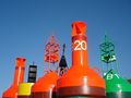 Several different buoys at a storage depot.
 -
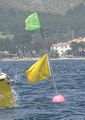 A buoy used as turn marker for sailing races.
 -
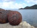 Old iron buoys, most likely for mooring.
 -
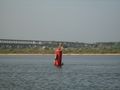 Children playing on a buoy in the Volga
 -
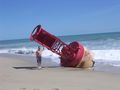 A buoy beached at Sebastian Inlet State Park.
 -
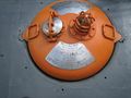 Emergency buoy of the Swedish submarine Nordkaparen


انظر أيضاً
- American Practical Navigator
- Captain John Bury
- Coast Pilots
- Baba Booey
- Day beacon
- International Arctic Buoy Program
- Lateral mark
- Light List
- List of Lights
- Lightvessel
- Lighthouse
المصادر
- ^ [METOCEAN. (2008). METOCEAN SLDMB: Operating & Maintenance Manual (Version 3.0 ed.) Retrieved from http://www.metocean.com.
- ^ [Bang, I., Mooers, C. N. K., Haus, B., Turner, C., Lewandowski, M. (2007). Technical Report: Surface Drifter Advection and Dispersion in the Florida Current Between Key West and Jacksonville, Florida. Technical Report.].