ملف:Michigan Basin 2.jpg
Michigan_Basin_2.jpg (357 × 360 بكسل حجم الملف: 47 كيلوبايت، نوع MIME: image/jpeg)
وصف قصير
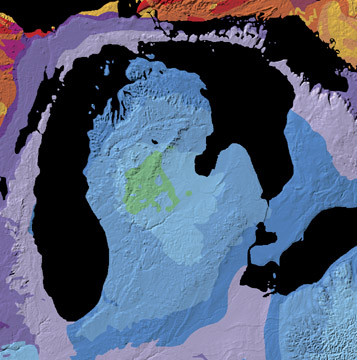
A geological map of the Michigan Basin.
Source: Michigan Basin Archive copy at the Internet Archive, The North American Tapestry of Time and Terrain, United States Department of the Interior. Text from this web page follows below.
A giant incomplete bull's-eye is centered on the state of Michigan. Radiating outward to Ohio, Indiana, Illinois, Wisconsin, and Ontario, this annular pattern outlines the Michigan Basin. The Basin is a bowl-shaped structure of uncertain origin that contains over 2.5 miles (4 km) of inward-dipping Paleozoic strata and a veneer of Jurassic sedimentary rocks. This curious basin is located in the less tectonically-active interior of the continent, bordered by the Appalachian and Rocky Mountains. It subsided rapidly from Cambrian to Silurian time and filled with shallow-water marine sediments, some of which contain deposits of petroleum, coal, and salt.
ترخيص
تاريخ الملف
اضغط على زمن/تاريخ لرؤية الملف كما بدا في هذا الزمن.
| زمن/تاريخ | صورة مصغرة | الأبعاد | مستخدم | تعليق | |
|---|---|---|---|---|---|
| حالي | ★ مراجعة معتمدة 16:37، 22 نوفمبر 2023 | | 357 × 360 (47 كيلوبايت) | Pastakhov (نقاش | مساهمات) | Upload https://upload.wikimedia.org/wikipedia/commons/5/5a/Michigan_Basin_2.jpg |
لا يمكنك استبدال هذا الملف.
وصلات
لا يوجد صفحات تصل لهذه الصورة.