ملف:Internet map 1024.jpg

حجم هذه المعاينة: 600 × 600 بكسل. البعد الآخر: 1٬280 × 1٬280 بكسل.
الملف الأصلي (1٬280 × 1٬280 بكسل حجم الملف: 1٫27 ميجابايت، نوع MIME: image/jpeg)
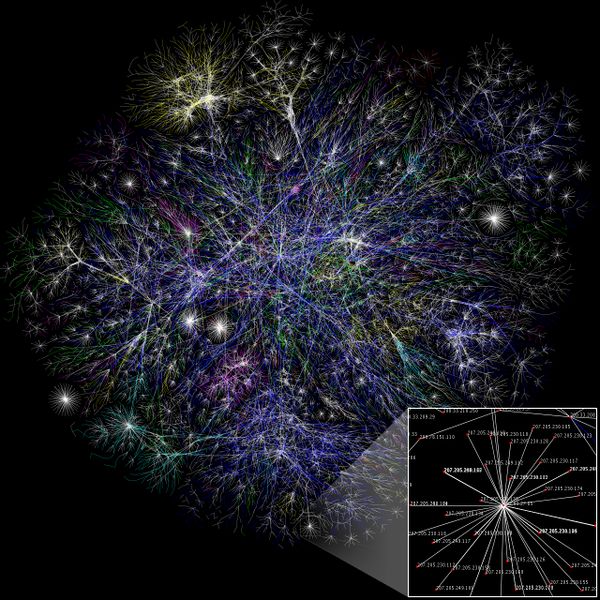
خريطة الإنترنت، طوّرها Matt Britt
خريطة جزئية للإنترنت مبنية على بيانات 15 يناير 2005 الموجودة في opte.org. Each line is drawn between two nodes,
representing two IP addresses. The length of the lines are indicative of the delay between those two nodes. This graph represents less than 30% of the Class C networks reachable by the data collection program in early 2005. Lines are color-coded according to their corresponding RFC 1918 allocation as follows: Dark blue: net, ca, us Green: com, org Red: mil, gov, edu Yellow: jp, cn, tw, au, de Magenta: uk, it, pl, fr Gold: br, kr, nl White: unknown
تاريخ الملف
اضغط على زمن/تاريخ لرؤية الملف كما بدا في هذا الزمن.
| زمن/تاريخ | صورة مصغرة | الأبعاد | مستخدم | تعليق | |
|---|---|---|---|---|---|
| حالي | ★ مراجعة معتمدة 21:15، 8 فبراير 2008 | | 1٬280 × 1٬280 (1٫27 ميجابايت) | Shafei (نقاش | مساهمات) |
لا يمكنك استبدال هذا الملف.
وصلات
الصفحات التالية تحتوي على وصلة لهذه الصورة: