قالب:Infobox Military Test Site
Usage
Military test site infobox
| Nevada Test Site | |
|---|---|
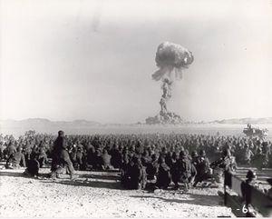
 November 1951 nuclear test at Nevada Test Site. Test is shot "Dog" from Operation Buster, with a yield of 21 kilotons. It was the first U.S. nuclear field exercise conducted on land; troops shown are a mere 6 miles from the blast. | |
| النوع | Nuclear testing range |
| الموقع | 37°07′N 116°03′W / 37.117°N 116.050°WCoordinates: 37°07′N 116°03′W / 37.117°N 116.050°W near Las Vegas in the United States |
| المساحة | ~1,350 mi² (~3,500 km²) |
| Operator | United States Department of Energy |
| Status | Active |
| In use | 1951–present |
| Testing | |
| Nuclear tests |
925+ |
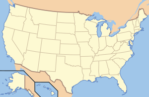
The location of the site. | |
A military test site infobox may be used to summarize information about a single military test site, such as a weapons range or nuclear test site. The infobox should be added using the {{Infobox Military Test Site}} template, as shown below:
{{Infobox Military Test Site
|name=
|image=
|caption=
|map=
|map_caption=
|type=
|coordinates=
|nearest_town=
|country=
|area=
|operator=
|status=
|dates=
|remediation=
|subcritical_tests=
|nuclear_tests=
|thermonuclear_tests=
|other_tests=
}}
Note: When using parameters, avoid the ambiguous abbreviation "N/A", and instead use "unknown" or "none". All subjective or qualitative judgements and numerical quantities or statistics must be cited to a reliable source (see WP:MILMOS#CITE).
- name – the formal name of the site.
- image – optional – an image of the site. The image must be given in the form [[Image:Example.jpg|300px]]; in particular, the thumb attribute must not be selected.
- caption – optional – the text to be placed below the image.
- map – optional – a map showing the location the site. The map may be given as a raw image; alternately, {{superimpose}} can be used in this field to generate a compound map.
- map_caption – optional – the text to be placed below the map.
- type – the type of site.
- coordinates – the location of the site, given as a coordinate pair by using {{coord}}.
- nearest_town – optional – in cases where the location is given as a coordinate pair, the town nearest to the memorial.
- country – optional – the country in which the site is located, if not obvious from the other location fields.
- area – optional – the total area of the site.
- operator – the country or other body responsible for operating the site.
- status – the current status of the site.
- dates – the period during which the site was in use; Use {{Start date}} for the first.
- remediation – optional – the remediation status of the site, if any.
- subcritical_tests – optional – for a nuclear test site, the number of subcritical tests conducted; if this is only a few tests, a full list may be given.
- nuclear_tests – optional – for a nuclear test site, the number of nuclear tests conducted; if this is only a few tests, a full list may be given.
- thermonuclear_tests – optional – for a nuclear test site, the number of thermonuclear tests conducted; if this is only a few tests, a full list may be given.
- other_tests – optional – any other tests conducted at the site. If this is only a few tests, a full list may be given; otherwise, an overall count or general description is preferred.
| The above documentation is transcluded from قالب:Infobox Military Test Site/doc. (edit | history) Editors can experiment in this template's sandbox (create | mirror) and testcases (create) pages. Please add categories to the /doc subpage. Subpages of this template. |
