جيولوجيا أفريقيا


جيولوجيا أفريقيا متنوعة ومعقدة، وتؤدي إلى مجموعة متنوعة من المناظر الطبيعية الخلابة في أرجاء القارة.
تقع القارة الأفريقية على صفيحتين رئيسيتين. الصفيحة الأفريقية، وهي تمثل شمال إفريقيا بالكامل، والصفيحة الصومالية، التي تمثل الجانب الشرقي من وسط وجنوب أفريقيا.[1] تتحرك الصفيحة الصومالية بعيداً عن الصفيحة الأفريقية في انفصام من جيبوتي في الشمال إلى إسواتيني في الجنوب.[2] شكـَّل انقسام هاتين الصفيحتين الجزء الجنوبي مما كان يُعرف باسم الوادي المتصدع الأكبر.[3] من الناحية الجيولوجية، شكّل فصل الصفيحتين الأفريقية والصومالية نظام صدع شرق أفريقيا (EARS)، الذي يتألف من نظامي فوالق منفصلين - الوادي المتصدع الشرقي، [4] وفرع غربي يعرف باسم الصدع الألبرتي.[5]
وقد تشكلت قبتان هائلتان، القبة الكينية والقبة الإثيوبية (تُعرف باسم المرتفعات الإثيوپية). الصدع الألبرتي يتبع الحافة الغربية للقبة الكينية. وهذا يجري من بحيرة ملاوي في الجنوب، ويتجه شمالاً إلى بحيرة روكوا وبحيرة تنگانيقا وبحيرة ألبرت في الشمال، حيث ينتهي. The Kenyan dome has the eastern branch of the EARS (known as The Gregory Rift) running through it's middle, and contains most of what we historically saw as the Great Rift valley. Lake Victoria lies in the middle of the dome, with the Gregory Rift to the east of it. The Gregory rift has Lake Eyasi & Lake Manyara at it's southern end, running north up to the west of Nairobi and continuing on through Kenya to Lake Turkana - which lies between the northern edge of the Kenyan dome and the southern edge of the Ethiopian dome.[6] The Ethiopian dome is split down the middle by the Eastern Rift, formed by the developing plate boundary, and has formed a valley running from Lake Chamo and Lake Abaya in the south, widening through Lake Shala, Lake Ziwa and Lake Koku, until it reaches it's widest point some 110 كم من جيبوتي.

الأحداث الجيولوجية الرئيسية
السمات الجيولوجية
جيولوجيو أفريقيا
خرائط جيولوجية
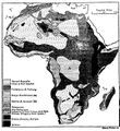
خريطة جيولوجية لأفريقيا في 1911
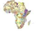
2015 surface lithology of Africa map


انظر أيضاً
للاستزادة
- Africa's Top Geological Sites (35th International Geological Congress Commemorative Volume), 2016 ISBN 9781775844488
المراجع
- ^ Schlüter, Thomas (2006). Geological Atlas of Africa (1st ed.). Springer-Verlag. pp. 26–29. ISBN 978-3-540-29144-2.
- ^ "Somali Plate". Ashten Sawitsky. Retrieved 30 June 2015.
- ^ Fernandes, R.M.S.; Ambrosius, B.A.C.; Noomen, R.; Bastos, L.; Combrinck, L.; Miranda, J.M.; Spakman, W. (2004). "Angular velocities of Nubia and Somalia from continuous GPS data: implications on present-day relative kinematics". Earth and Planetary Science Letters. 222 (1): 197–208. Bibcode:2004E&PSL.222..197F. doi:10.1016/j.epsl.2004.02.008.
- ^ Dawson 2008, p. 2.
- ^ Owiunji & Plumptre 2011, p. 164.
- ^ Schlüter, Thomas (2006). Geological Atlas of Africa (1st ed.). Springer-Verlag. p. 228. ISBN 978-3-540-29144-2.
وصلات خارجية
- United States Geological Survey maps of the geology of Africa (PDF)
- Interactive map of the topography of Africa - five selectable sources, including; OpenTopoMap, ESRI Topo & CyclOSM