إلبا
الاسم الأصلي: Isola d'Elba | |
|---|---|
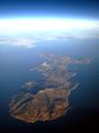
 Seen from the west, Monte Capanne in foreground | |
 | |
 | |
| الجغرافيا | |
| الموقع | البحر التيراني |
| الإحداثيات | - 42°46′58″N 10°17′11″E / 42.782711°N 10.286335°E |
| الأرخبيل | الأرخبيل التوسكاني |
| المساحة | 224 km2 (86 sq mi) |
| الخط الساحلي | 147 km (91٫3 mi) |
| أعلى منسوب | 1٬018 m (3٬340 ft) |
| الإدارة | |
ايطاليا | |
| السكان | |
| التعداد | 31,572 |
| الكثافة السكانية | 140 /km2 (360 /sq mi) |
جزيرة إلبا (بالإيطالية: Isola d'Elba أصد: [ˈiːzola ˈdelba] باللاتينية: Ilva) هي جزيرة إيطالية، تقع في البحر الأبيض المتوسط، وتتبع إدارياً لإقليم توسكانا وتحديداً لمقاطعة ليڤورنو. تبعد الجزيرة حوالي 20 كم من سواحل مدينة بيومبينو. عدد سكان الجزيرة حوالي 31,572 نسمة. والكثافة السكانية في إلبا حوالي 140/كم2. تبلغ مساحة الجزيرة 224 كم2 مما يجعلها أكبر جزيرة من جزر أرخبيل توسكان. وهي ثالث أكبر الجزر الإيطالية بعد كل من صقلية وسردينيا.[1] [2]
The island is part of the province of Livorno and is divided into seven municipalities, with a total population of about 30,000 inhabitants which increases considerably during the summer. The municipalities are Portoferraio (which is also the island's principal town), Campo nell'Elba, Capoliveri, Marciana, Marciana Marina, Porto Azzurro, and Rio.
Elba was the site of Napoleon's first exile, from 1814 to 1815.
الجغرافيا
Elba is the largest remaining stretch of land from the ancient tract that once connected the Italian peninsula to Corsica.[citation needed] The northern coast faces the Ligurian Sea, the eastern coast the Piombino Channel, the southern coast the Tyrrhenian Sea, and the Corsica Channel divides the western tip of the island from neighbouring Corsica.
جيولوجيا
The island itself is made up of slices of rocks which once formed part of the ancient Tethyan seafloor.[3] These rocks have been through at least two orogenies, the Alpine orogeny and the Apennine orogeny. The second of these two events was associated with subduction of the Tethyan oceanic crust underneath Italy and the obduction of parts of the ancient seafloor onto the continents. Later extension within the stretched inner part of the Apennine mountains caused adiabatic melting and the intrusion of the Mount Capanne and the La Serra-Porto Azzuro granitoids. These igneous bodies brought with them skarn fluids which dissolved and replaced some of the carbonate units, precipitating iron-rich minerals in their place. One of the iron-rich minerals, ilvaite, was first identified on the island and takes its name from the Latin word for Elba. More recently, high-angle faults formed within the tectonic pile, allowing for the migration of iron-rich fluids through the crust. The deposits left behind by these fluids formed the island's rich seams of iron ore.

The terrain is quite varied and is thus divided into several areas based on geomorphology. The mountainous and most recent part of the island can be found to the west, the centre of which is dominated by Mount Capanne (at a height of 1,018 metres, or 3,340 feet), also called the "roof of the Tuscan Archipelago". The mountain is home to many animal species including the mouflon and wild boar, two species that flourish despite the continuous influx of tourists. The central part of the island is a mostly flat section with the width being reduced to just four kilometres (2.5 mi). It is where the major centres can be found: Portoferraio, Campo nell'Elba. To the east is the oldest part of the island, formed over 3 million years ago.[4] In the hilly area, dominated by Monte Calamita, are the deposits of iron that made Elba famous.
الهيدروگرافيا
Rivers rarely exceed 3 km (2 mi) in length, and it is common for the shorter ones to dry up during the summer. The largest rivers, sorted by length, are:
- Fosso San Francesco 6.5 km (4.0 mi);
- Fosso Barion, 5.1 km (3.2 mi);
- Fosso Redinoce, 2 km (1.2 mi)
المناخ
يعتبر مناخ إلبا مناخاً متوسطياً، باستثناء جبل كاپانّي (بالإيطالية: Mount Capanne)، حيث يكون الشتاء بارداً معتدلاً. ويتركز هطول الأمطار في الخريف ويضم أمطاراً عادية.
ويبين الجدول أدناه متوسط درجات الحرارة لإلبا حسب كل شهر:
| بيانات المناخ لـ إلبا | |||||||||||||
|---|---|---|---|---|---|---|---|---|---|---|---|---|---|
| الشهر | ينا | فب | مار | أبر | ماي | يون | يول | أغس | سبت | أكت | نوف | ديس | السنة |
| القصوى القياسية °س (°ف) | 16.2 (61.2) |
18.0 (64.4) |
20.0 (68.0) |
22.4 (72.3) |
29.6 (85.3) |
32.0 (89.6) |
34.3 (93.7) |
36.1 (97.0) |
32.0 (89.6) |
25.0 (77.0) |
24.6 (76.3) |
16.8 (62.2) |
36.1 (97.0) |
| متوسط القصوى اليومية °س (°ف) | 9.6 (49.3) |
10.0 (50.0) |
12.0 (53.6) |
14.2 (57.6) |
18.8 (65.8) |
22.7 (72.9) |
26.5 (79.7) |
26.7 (80.1) |
22.6 (72.7) |
18.0 (64.4) |
13.4 (56.1) |
10.5 (50.9) |
17.1 (62.8) |
| المتوسط اليومي °س (°ف) | 7.4 (45.3) |
7.5 (45.5) |
9.2 (48.6) |
11.4 (52.5) |
15.6 (60.1) |
19.3 (66.7) |
22.7 (72.9) |
23.1 (73.6) |
19.5 (67.1) |
15.4 (59.7) |
11.2 (52.2) |
8.5 (47.3) |
14.2 (57.6) |
| متوسط الدنيا اليومية °س (°ف) | 5.3 (41.5) |
5.0 (41.0) |
6.3 (43.3) |
8.5 (47.3) |
12.3 (54.1) |
15.8 (60.4) |
19.0 (66.2) |
19.5 (67.1) |
16.4 (61.5) |
12.9 (55.2) |
9.0 (48.2) |
6.5 (43.7) |
11.4 (52.5) |
| الصغرى القياسية °س (°ف) | −7.4 (18.7) |
−4.4 (24.1) |
−5.4 (22.3) |
1.2 (34.2) |
3.4 (38.1) |
5.0 (41.0) |
12.2 (54.0) |
11.6 (52.9) |
7.6 (45.7) |
2.0 (35.6) |
−1.0 (30.2) |
−5.4 (22.3) |
−7.4 (18.7) |
| متوسط تساقط الأمطار mm (inches) | 59.5 (2.34) |
75.6 (2.98) |
56.2 (2.21) |
57.8 (2.28) |
31.6 (1.24) |
26.8 (1.06) |
13.8 (0.54) |
41.5 (1.63) |
75.0 (2.95) |
101.6 (4.00) |
88.7 (3.49) |
50.5 (1.99) |
678.6 (26.71) |
| Average precipitation days (≥ 1.0 mm) | 6.7 | 6.2 | 6.9 | 7.0 | 5.0 | 3.5 | 1.6 | 2.4 | 5.0 | 7.9 | 7.3 | 5.8 | 65.3 |
| متوسط الرطوبة النسبية (%) | 77 | 76 | 75 | 76 | 76 | 73 | 68 | 72 | 76 | 80 | 81 | 79 | 76 |
| Mean monthly ساعات سطوع الشمس | 133.3 | 118.7 | 155.0 | 183.0 | 195.3 | 237.0 | 275.9 | 257.3 | 201.0 | 151.9 | 117.0 | 114.7 | 2٬140٫1 |
| Source 1: Servizio Meteorologico (temperature and precipitation data 1971-2000)[5] | |||||||||||||
| Source 2: Servizio Meteorologico (relative humidity and sun data 1961-1990)[6] | |||||||||||||
التقسيم الإداري
تقسم جزيرة إلبا إلى 8 بلديات:
پورتوفيرايو

پورتوفيرايو (بالإيطالية: Portoferraio)، هي مركز الجزيرة والبلدية الرئيسية فيها. تبلغ مساحتها حوالي 47.46 كم2. يبلغ عدد سكانها حوالي 12,136 نسمة. بسبب تضاريسها تقع مباني المدينة في منحدرات تل صغير محاط بالبحر من ثلاثة جهات.
أسس هذه المدينة كوزيمو الأول ده مديتشي، دوق توسكانيا الأعظم (Cosimo I de' Medici)، عام 1548 باسم كوسمبولي (Cosmopoli)، الذي يعني مدينة كوزيمو .
كامپو نيل إلبا
- كامپو نيل إلبا (Campo nell'Elba):
- كاپلڤيري (Capoliveri):
- ماركيانا (Marciana):
- ماركيانا مارينا (Marciana Marina):
- پورتو آزورو (Porto Azzurro):
- ريو مارينا (Rio Marina):
- ريو نيل إلبا (Rio nell'Elba):
تاريخ


النقل

الهوامش
- ^ "إلبا". ويكيبيديا.
- ^ الموسوعة البريطانية - Britannica Online Encyclopedia (إلبا - Elba)
- ^ "The association of continental crust rocks with ophiolites in the Northern Apennines (Italy): implications for the continent-ocean transition in the Western Tethys" (PDF). els-cdn.com.
- ^ Bortolotti, Valerio; Fazzuoli, Milvio; Pandeli, Enrico; Principi, Gianfranco; Babbini, Amedeo; Corti, Simone (2001). "Login". Ofioliti. 26 (2a): 97–150.
- ^ "ELBA/M. CALAMITA" (PDF). Servizio Meteorologico. Retrieved 13 October 2012.
- ^ Elba -Monte Calamita "MONTE CALAMITA - ELBA". Servizio Meteorologico. Retrieved 13 October 2012.
{{cite web}}: Check|url=value (help)
المصادر
- Chandler, David G. (1990). The Illustrated Napoleon. New York: Henry Holt & Co. ISBN 0-8050-0442-4.
معرض الصور
-
-
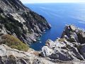 West coast of Elba
 -
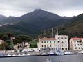 Marciana Marina
 -
 Capoliveri
 -
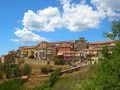 Capoliveri
 -
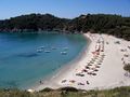 Fetovaia beach


وصلات خارجية
- إلبا at the Open Directory Project
- Pages using gadget WikiMiniAtlas
- CS1 errors: URL
- Short description is different from Wikidata
- Articles with hatnote templates targeting a nonexistent page
- Missing redirects
- Coordinates on Wikidata
- Pages using infobox islands with unknown parameters
- Articles with unsourced statements from June 2023
- إلبا
- جزر توسكانا
- جزر البحر المتوسط
- Arcipelago Toscano National Park
- قصور ومساكن ناپليون
- توسكانا
- مناطق النبيذ في ايطاليا