أرتوا
أرتوا Artois (النطق الفرنسي: [aʁˈtwa]؛ الصفة أرتوي؛ هولندية: Artesië)، هي مقاطعة سابقة في شمال فرنسا. تبلغ مساحة أراضيها حوالي 4.000 كم² وعدد سكانها حوالي مليون نسمة. مدنها الرئيسية هي أرا، (بالهولندية: Atrecht)، سان-اومير، لـِن وبيتون.
| Government of Artois Gouvernment d'Artois | |||||||||
|---|---|---|---|---|---|---|---|---|---|
| 1764–1790 | |||||||||
 Flag | |||||||||
 موقع أرتوا في فرنسا (حدود 1789) | |||||||||
| العاصمة | Arras | ||||||||
| صفة المواطن | Artesians (فرنسية: Artésiens) | ||||||||
| التاريخ | |||||||||
| الحكومة | |||||||||
| • النوع | مقاطعة | ||||||||
| ملك فرنسا | |||||||||
• 1764–1774 | لويس الخامس عشر | ||||||||
• 1774–1790 | Louis XVI | ||||||||
| Governor of Artois | |||||||||
• 1764–1787 | François Gaston de Lévis | ||||||||
• 1788–1789 | Adrien-Louis de Bonnières | ||||||||
| العصر التاريخي | Early Modern | ||||||||
• County created | 1764 | ||||||||
• Disestablished | 1790 | ||||||||
| |||||||||
| اليوم جزء من | فرنسا | ||||||||
. . . . . . . . . . . . . . . . . . . . . . . . . . . . . . . . . . . . . . . . . . . . . . . . . . . . . . . . . . . . . . . . . . . . . . . . . . . . . . . . . . . . . . . . . . . . . . . . . . . . . . . . . . . . . . . . . . . . . . . . . . . . . . . . . . . . . . . . . . . . . . . . . . . . . . . . . . . . . . . . . . . . . . . .
الموقع
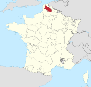
أرتوا (بالقرمزي) داخل منطقة أراضي كاليه الشمالية. |
تقع أرتوا داخل منطقة أراضي كاليه الشمالية،[1] المنطقة الشرقية تشكل بولونيا. تمتد أرتوا بين نقاط أرا، بيتون، سان-اومير ولـِن، والمنطقة الشرقية من نقاط مونتريول. تشغل الطرف الغربي لحقل الفحم الذي يمتد شرقاً عبر اقليم نور وعبر وسط بلجيكا.
الجيولوجيا
Southern Artois is marked by the Artois hills, which correspond to an uplift zone along numerous parallel fault lines.
The dip of the clay layers and the porous layers explains the phenomenon known as artesian wells.
التاريخ
Originally a feudal county itself, Artois was annexed by the county of Flanders. It came to France in 1180 as a dowry of a Flemish princess, Isabelle of Hainaut, and was again made a separate county in 1237 for Robert, a grandson of Isabelle. Through inheritance, Artois came under the rule of the dukes of Burgundy in 1384. At the death of the fourth duke, Charles the Bold, Artois was inherited by the Habsburgs and passed to the dynasty's Spanish line. After the religious revolts of 1566 in the Netherlands, Artois briefly entered the Dutch Revolt in 1576, participating in the Pacification of Ghent until it formed the Union of Atrecht in 1579.
After the Union of Atrecht, Artois and Hainaut (Dutch: Henegouwen) reached a separate agreement with Philip II. Artois remained with the Spanish Netherlands until it was conquered by France during the Franco-Spanish War. The annexation was acknowledged during the Treaty of the Pyrenees in 1659, and it became a French province. Artois had already been largely French-speaking, but it was part of the Southern Netherlands until the French annexation.
Artois experienced rapid industrial development during the second half of the 19th century, fueled by its rich coal resources. During World War I, the front line between the opposing Central Powers and Allied armies in France ran through the province, resulting in enormous physical damage. Since the second half of the 20th century, Artois has suffered along with nearby areas because of the decline of the coal industry.
مشاهير السكان
- Pierre-Charles Le Sueur، (ح.1657-ح.1705)، وُلد في أرتوا، مستكشف وتاجر شهير.[2]
- ماكسميليان روبسپيير (1758–1794)، زعيم ثوري فرنسي، وُلد في أرتوا.
- Carolus Clusius
انظر أيضاً
- Communauté d'agglomération de l'Artois
- معركة أرتوا (توضيح)
- مقاطعة أرتوا
- كونتات أرتوا
- كونتيسة أرتوا
- Weald-Artois Anticline، حافة جبلية كانت تصل قارة اوروپا وبريطانيا حتى 220.000 سنة مضت.
المصادر
- ^ "Artois" in The New Encyclopaedia Britannica. Chicago: Encyclopaedia Britannica Inc., 15th edn., 1992, Vol. 1, p. 607.
- ^ Who Was Who in America, Historical Volume, 1607–1896. Chicago: Marquis Who's Who. 1963.