أعمال زويدرزي

أعمال زويدرزي (هولندية: Zuiderzeewerken) are a man-made system of dams and dikes, land reclamation and water drainage works, in total the largest hydraulic engineering project undertaken by the Netherlands during the twentieth century. The project involved the damming of the Zuiderzee, a large, shallow inlet of the North Sea, and the reclamation of land in the newly enclosed water using polders. Its main purposes are to improve flood protection and create additional land for agriculture.
The American Society of Civil Engineers declared these works, together with the Delta Works in the South-West of the Netherlands, as among the Seven Wonders of the Modern World.

خلفية


في 14 يونيو 1918 تم تمرير قانون زويدرزي.[1] كان للقانون ثلاثة أهداف:
- حماية وسط هولندا من آثار بحر الشمال؛
- زيادة إمدادات الغذاء الهولندية بتطوير واستزراع أرض زراعية جديدة؛
- تحسين ادارة المياه بخلق بحيرة مياه عذبة من بوغاز المياه المالحة الذي لم يكن محكوماً من قبل.
مرحلة الإنشاء
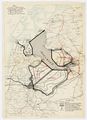
المنطقة المطوّقة

| المشروع | السد | الطول | بدأ | المساحة المطوقة | الحجم | يصرِف |
| ربط جزيرة ڤيرنگن بهولندا القارية | Amsteldiepdijk | 2.5 كم | 29 يونيو 1920 | 31 يوليو 1924 | — | — |
| طوق زويدرزي | Afsluitdijk | 32 كم | يناير 1927 | 23 مايو 1932 | — | — |
| Pilot Polder Andijk | - | 1.9 كم | 1926 | مطلع 1927 | 40 هكتار | 27 أغسطس 1927 |
| ڤيرنگرمير Polder | - | 18 كم | 1927 | 27 يوليو 1929 | 20,000 ha | 31 أغسطس 1930 |
| Noordoostpolder | - | 55 كم | 1936 | 13 ديسمبر 1940 | 48,000 هكتار | 9 سبتمبر 1942 |
| Eastern Flevoland Polder | - | 90 كم | مطلع 1950 | 13 سبتمبر 1956 | 54,000 هكتار | 29 يونيو 1957 |
| Southern Flevoland Polder | - | 70 كم | مطلع 1959 | October 25, 1967 | 43,000 هكتار | 29 مايو 1968 |
| Markerwaard Polder | Houtribdijk | 28 كم | 1963 | 4 سبتمبر 1975 | (41,000 هكتار) | لم يتم |
استصلاح الأراضي

Polders
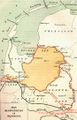
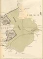
ڤيرنگرمير

.png&filetimestamp=20190220040754&)
The North Sea flood of 1953 made the government change its priorities. Instead of granting the new land only to farmers selected for their skill, the government granted land to a large number of farmers from the flooded province of Zeeland.
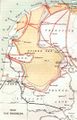
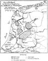
فلڤولاند
فلڤولاند الشرقية
| Polder | الحكم | الزراعة | الإسكان | الطبيعة | البنية التحتية |
| ڤيرنگرمير | 200 كم² | 87% | 1% | 3% | 9% |
| Noordoostpolder | 480 كم² | 87% | 1%[citation needed] | 5% | 7% |
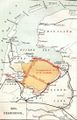
| Eastern Flevoland | 540 كم² | 75% | 8% | 11% | 6% |
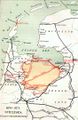
| Southern Flevoland | 430 km² | 50% | 25% | 18% | 7% |
.png&filetimestamp=20190220040742&)
فلڤولاند الجنوبية
مقاطعة فلڤولاند
-
 Plan Kloppenburg en Faggedon
(1848) -
 Plan Van Diggelen
(1849) -
 Plan Beyerinck
(1866) -
 Plan Stieltjes
(1870-1873) -
 Plan Lely
(?) -
 Plan Lely
(1891) -
 Plan Zuiderzeewerken
(1907)


انظر أيضاً
- أعمال الدلتا وهو مشروع آخر للأعمال المائية في هولندا.
- Lauwerszee Works
- التحكم في الفيضانات في هولندا
- فيضان
- Zuiderzeemuseum
الهامش
- ^ "TZuiderzeewet". Nieuwlanderfgoed. Retrieved 2009-01-17.
وصلات خارجية
- Nieuw Land Poldermuseum – A Flevoland museum on the Zuiderzee Works and Dutch water management in general.
- The Zuiderzee Museum – Dedicated to the history and culture of the former Zuiderzee.
- Directorate IJsselmeer Region – The administration responsible for maintaining most of the Zuiderzee Works.
- Zuiderzee Cycle Route, long-distance cycle route around the former Zuiderzee.
- Articles containing هولندية-language text
- Pages using Lang-xx templates
- Articles with unsourced statements from August 2015
- Netherlands articles missing geocoordinate data
- All articles needing coordinates
- القرن العشرون في هولندا
- تاريخ العلوم والتكنولوجيا في هولندا
- Causeways in Europe
- Historic Civil Engineering Landmarks
- سدود هولندا
- Dikes in the Netherlands
- Flood control in the Netherlands
- Zuiderzee Works
- Dams completed in 1924
- Polders of North Holland
- Polders of the Netherlands
- Polders of Flevoland
- Landforms of Friesland