دورة المياه العميقة
| جزء من سلسلة عن |
| الدورات الكيميائية الأرضية الحيوية |
|---|
 |
دورة المياه العميقة أو دورة المياه الجيولوجية (deep water cycle، geologic water cycle)، تتضمن تبادل المياه مع الوشاح، مع نقل المياه إلى أسفل بواسطة اندساس الصفائح المحيطية والعودة من خلال النشاط البركاني، التي تختلف عن دورة الماء التي تحدث في الأعلى وعلى سطح الأرض.[1]
يصل بعض الماء إلى الوشاح السفلي وقد يصل حتى اللب الخارجي. تُظهر تجارب فيزياء المعادن أن المعادن المائية يمكن أن تحمل الماء إلى عمق الوشاح في ألواح أكثر برودة، وحتى "المعادن اللامائية اسميًا" يمكن أن تخزن ما يكفي من المياه في العديد من المحيطات.
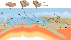
تتضمن عملية إعادة تدوير المياه العميقة دخول الماء إلى الوشاح عن طريق نقله إلى أسفل بواسطة صفائح محيطية مغمورة (وهي عملية تُعرف باسم إعادة تجميع الغازات) التي يتم موازنتها بواسطة المياه التي يتم إطلاقها في مرتفعات وسط المحيط (التفريغ).[1] يعتبر هذا مفهوماً مركزياً في فهم التبادل طويل الأمد للمياه بين باطن الأرض والإكسوسفير ونقل المياه المرتبطة بالمعادن المائية.[2]
مقدمة
In the conventional view of the water cycle (also known as the hydrologic cycle), water moves between reservoirs in the atmosphere and Earth's surface or near-surface (including the ocean, rivers and lakes, glaciers and polar ice caps, the biosphere and groundwater). However, in addition to the surface cycle, water also plays an important role in geological processes reaching down into the crust and mantle. Water content in magma determines how explosive a volcanic eruption is; hot water is the main conduit for economically important minerals to concentrate in hydrothermal mineral deposits; and water plays an important role in the formation and migration of petroleum.[3]
Water is not just present as a separate phase in the ground. Seawater percolates into oceanic crust and hydrates igneous rocks such as olivine and pyroxene, transforming them into hydrous minerals such as serpentines, talc and brucite.[4] In this form, water is carried down into the mantle. In the upper mantle, heat and pressure dehydrates these minerals, releasing much of it to the overlying mantle wedge, triggering the melting of rock that rises to form volcanic arcs.[5] However, some of the "nominally anhydrous minerals" that are stable deeper in the mantle can store small concentrations of water in the form of hydroxyl (OH−),[6] and because they occupy large volumes of the Earth, they are capable of storing at least as much as the world's oceans.[3]
The conventional view of the ocean's origin is that it was filled by outgassing from the mantle in the early Archean and the mantle has remained dehydrated ever since.[7] However, subduction carries water down at a rate that would empty the ocean in 1–2 billion years. Despite this, changes in the global sea level over the past 3–4 billion years have only been a few hundred metres, much smaller than the average ocean depth of 4 kilometres. Thus, the fluxes of water into and out of the mantle are expected to be roughly balanced, and the water content of the mantle steady. Water carried into the mantle eventually returns to the surface in eruptions at mid-ocean ridges and hotspots.[8] This circulation of water into the mantle and back is known as the deep water cycle or the geologic water cycle.[9][10][11][5]
Estimates of the amount of water in the mantle range from 1⁄4 to 4 times the water in the ocean.[12] There are 1.37×10¹⁸ m3 of water in the seas, therefore, this would suggest that there is between 3.4×10¹⁷ and 5.5×10¹⁸ m3 of water in the mantle. Constraints on water in the mantle come from mantle mineralogy, samples of rock from the mantle, and geophysical probes.
قدرة التخزين
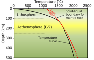
An upper bound on the amount of water in the mantle can be obtained by considering the amount of water that can be carried by its minerals (their storage capacity). This depends on temperature and pressure. There is a steep temperature gradient in the lithosphere where heat travels by conduction, but in the mantle the rock is stirred by convection and the temperature increases more slowly (see figure).[13] Descending slabs have colder than average temperatures.

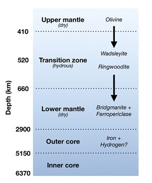
The mantle can be divided into the upper mantle (above 410 km depth), transition zone (between 410 km and 660 km), and the lower mantle (below 660 km). Much of the mantle consists of olivine and its high-pressure polymorphs. At the top of the transition zone, it undergoes a phase transition to wadsleyite, and at about 520 km depth, wadsleyite transforms into ringwoodite, which has the spinel structure. At the top of the lower mantle, ringwoodite decomposes into bridgmanite and ferropericlase.[14]
The most common mineral in the upper mantle is olivine. For a depth of 410 km, an early estimate of 0.13 percentage of water by weight (wt%) was revised upwards to 0.4 wt% and then to 1 wt%.[12][15] However, the carrying capacity decreases dramatically towards the top of the mantle. Another common mineral, pyroxene, also has an estimated capacity of 1 wt% near 410 km.[12]
In the transition zone, water is carried by wadsleyite and ringwoodite; in the relatively cold conditions of a descending slab, they can carry up to 3 wt%, while in the warmer temperatures of the surrounding mantle their storage capacity is about 0.5 wt%.[16] The transition zone is also composed of at least 40% majorite, a high pressure phase of garnet;[17] this only has capacity of 0.1 wt% or less.[18]
The storage capacity of the lower mantle is a subject of controversy, with estimates ranging from the equivalent of 3 times to less than 3% of the ocean. Experiments have been limited to pressures found in the top 100 km of the mantle and are challenging to perform. Results may be biased upwards by hydrous mineral inclusions and downwards by a failure to maintain fluid saturation.[19]
At high pressures, water can interact with pure iron to get FeH and FeO. Models of the outer core predict that it could hold as much as 100 oceans of water in this form, and this reaction may have dried out the lower mantle in the early history of Earth.[20]
المياه من الوشاح
قدرة تحمل الوشاح ليست سوى حد أعلى، ولا يوجد سبب مقنع لافتراض أن الوشاح مشبع.[21] تأتي القيود الإضافية على كمية وتوزيع المياه في الوشاح من التحليل الجيوكيميائي للبازلت المنفجر والزينوليث من الوشاح.
البازلت
يتشكل البازلت حيود وسط المحيط وينشأ النقاط الساخنة في الوشاح ويستخدم لتوفير معلومات عن تكوين الوشاح. قد تخضع الصهارة المتصاعدة إلى السطح للتبلور التجزيئي حيث تستقر المكونات ذات نقاط الانصهار الأعلى أولاً، ويمكن أن تحتوي الانصهار الناتج على محتويات مائية متنوعة على نطاق واسع؛ لكن عندما يحدث فصل صغير، يكون محتوى الماء حوالي 0.07–0.6% وزناً. (بالمقارنة، البازلت في أحواض القوس الخلفي حول الأقواس البركانية يتراوح وزنها بين 1% و 2.9% وزناً بسبب المياه المنبعثة من صفيحة الاندساس.)[20]
تُصنف البازلت حيد وسط المحيط (MORBs) بشكل شائع من خلال وفرة العناصر الزرة التي تعتبر غير متوافقة مع المعادن التي تستقر فيها. وهي مقسمة إلى MORB "عادية" أو N-MORB، مع وفرة منخفضة نسبيًا من هذه العناصر، وE-MORB المخصبة.[22] يرتبط إثراء الماء جيدًا بإثراء هذه العناصر. في N-MORB، يُستنتج أن المحتوى المائي لغطاء المصدر هو 0.08–0.18 wt%، بينما في E-MORB يكون 0.2–0.95 wt%.[20]
هناك تصنيف شائع آخر، بناءً على تحليلات MORBs وبازلت جزر المحيطات (OIBs) من النقاط الساخنة، يحدد خمسة مكونات. يعتبر بازلت المنطقة البؤرية (FOZO) الأقرب إلى التكوين الأصلي للوشاح. يُعتقد أن عضوين نهائيين مخصبين (EM-1 و EM-2) ينشآن من إعادة تدوير رواسب المحيطات و OIBs. HIMU تعني "high-μ"، حيث μ هي نسبة اليورانيوم ونظائر الرصاص (μ = 238U/204Pb). المكون الخامس يكون مستنفد MORB (DMM).[23] نظرًا لأن سلوك الماء مشابه جدًا لسلوك العنصر السيزيوم، غالبًا ما تستخدم نسب الماء إلى السيزيوم لتقدير تركيز الماء في المناطق التي تعتبر مصادر للمكونات.[12] حددت دراسات متعددة محتوى الماء في FOZO بحوالي 0.075% وزناً، ومن المحتمل أن يكون الكثير من هذه المياه مياه "صغرى" تم الحصول عليها أثناء تراكم الأرض. يحتوي DMM على 60 جزء في المليون من الماء.[9] إذا أخذت هذه المصادر عينات من جميع مناطق الوشاح، فإن إجمالي المياه يعتمد على نسبتها؛ بما في ذلك حالات عدم اليقين، تتراوح التقديرات من 0.2 إلى 2.3 محيط.[12]
شوائب الماس

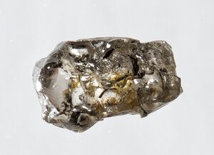
وُجد في الماس عينات معدنية من المنطقة الانتقالية والوشاح السفلي تأتي من مكتنفات. اكتشف الباحثون مؤخرًا شوائب الماس من الجليد السابع في المنطقة الانتقالية. الجليد السابع هو ماء في حالة ضغط مرتفع. يشير وجود الماس الذي تشكل في المنطقة الانتقالية ويحتوي على شوائب من الجليد السابع إلى وجود الماء في المنطقة الانتقالية وفي الجزء العلوي من الوشاح السفلي. من بين ثلاث عشرة حالة جليد سابع عُثر عليها، ثمانية منها لديها ضغوط حوالي 8-12 جيجا باسكال، مما يؤدي إلى تتبع تكوين الشوائب إلى 400-550 كم. يحتوي اثنان من الإضافات على ضغوط تتراوح بين 24 و25 جيجا پاسكال، مما يشير إلى تكوين شوائب عند 610-800 كم.[25] توفر ضغوط شوائب الجليد السابع دليلًا على أن الماء يجب أن يكون موجودًا في الوقت الذي تشكل فيه الماس في المنطقة الانتقالية من أجل أن يصبح محاصرًا على شكل شوائب. يقترح الباحثون أيضًا أن نطاق الضغوط التي تشكلت عندها الشوائب تشير إلى وجود شوائب كسوائل بدلاً من مواد صلبة.[25][24]
عُر على ماسة أخرى تحمل شوائب رينگووديت. باستخدام تقنيات تشمل التحليل الطيفي بالأشعة تحت الحمراء ومطياف رامان وحيود الأشعة السينية، وجد العلماء أن محتوى الماء في الرينگوودايت كان 1.4% وزناً واستنتجوا أن المحتوى المائي الأكبر من الوشاح يقارب 1% وزناً.[26]
الدليل الجيوفيزيائي
النشاط الزلزالي
يشير كل من الانخفاض المفاجئ في النشاط الزلزالي والتوصيل الكهربائي إلى أن المنطقة الانتقالية قادرة على إنتاج الرينگووديت المائي. إن تجربة USArray الزلزالية هي مشروع طويل المدى باستخدام مقياس الزلازل لرسم خريطة الوشاح الأساسي للولايات المتحدة. باستخدام بيانات من هذا المشروع، تُظهر قياسات مقياس الزلازل أدلة مقابلة على الذوبان في الجزء السفلي من المنطقة الانتقالية.[27] يمكن تصور الذوبان في المنطقة الانتقالية من خلال قياسات السرعة الزلزالية حيث تنخفض السرعة الحادة في الوشاح السفلي بسبب اندفاع الألواح عبر المنطقة الانتقالية. يرتبط الانخفاض المقاس في السرعات الزلزالية بدقة مع الوجود المتوقع للذوبان لوزن 1 % ذوبان H2O.[28]
اكتشفت منطقة السرعة المنخفضة للغاية (ULVZs) فوق حدود الوشاح الأساسي (CMB). تتوافق تجارب تسلط الضوء على وجود پيروكسيد الحديد المحتوي على الهيدروجين (FeO2Hx) مع توقعات ULVZs. يعتقد الباحثون أن الحديد والماء يمكن أن يتفاعلا لتشكيلFeO2Hx في مناطق السرعة المنخفضة للغاية ULVZs عند حدود الوشاح الأساسي. سيكون هذا التفاعل ممكنًا مع تفاعل اندساس المعادن المحتوية على الماء والإمداد الواسع بالحديد في اللب الخارجي للأرض. اقترحت الأبحاث السابقة وجود ذوبان جزئي في مناطق السرعة المنخفضة للغاية، لكن تكوين الذوبان في المنطقة المحيطة.[29]
الاندساس
عندما تهبط صفيحة محيطية إلى الوشاح العلوي، تميل معادنها إلى فقد الماء. كمية المياه المفقودة وتوقيتها يعتمد على الضغط ودرجة الحرارة وعلم المعادن. يحمل الماء مجموعة متنوعة من المعادن التي تجمع بين نسب مختلفة من أكسيد المغنيسيوم (MgO)، ثاني أكسيد السليكون (SiO2)، والماء.[30] تحت الضغوط المنخفضة (أقل من 5 ج.ب.) ، تشمل هذه الأنتيگوريت، وهو شكل من أشكال السربنتين، والكلينوكلور (كلاهما يحمل 13 wt%)؛ التلك (4.8 wt%) وبعض المعادن الأخرى ذات السعة المنخفضة. تحت ضغط معتدل (5-7 ج.ب.) تشمل المعادن الفلوگوپيت (4.8 wt%)، مرحلة 10Å (منتج عالي الضغط من التلك والماء،[31] 10–13 wt%) واللاوسونيت (11.5 wt%). عند الضغوط الأعلى من 7 ج.ب.، يوجد topaz-OH (Al2SiO4(OH)2، 10 wt%)، مرحلة البيضة (AlSiO3(OH), 11–18 wt%) ومجموعة من سيليكات المغنيسيوم المائية الكثيفة (DHMS) أو المرحلة "الأبجدية" مثل المرحلة A (12 wt%)، D (10 wt%) والمرحلةE (11 wt%).[32][30]
يعتمد مصير الماء على ما إذا كانت هذه المراحل يمكن أن تحافظ على سلسلة غير منقطعة أثناء هبوط اللوح. على عمق حوالي 180 كم، حيث يكون الضغط حوالي 6 جيجا باسكال (GPa) ودرجة الحرارة حوالي 600 درجة مئوية، هناك "نقطة انخناق" محتملة حيث مناطق الاستقرار فقط يقابل. ستفقد الألواح الأكثر سخونة كل مياهها بينما تمرر الألواح الباردة الماء إلى مراحل DHMS.[16] في الألواح الأكثر برودة، قد يكون بعض الماء المنطلق مستقرًا مثل الجليد السابع.[33][34]
أقترح عدم توازن في إعادة تدوير المياه العميقة كإحدى الآليات التي يمكن أن تؤثر على مستويات البحار العالمية.[1]
انظر أيضاً
المصادر
- ^ أ ب ت Rüpke, Lars; Phipps Morgan, Jason; Eaby Dixon, Jacqueline (2013-03-19), Jacobsen, Steven D.; Van Der Lee, Suzan, eds., Implications of Subduction Rehydration for Earth's Deep Water Cycle, Washington, D. C.: American Geophysical Union, pp. 263–276, doi:, ISBN 978-1-118-66648-7, https://onlinelibrary.wiley.com/doi/10.1029/168GM20, retrieved on 2021-10-21
- ^ Magni, Valentina; Bouilhol, Pierre; Hunen, Jeroen van (2014). "Deep water recycling through time". Geochemistry, Geophysics, Geosystems (in الإنجليزية). 15 (11): 4203–4216. Bibcode:2014GGG....15.4203M. doi:10.1002/2014GC005525. ISSN 1525-2027. PMC 4548132. PMID 26321881.
- ^ أ ب Bodnar, R.J.; Azbej, T.; Becker, S.P.; Cannatelli, C.; Fall, A.; Severs, M.J. (2013). "Whole Earth geohydrologic cycle, from the clouds to the core: The distribution of water in the dynamic Earth system" (PDF). In M.E., Bickford (ed.). The Web of Geological Sciences: Advances, Impacts, and Interactions: Geological Society of America Special Paper 500. The Geological Society of America. pp. 431–461. doi:10.1130/2013.2500(13). ISBN 9780813725000. Retrieved 19 April 2019.
- ^ Peacock, Simon M.; Hyndman, Roy D. (15 August 1999). "Hydrous minerals in the mantle wedge and the maximum depth of subduction thrust earthquakes". Geophysical Research Letters. 26 (16): 2517–2520. Bibcode:1999GeoRL..26.2517P. doi:10.1029/1999GL900558.
- ^ أ ب Rüpke, L; Morgan, Jason Phipps; Hort, Matthias; Connolly, James A. D. (June 2004). "Serpentine and the subduction zone water cycle". Earth and Planetary Science Letters. 223 (1–2): 17–34. Bibcode:2004E&PSL.223...17R. doi:10.1016/j.epsl.2004.04.018.
- ^ Bell, D. R.; Rossman, G. R. (13 March 1992). "Water in Earth's Mantle: The Role of Nominally Anhydrous Minerals". Science. 255 (5050): 1391–1397. Bibcode:1992Sci...255.1391B. doi:10.1126/science.255.5050.1391. PMID 17801227. S2CID 26482929. Retrieved 23 April 2019.
- ^ Keppler, Hans (2013). "Volatiles under high pressure". In Karato, Shun-ichiro; Karato, Shun'ichirō (eds.). Physics and chemistry of the deep Earth. John Wiley & Sons. pp. 22–23. doi:10.1002/9781118529492.ch1. ISBN 9780470659144.
- ^ Hirschmann 2006, p. 646
- ^ أ ب Rüpke, Lars; Morgan, Jason Phipps; Dixon, Jacqueline Eaby (2013). "Implications of Subduction Rehydration for Earth's Deep Water Cycle" (PDF). Earth's Deep Water Cycle (PDF). Geophysical Monograph Series. pp. 263–276. doi:10.1029/168GM20. ISBN 9781118666487. Retrieved 20 April 2019. In Jacobsen & Van Der Lee 2006.
- ^ Magni, Valentina; Bouilhol, Pierre; van Hunen, Jeroen (November 2014). "Deep water recycling through time". Geochemistry, Geophysics, Geosystems. 15 (11): 4203–4216. Bibcode:2014GGG....15.4203M. doi:10.1002/2014GC005525. PMC 4548132. PMID 26321881.
- ^ Korenaga, J. (10 December 2011). "Thermal evolution with a hydrating mantle and the initiation of plate tectonics in the early Earth". Journal of Geophysical Research. 116 (B12). Bibcode:2011JGRB..11612403K. doi:10.1029/2011JB008410. S2CID 40490409.
- ^ أ ب ت ث ج Hirschmann 2006, pp. 630–634
- ^ Turcotte, Donald L.; Schubert, Gerald (2002). "4-28 Mantle geotherms and adiabats". Geodynamics (2nd ed.). Cambridge University Press. pp. 185–188. ISBN 978-0-521-66624-4.
- ^ Christensen, U.R. (1995). "Effects of phase transitions on mantle convection". Annu. Rev. Earth Planet. Sci. 23: 65–87. Bibcode:1995AREPS..23...65C. doi:10.1146/annurev.ea.23.050195.000433.
- ^ Smyth, Joseph R.; Jacobsen, Steven D. (2013). "Nominally anhydrous minerals and Earth's deep water cycle". Earth's Deep Water Cycle. Geophysical Monograph Series. pp. 1–11. doi:10.1029/168GM02. ISBN 9781118666487. S2CID 8066681. In Jacobsen & Van Der Lee 2006.
- ^ أ ب Ohtani, Eiji; Litasov, Konstantin; Hosoya, Tomofumi; Kubo, Tomoaki; Kondo, Tadashi (June 2004). "Water transport into the deep mantle and formation of a hydrous transition zone". Physics of the Earth and Planetary Interiors. 143–144: 255–269. Bibcode:2004PEPI..143..255O. doi:10.1016/j.pepi.2003.09.015.
- ^ Thomas, Sylvia-Monique; Wilson, Kathryn; Koch-Müller, Monika; Hauri, Erik H.; McCammon, Catherine; Jacobsen, Steven D.; Lazarz, John; Rhede, Dieter; Ren, Minghua; Blair, Neal; Lenz, Stephan (12 May 2015). "Quantification of water in majoritic garnet". American Mineralogist. 100 (5–6): 1084–1092. Bibcode:2015AmMin.100.1084T. doi:10.2138/am-2015-5136. OSTI 1335511. S2CID 101667119.
- ^ Bolfan‐Casanova, Nathalie; McCammon, Catherine A.; Mackwell, Stephen J. (2013). "Water in Transition Zone and Lower Mantle Minerals". Earth's Deep Water Cycle. Geophysical Monograph Series. pp. 57–68. doi:10.1029/168GM06. ISBN 9781118666487.
- ^ Hirschmann 2006, p. 644
- ^ أ ب ت Williams, Quentin; Hemley, Russell J. (May 2001). "Hydrogen in the Deep Earth". Annual Review of Earth and Planetary Sciences. 29 (1): 365–418. Bibcode:2001AREPS..29..365W. doi:10.1146/annurev.earth.29.1.365. Retrieved 23 April 2019.
- ^ Karato, Shun-ichiro (January 2011). "Water distribution across the mantle transition zone and its implications for global material circulation". Earth and Planetary Science Letters. 301 (3–4): 413–423. Bibcode:2011E&PSL.301..413K. doi:10.1016/j.epsl.2010.11.038. S2CID 46386661.
- ^ Ulrich, Marc; Hémond, Christophe; Nonnotte, Philippe; Jochum, Klaus Peter (June 2012). "OIB/seamount recycling as a possible process for E-MORB genesis" (PDF). Geochemistry, Geophysics, Geosystems. 13 (6): Q0AC19. Bibcode:2012GGG....13.AC19U. doi:10.1029/2012GC004078. S2CID 53517109.
- ^ Stracke, Andreas; Hofmann, Albrecht W.; Hart, Stan R. (May 2005). "FOZO, HIMU, and the rest of the mantle zoo" (PDF). Geochemistry, Geophysics, Geosystems. 6 (5): n/a. Bibcode:2005GGG.....6.5007S. doi:10.1029/2004GC000824. hdl:1912/451. S2CID 59354360.
- ^ أ ب Pearson, D. G.; Brenker, F. E.; Nestola, F.; McNeill, J.; Nasdala, L.; Hutchison, M. T.; Matveev, S.; Mather, K.; Silversmit, G.; Schmitz, S.; Vekemans, B.; Vincze, L. (2014). "Hydrous mantle transition zone indicated by ringwoodite included within diamond" (PDF). Nature. 507 (7491): 221–4. Bibcode:2014Natur.507..221P. doi:10.1038/nature13080. PMID 24622201. S2CID 205237822.
- ^ أ ب Tschauner, O; Huang, S; Greenberg, E; Prakapenka, VB; Ma, C; Rossman, GR; Shen, AH; Zhang, D; Newville, M; Lanzirotti, A; Tait, K (9 March 2018). "Ice-VII inclusions in diamonds: Evidence for aqueous fluid in Earth's deep mantle". Science. 359 (6380): 1136–1139. Bibcode:2018Sci...359.1136T. doi:10.1126/science.aao3030. PMID 29590042.
- ^ "Water in Earth's transition zone directly measured". Deep Carbon Observatory. 13 March 2014. Retrieved 24 April 2019.
- ^ Alden, Andrew (12 June 2014). "New Evidence of Earth's Deep Water Cycle Reveals A Virtual Buried Ocean". KQED. Retrieved 24 April 2019.
- ^ Schmandt, B.; Jacobsen, S. D.; Becker, T. W.; Liu, Z.; Dueker, K. G. (2014). "Dehydration melting at the top of the lower mantle". Science. 344 (6189): 1265–8. Bibcode:2014Sci...344.1265S. doi:10.1126/science.1253358. PMID 24926016. S2CID 206556921.
- ^ Liu, Jin; Hu, Qingyang; Young Kim, Duck; Wu, Zhongqing; Wang, Wenzhong; Xiao, Yuming; Chow, Paul; Meng, Yue; Prakapenka, Vitali B.; Mao, Ho-Kwang; Mao, Wendy L. (2017). "Hydrogen-bearing iron peroxide and the origin of ultralow-velocity zones". Nature. 551 (7681): 494–497. Bibcode:2017Natur.551..494L. doi:10.1038/nature24461. OSTI 1423460. PMID 29168804. S2CID 4463870.
- ^ أ ب Kawamoto, T. (1 January 2006). "Hydrous Phases and Water Transport in the Subducting Slab". Reviews in Mineralogy and Geochemistry. 62 (1): 273–289. Bibcode:2006RvMG...62..273K. doi:10.2138/rmg.2006.62.12.
- ^ Webb, Graham A. (2003). Annual reports on NMR spectroscopy. Volume 56. Elsevier Academic Press. p. 324. ISBN 9780124079052.
- ^ Mainprice, David; Ildefonse, Benoit (2009). "Seismic Anisotropy of Subduction Zone Minerals–Contribution of Hydrous Phases". In Lallemand, Serge; Funiciello, Francesca (eds.). Subduction zone geodynamics. Springer Science & Business Media. pp. 65–67. doi:10.1007/978-3-540-87974-9_4. ISBN 9783540879749. Retrieved 24 April 2019.
- ^ Bina, Craig R.; Navrotsky, Alexandra (December 2000). "Possible presence of high-pressure ice in cold subducting slabs". Nature. 408 (6814): 844–847. Bibcode:2000Natur.408..844B. doi:10.1038/35048555. PMID 11130720. S2CID 4324205.
- ^ Ivanov, Alexei V.; Litasov, Konstantin D. (30 July 2013). "The deep water cycle and flood basalt volcanism". International Geology Review. 56 (1): 1–14. doi:10.1080/00206814.2013.817567. S2CID 129158587.
قراءات إضافية
- Cai, Chen; Wiens, Douglas A.; Shen, Weisen; Eimer, Melody (2018). "Water input into the Mariana subduction zone estimated from ocean-bottom seismic data". Nature. 563 (7731): 389–392. Bibcode:2018Natur.563..389C. doi:10.1038/s41586-018-0655-4. PMID 30429549. S2CID 53302516.
- "Seismic study reveals huge amount of water dragged into Earth's interior". ScienceDaily (Press release). November 14, 2018.
- Condie, Kent C. (2015). Earth as an evolving planetary system (2nd ed.). Elsevier/Academic Press. pp. 114–115. ISBN 978-0-12-803709-6.
- Conrad, C. P. (28 June 2013). "The solid Earth's influence on sea level" (PDF). Geological Society of America Bulletin. 125 (7–8): 1027–1052. Bibcode:2013GSAB..125.1027C. doi:10.1130/B30764.1. Retrieved 24 April 2019.
- Faccenda, Manuele (February 2014). "Water in the slab: A trilogy". Tectonophysics. 614: 1–30. Bibcode:2014Tectp.614....1F. doi:10.1016/j.tecto.2013.12.020.
- Harte, B. (5 July 2018). "Diamond formation in the deep mantle: the record of mineral inclusions and their distribution in relation to mantle dehydration zones". Mineralogical Magazine. 74 (2): 189–215. doi:10.1180/minmag.2010.074.2.189. hdl:20.500.11820/cf23e2df-beda-48b7-bcf1-d3c69f9a0f6f. S2CID 54867127. Retrieved 24 April 2019.
- Hirschmann, Marc M. (2006). "Water, melting, and the deep Earth H2O cycle". Annual Review of Earth and Planetary Sciences. 34: 629–653. Bibcode:2006AREPS..34..629H. doi:10.1146/annurev.earth.34.031405.125211. Retrieved 17 April 2019.
- Houser, C. (August 2016). "Global seismic data reveal little water in the mantle transition zone". Earth and Planetary Science Letters. 448: 94–101. Bibcode:2016E&PSL.448...94H. doi:10.1016/j.epsl.2016.04.018.
- Jacobsen, Steven D.; Van Der Lee, Suzan, eds. (2006). Earth's deep water cycle. American Geophysical Union. ISBN 9781118666487.
- Keppler, Hans; Smyth, Joseph R. (2006). Water in nominally anhydrous minerals. Mineralogical Society of America. ISBN 978-0-939950-74-4.
- Khan, A.; Shankland, T.J. (February 2012). "A geophysical perspective on mantle water content and melting: Inverting electromagnetic sounding data using laboratory-based electrical conductivity profiles". Earth and Planetary Science Letters. 317–318: 27–43. Bibcode:2012E&PSL.317...27K. doi:10.1016/j.epsl.2011.11.031.
- Nomura, R; Hirose, K; Uesugi, K; Ohishi, Y; Tsuchiyama, A; Miyake, A; Ueno, Y (31 January 2014). "Low core-mantle boundary temperature inferred from the solidus of pyrolite". Science. 343 (6170): 522–5. Bibcode:2014Sci...343..522N. doi:10.1126/science.1248186. PMID 24436185. S2CID 19754865.
- Ohtani, Eiji; Amaike, Yohei; Kamada, Seiji; Ohira, Itaru; Mashino, Izumi (2016). "21. Stability of Hydrous Minerals and Water Reservoirs in the Deep Earth Interior". In Terasaki, Hidenori; Fischer, Rebecca A. (eds.). Deep earth: physics and chemistry of the lower mantel and core. John Wiley & Sons. doi:10.1002/9781118992487.ch21. ISBN 9781118992500.
- Roberts Jr., Glenn (15 March 2018). "Diamonds From the Deep: Study Suggests Water May Exist in Earth's Lower Mantle". News Center (Press release). Berkeley Lab. Retrieved 27 March 2019.
- Rollinson, Hugh R. (2009). Early Earth Systems: a Geochemical Approach. John Wiley & Sons. pp. 177–180. ISBN 9781444308945.
- Smith, Evan M.; Shirey, Steven B.; Richardson, Stephen H.; Nestola, Fabrizio; Bullock, Emma S.; Wang, Jianhua; Wang, Wuyi (1 August 2018). "Blue boron-bearing diamonds from Earth's lower mantle". Nature. 560 (7716): 84–87. Bibcode:2018Natur.560...84S. doi:10.1038/s41586-018-0334-5. PMID 30068951. S2CID 51893056. Retrieved 24 April 2019.
- Suetsugu, D.; Steinberger, B.; Kogiso, T. (2013). "Mantle Plumes and Hotspots" (PDF). Reference Module in Earth Systems and Environmental Sciences. Elsevier. doi:10.1016/b978-0-12-409548-9.02868-2. ISBN 978-0-12-409548-9. Retrieved 24 April 2019.
- University of California – Riverside (19 October 2010). "Earth's deep water cycle needs revision, geophysicists claim". ScienceDaily (Press release) (in الإنجليزية). Retrieved 27 March 2019.
- Yoshino, Takashi; Katsura, Tomoo (30 May 2013). "Electrical Conductivity of Mantle Minerals: Role of Water in Conductivity Anomalies". Annual Review of Earth and Planetary Sciences. 41 (1): 605–628. Bibcode:2013AREPS..41..605Y. doi:10.1146/annurev-earth-050212-124022.
- Woo, Marcus (11 July 2018). "The Hunt for Earth's Deep Hidden Oceans". Quanta Magazine. Retrieved 27 March 2019.

