ملف:Zanzibar (tanzania).jpg
لا توجد دقة أعلى متوفرة.
Zanzibar_(tanzania).jpg (354 × 522 بكسل حجم الملف: 44 كيلوبايت، نوع MIME: image/jpeg)
وصف قصير
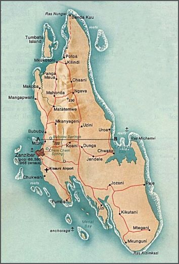
English: Map of Unguja island (Zanzibar Island) and its islets — in the Zanzibar Archipelago of the Indian Ocean, Tanzania.
- Unguja is the archipelago's southern main island.
- Pemba Island is the archipelago's northern main island, and its largest.
- Credits
- Wikipedia: from w:en:Image:Zanzibar (tanzania).jpg
.jpg)
- Univ. of Texas: from: http://www.lib.utexas.edu/maps/tanzania.html — "Map of Zanzibar Island, the southern main island of Zanzibar (Tanzania)"
- Extracted from: Zanzibar and Pemba Islands map[1], marked: "From Indian Ocean Atlas, CIA 1976"
![[1]](http://www.lib.utexas.edu/maps/islands_oceans_poles/zanzibar_island_76.jpg)
 |
تاريخ الملف
اضغط على زمن/تاريخ لرؤية الملف كما بدا في هذا الزمن.
| زمن/تاريخ | صورة مصغرة | الأبعاد | مستخدم | تعليق | |
|---|---|---|---|---|---|
| حالي | ★ مراجعة معتمدة 11:43، 8 ديسمبر 2023 | | 354 × 522 (44 كيلوبايت) | Pastakhov (نقاش | مساهمات) | Upload https://upload.wikimedia.org/wikipedia/commons/0/0b/Zanzibar_%28tanzania%29.jpg |
لا يمكنك استبدال هذا الملف.
وصلات
لا يوجد صفحات تصل لهذه الصورة.
.jpg&oldid=3726427)