ملف:Zanj Rebellion.svg

حجم معاينة PNG لذلك الملف ذي الامتداد SVG: 750 × 600 بكسل. البعد الآخر: 2٬560 × 2٬048 بكسل.
الملف الأصلي (ملف SVG، أبعاده 900 × 720 بكسل، حجم الملف: 1٫2 ميجابايت)
وصف قصير
| ⧼wm-license-information-description⧽ |
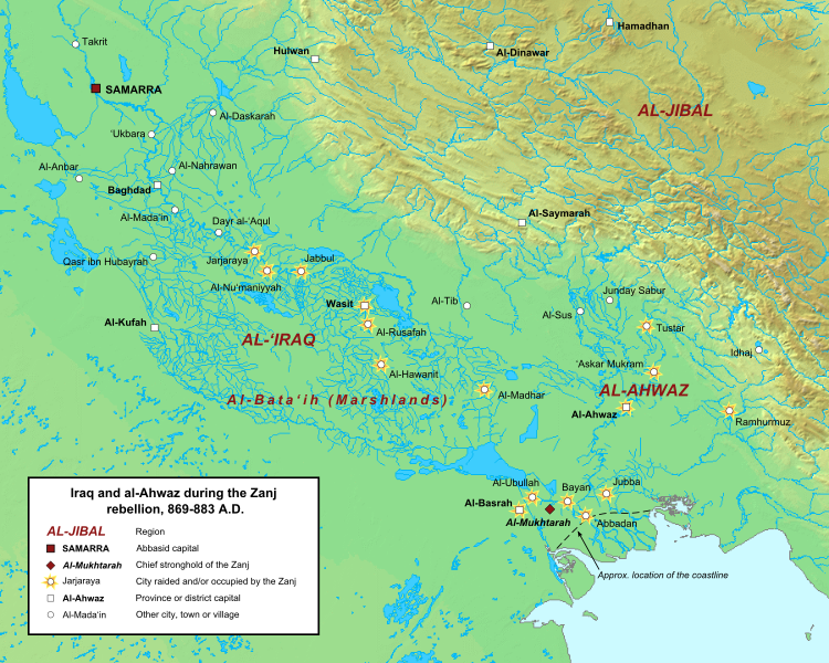
English: Map of the central Abbasid caliphate during the rebellion of the Zanj, from 869 to 883 A.D. All settlements on this map are listed by al-Tabari in his History of the Prophets and Kings, trans. "The History of al-Tabari," volumes 35 through 37. The location of cities and towns that no longer exist were determined using the maps of Le Strange and Popovic in their respective works.
Background topography taken from DEMIS Mapserver, which are public domain. Works Cited:
|
| ⧼wm-license-information-date⧽ | 2013, {{time}} – invalid date format 55 (help) |
| ⧼wm-license-information-source⧽ | ⧼Wm-license-own-work⧽ |
| ⧼wm-license-information-author⧽ | Ro4444 |
ترخيص
|
تاريخ الملف
اضغط على زمن/تاريخ لرؤية الملف كما بدا في هذا الزمن.
| زمن/تاريخ | صورة مصغرة | الأبعاد | مستخدم | تعليق | |
|---|---|---|---|---|---|
| حالي | ★ مراجعة معتمدة 11:24، 1 ديسمبر 2023 | | 900 × 720 (1٫2 ميجابايت) | Pastakhov (نقاش | مساهمات) | Upload https://upload.wikimedia.org/wikipedia/commons/a/a9/Zanj_Rebellion.svg |
لا يمكنك استبدال هذا الملف.
وصلات
لا يوجد صفحات تصل لهذه الصورة.