ملف:York Road station, Belfast (2) - geograph.org.uk - 995115.jpg
لا توجد دقة أعلى متوفرة.
York_Road_station,_Belfast_(2)_-_geograph.org.uk_-_995115.jpg (640 × 409 بكسل حجم الملف: 77 كيلوبايت، نوع MIME: image/jpeg)
وصف قصير
| ⧼wm-license-information-description⧽ |
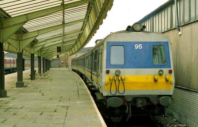
English: York Road station, Belfast (2)
York Road station opened in 1848. It served most of Cos Antrim, Londonderry and part of Tyrone. It was almost destroyed by the Luftwaffe. Its importance declined along with that of railways generally. Damaged several times during the bombing campaign in Belfast, it was reduced in status by the diversion of Londonderry/Portrush trains (via Antrim and Lisburn) to Belfast Central in 1978. When the photo was taken it served only Larne line trains. Work was then underway on the new cross-harbour line 4750. See also 498060. Continue to 1756636. The station closed the following year to be replaced by the adjacent Yorkgate 345632 and was subsequently demolished. The train is the 10.00 to Whitehead. Note: the Google map is completely awry - the positioning was made using the 1980 OSNI 1:10,000 Belfast street map. |
| ⧼wm-license-information-date⧽ | 1991 |
| ⧼wm-license-information-source⧽ | From geograph.org.uk |
| ⧼wm-license-information-author⧽ | Albert Bridge |
| ⧼wm-license-cc-attribution⧽ (قالب:I18n/Credit line) |
Albert Bridge / York Road station, Belfast (2) / |
_-_geograph.org.uk_-_1756636.jpg&action=edit&redlink=1)
54°36′44″N 5°55′21″W / 54.61215°N 5.9226°W قالب:Object location
_-_geograph.org.uk_-_995115.jpg¶ms=54.61215_N_5.9226_W_source:geograph-irishgrid(J34267575)_heading:180)
ترخيص
تاريخ الملف
اضغط على زمن/تاريخ لرؤية الملف كما بدا في هذا الزمن.
| زمن/تاريخ | صورة مصغرة | الأبعاد | مستخدم | تعليق | |
|---|---|---|---|---|---|
| حالي | ★ مراجعة معتمدة 01:03، 8 أكتوبر 2023 | | 640 × 409 (77 كيلوبايت) | Pastakhov (نقاش | مساهمات) | Upload https://upload.wikimedia.org/wikipedia/commons/d/d0/York_Road_station%2C_Belfast_%282%29_-_geograph.org.uk_-_995115.jpg |
لا يمكنك استبدال هذا الملف.
وصلات
لا يوجد صفحات تصل لهذه الصورة.
_-_geograph.org.uk_-_995115.jpg&oldid=3026240)