ملف:Wpdms shdrlfi020l owens valley.jpg
لا توجد دقة أعلى متوفرة.
Wpdms_shdrlfi020l_owens_valley.jpg (300 × 300 بكسل حجم الملف: 56 كيلوبايت، نوع MIME: image/jpeg)
وصف قصير
| ⧼wm-license-information-description⧽ |
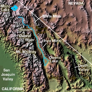
English: Topographic relief map of Owens Valley and Owens River, the Sierra Nevada, and the White Mountains in California — and a portion of the western Great Basin region in Nevada.
|
| ⧼wm-license-information-date⧽ | قالب:Original upload date |
| ⧼wm-license-information-source⧽ | Transferred from en.wikipedia |
| ⧼wm-license-information-author⧽ | Original uploader was Decumanus at en.wikipedia |
| ⧼wm-license-information-permission⧽ (⧼wm-license-information-permission-reusing-text⧽) |
CC-BY-SA-3.0-MIGRATED; GFDL-WITH-DISCLAIMERS; Released under the GNU Free Documentation License. |
ترخيص
قالب:GFDL-en قالب:GFDL-with-disclaimers
قالب:Original upload log
قالب:Original description page
- 2004-06-27 23:24 Decumanus 300×300× (57616 bytes) [[Owens Valley]] © 2004 Matthew Trump {{GFDL}}
تاريخ الملف
اضغط على زمن/تاريخ لرؤية الملف كما بدا في هذا الزمن.
| زمن/تاريخ | صورة مصغرة | الأبعاد | مستخدم | تعليق | |
|---|---|---|---|---|---|
| حالي | ★ مراجعة معتمدة 06:50، 31 أكتوبر 2023 | | 300 × 300 (56 كيلوبايت) | Pastakhov (نقاش | مساهمات) | Upload https://upload.wikimedia.org/wikipedia/commons/7/75/Wpdms_shdrlfi020l_owens_valley.jpg |
لا يمكنك استبدال هذا الملف.
وصلات
لا يوجد صفحات تصل لهذه الصورة.