ملف:Waterfall Road - geograph.org.uk - 1512157.jpg
لا توجد دقة أعلى متوفرة.
Waterfall_Road_-_geograph.org.uk_-_1512157.jpg (640 × 413 بكسل حجم الملف: 214 كيلوبايت، نوع MIME: image/jpeg)
وصف قصير
| ⧼wm-license-information-description⧽ |
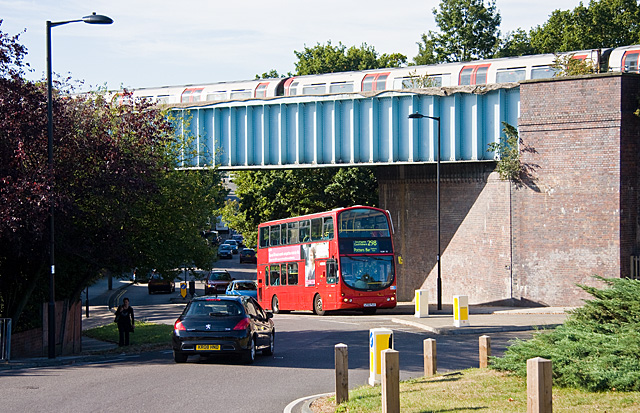
English: Waterfall Road, near to Southgate, Enfield, Great Britain.
Seen here at the roundabout where it meets with Hampden Way and Morton Way. VLW50 on the 298 route to Potters Bar has just passed under the Piccadilly Line whilst a southbound train can be seen passing over the viaduct. The 298 is normally a single deck route, so this is presumably a school/rush hour run, though it could equally be a substitute for a vehicle that has gone 'mechanical' - broken down.
|
| ⧼wm-license-information-date⧽ | 2009 |
| ⧼wm-license-information-source⧽ | From geograph.org.uk; transferred by User:oxyman using geograph_org2commons. |
| ⧼wm-license-information-author⧽ | Martin Addison |
| ⧼wm-license-information-permission⧽ (⧼wm-license-information-permission-reusing-text⧽) |
Creative Commons Attribution Share-alike license 2.0 |
| ⧼wm-license-cc-attribution⧽ (قالب:I18n/Credit line) |
Martin Addison / Waterfall Road / |
قالب:Location dec قالب:Object location
ترخيص
تاريخ الملف
اضغط على زمن/تاريخ لرؤية الملف كما بدا في هذا الزمن.
| زمن/تاريخ | صورة مصغرة | الأبعاد | مستخدم | تعليق | |
|---|---|---|---|---|---|
| حالي | ★ مراجعة معتمدة 19:34، 24 أكتوبر 2023 | | 640 × 413 (214 كيلوبايت) | Pastakhov (نقاش | مساهمات) | Upload https://upload.wikimedia.org/wikipedia/commons/7/78/Waterfall_Road_-_geograph.org.uk_-_1512157.jpg |
لا يمكنك استبدال هذا الملف.
وصلات
لا يوجد صفحات تصل لهذه الصورة.