ملف:View down Gipsy Hill - geograph.org.uk - 1778304.jpg
لا توجد دقة أعلى متوفرة.
View_down_Gipsy_Hill_-_geograph.org.uk_-_1778304.jpg (640 × 481 بكسل حجم الملف: 127 كيلوبايت، نوع MIME: image/jpeg)
وصف قصير
| ⧼wm-license-information-description⧽ |
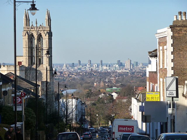
English: View down Gipsy Hill One of the highest points in London so excellent vistas can be glimpsed between almost any two buildings or at any corner you turn in this area.
The tower on the left used to belong to Christ Church (1867, by John Giles), but is now a private residence after the remainder of the original church was destroyed by fire in 1982 (since rebuilt). Grade II listed. The prominent buildings in the middle-distance, above the green building, are those of Dulwich College. In the background a number of prominent buildings in the City are visible. To the left of the church is the dome of St Paul's Cathedral. To its right can be seen the three Barbican towers - Cromwell, Shakespeare, and Lauderdale (1965-76, Chamberlin, Powell and Bon). To the right the distinctive concrete tower is that of Guy's Hospital, the tallest hospital building in the world (1974, Watkins Gray). |
| ⧼wm-license-information-date⧽ | 2010 |
| ⧼wm-license-information-source⧽ | From geograph.org.uk |
| ⧼wm-license-information-author⧽ | Stephen Richards |
| ⧼wm-license-cc-attribution⧽ (قالب:I18n/Credit line) |
Stephen Richards / View down Gipsy Hill / |
51°25′12″N 0°04′58″W / 51.42012°N 0.0828°W قالب:Object location
_heading:337)
ترخيص
تاريخ الملف
اضغط على زمن/تاريخ لرؤية الملف كما بدا في هذا الزمن.
| زمن/تاريخ | صورة مصغرة | الأبعاد | مستخدم | تعليق | |
|---|---|---|---|---|---|
| حالي | ★ مراجعة معتمدة 05:29، 25 أكتوبر 2023 | | 640 × 481 (127 كيلوبايت) | Pastakhov (نقاش | مساهمات) | Upload https://upload.wikimedia.org/wikipedia/commons/3/3a/View_down_Gipsy_Hill_-_geograph.org.uk_-_1778304.jpg |
لا يمكنك استبدال هذا الملف.
وصلات
لا يوجد صفحات تصل لهذه الصورة.