ملف:The Jewish cemetery, Hoop Lane - geograph.org.uk - 676609.jpg
لا توجد دقة أعلى متوفرة.
The_Jewish_cemetery,_Hoop_Lane_-_geograph.org.uk_-_676609.jpg (640 × 480 بكسل حجم الملف: 82 كيلوبايت، نوع MIME: image/jpeg)
وصف قصير
| ⧼wm-license-information-description⧽ |
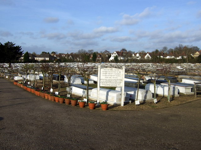
English: The Jewish cemetery, Hoop Lane The Jewish cemetery here was opened in 1897, a few years before the Crematorium which stands across the road. The West London Synagogue of British Jews and the Spanish and Portuguese Jews' Congregation own the cemetery and the grounds are physically divided in two, so that the graves and prayer halls for each congregation are separate: the Sephardic on the right (here) and the Ashkenazi on the left hand side.
The sign here is the Hebrew prayer to be said upon entering a cemetery.
|
| ⧼wm-license-information-date⧽ | 2008 |
| ⧼wm-license-information-source⧽ | From geograph.org.uk |
| ⧼wm-license-information-author⧽ | ceridwen |
| ⧼wm-license-cc-attribution⧽ (قالب:I18n/Credit line) |
ceridwen / The Jewish cemetery, Hoop Lane / |
51°34′41″N 0°11′39″W / 51.57809°N 0.1942°W قالب:Object location
_heading:0)
ترخيص
تاريخ الملف
اضغط على زمن/تاريخ لرؤية الملف كما بدا في هذا الزمن.
| زمن/تاريخ | صورة مصغرة | الأبعاد | مستخدم | تعليق | |
|---|---|---|---|---|---|
| حالي | ★ مراجعة معتمدة 10:36، 27 نوفمبر 2023 | | 640 × 480 (82 كيلوبايت) | Pastakhov (نقاش | مساهمات) | Upload https://upload.wikimedia.org/wikipedia/commons/9/9a/The_Jewish_cemetery%2C_Hoop_Lane_-_geograph.org.uk_-_676609.jpg |
لا يمكنك استبدال هذا الملف.
وصلات
لا يوجد صفحات تصل لهذه الصورة.