ملف:Rockwall County Texas Incorporated Areas Heath highlighted.svg

حجم معاينة PNG لذلك الملف ذي الامتداد SVG: 800 × 419 بكسل. البعد الآخر: 2٬560 × 1٬341 بكسل.
الملف الأصلي (ملف SVG، أبعاده 1٬050 × 550 بكسل، حجم الملف: 160 كيلوبايت)
وصف قصير
| ⧼wm-license-information-description⧽ |
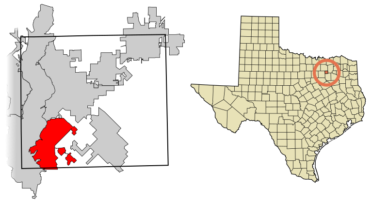
This map shows the incorporated areas in Rockwall County, Texas. Heath is highlighted in red. I created it in Inkscape using data from the following links: North Central Texas Council of Governments Maps Website, City of Rockwall Land Use Plan Map (PDF) |
| ⧼wm-license-information-date⧽ | 2007 |
| ⧼wm-license-information-source⧽ | My own work, based on government information. Though I strove to be as accurate in the detail as possible, the information shown is not guaranteed to be completely accurate. |
| ⧼wm-license-information-author⧽ | Ixnayonthetimmay |
| ⧼wm-license-information-permission⧽ (⧼wm-license-information-permission-reusing-text⧽) |
Public Domain |
| ⧼wm-license-information-other-versions⧽ |
See Category:Maps of Rockwall County, Texas for other versions of this image. |
ترخيص
تاريخ الملف
اضغط على زمن/تاريخ لرؤية الملف كما بدا في هذا الزمن.
| زمن/تاريخ | صورة مصغرة | الأبعاد | مستخدم | تعليق | |
|---|---|---|---|---|---|
| حالي | ★ مراجعة معتمدة 01:52، 11 أكتوبر 2023 | | 1٬050 × 550 (160 كيلوبايت) | Pastakhov (نقاش | مساهمات) | Upload https://upload.wikimedia.org/wikipedia/commons/3/33/Rockwall_County_Texas_Incorporated_Areas_Heath_highlighted.svg |
لا يمكنك استبدال هذا الملف.
وصلات
لا يوجد صفحات تصل لهذه الصورة.