ملف:Ptolemaeus Magna Germania.jpg

حجم هذه المعاينة: 800 × 575 بكسل. البعدان الآخران: 2٬560 × 1٬840 بكسل | 5٬440 × 3٬909 بكسل.
الملف الأصلي (5٬440 × 3٬909 بكسل حجم الملف: 27٫13 ميجابايت، نوع MIME: image/jpeg)
وصف قصير
| ⧼wm-license-information-description⧽ |
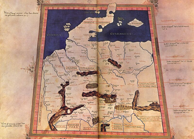
English: The 4th Map of Europe from Ptolemy's Geography, depicting Germany. Deutsch: EVROPA TABVLA QVARTA – Quarta Europe Tabula continet Germaniam cum insulis sibi adiacentibus. Die Karte zu Magna Germania aus der im Original griechisch verfaßten Geographike Hyphegesis des in Alexandria wirkenden Claudius Ptolemäus (*um 100; † um 175). Spätmittelalterliche Kopie des 15. Jahrhunderts die unter dem Titel Cosmographia erschien. Ptolemäus soll zwischen 125 und 151 tätig gewesen sein. Viele Wissenschaftler gehen davon aus, daß das Kartenwerk entweder vollständig oder zumindest teilweise in späterer Zeit auf der Grundlage des ptolemäischen Textes rekonstruiert worden ist. Der Codex Latinus V F.32 liegt in der Nationalbibliothek Neapel. Das Kartenwerk wird dem in Italien tätigen Deutschen Nicolaus Germanus zugeschrieben.
|
| ⧼wm-license-information-date⧽ | 15. Jahrhundert/31. Oktober 2009 |
| ⧼wm-license-information-source⧽ | ⧼Wm-license-own-work⧽ |
| ⧼wm-license-information-author⧽ |
|
| ⧼wm-license-information-other-versions⧽ |


ترخيص
تاريخ الملف
اضغط على زمن/تاريخ لرؤية الملف كما بدا في هذا الزمن.
| زمن/تاريخ | صورة مصغرة | الأبعاد | مستخدم | تعليق | |
|---|---|---|---|---|---|
| حالي | ★ مراجعة معتمدة 23:30، 10 نوفمبر 2023 | | 5٬440 × 3٬909 (27٫13 ميجابايت) | Pastakhov (نقاش | مساهمات) | Upload https://upload.wikimedia.org/wikipedia/commons/9/9d/Ptolemaeus_Magna_Germania.jpg |
لا يمكنك استبدال هذا الملف.
وصلات
لا يوجد صفحات تصل لهذه الصورة.