ملف:Price-Hill-Cincinnati-map.jpg

حجم هذه المعاينة: 800 × 507 بكسل. البعد الآخر: 1٬332 × 844 بكسل.
الملف الأصلي (1٬332 × 844 بكسل حجم الملف: 413 كيلوبايت، نوع MIME: image/jpeg)
وصف قصير
| ⧼wm-license-information-description⧽ |
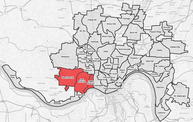
English: A map of the neighborhoods of Price Hill within Cincinnati, Ohio. Neighborhood lines are based on information from http://www.cincinnati-oh.gov/police/pages/-5095-/. This street map is derived from a free http://www.openstreetmap.org/ map.
|
||
| ⧼wm-license-information-date⧽ | 2008 | ||
| ⧼wm-license-information-source⧽ | ⧼Wm-license-own-work⧽ | ||
| ⧼wm-license-information-author⧽ | Wholtone | ||
| ⧼wm-license-information-permission⧽ (⧼wm-license-information-permission-reusing-text⧽) |
|
ترخيص
تاريخ الملف
اضغط على زمن/تاريخ لرؤية الملف كما بدا في هذا الزمن.
| زمن/تاريخ | صورة مصغرة | الأبعاد | مستخدم | تعليق | |
|---|---|---|---|---|---|
| حالي | ★ مراجعة معتمدة 02:34، 14 أكتوبر 2023 | | 1٬332 × 844 (413 كيلوبايت) | Pastakhov (نقاش | مساهمات) | Upload https://upload.wikimedia.org/wikipedia/commons/2/2a/Price-Hill-Cincinnati-map.jpg |
لا يمكنك استبدال هذا الملف.
وصلات
لا يوجد صفحات تصل لهذه الصورة.