ملف:Political map of the Solomon Islands archipelago in 1989.jpg
الملف الأصلي (748 × 650 بكسل حجم الملف: 72 كيلوبايت، نوع MIME: image/jpeg)

|
[All images in this gallery should be recreated using vector graphics as an SVG file. This has several advantages; see Commons:Media for cleanup for more information. If an SVG form of this image is already available, please upload it. After uploading an SVG, replace this template with {{vector version available|new image name.svg}}.] Error: {{Lang}}: text has italic markup (help) |
|
العربية | български | català | čeština | dansk | Deutsch | English | Esperanto | español | français | galego | 한국어 | italiano | magyar | lietuvių | 日本語 | Plattdüütsch | Nederlands | norsk | polski | português | română | русский | suomi | svenska | Türkçe | українська | 中文(繁體) | 中文(简体) | +/− | |
وصف قصير
| ⧼wm-license-information-description⧽ |
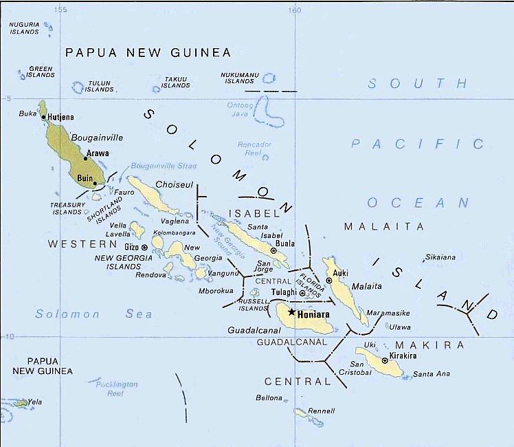
English: Solomon Islands map, modified and cropped from PCL map collection Courtesy of the University of Texas Libraries, The University of Texas at Austin.
According to the University of Texas, "most of the maps scanned by the University of Texas Libraries and served from this web site are in the public domain. No permissions are needed to copy them. You may download them and use them as you wish. A few maps are copyrighted, and are clearly marked as such.". As the image, when downloaded from here was no tagged, the map is PD. For a small map of the Solomon Islands, see: Image:SolomonIslandsMap.png Note that provincial borders are pre-1995; Rennell and Bellona has separated from Central Province, and Choiseul Province has separated from Western Province. Originally uploaded to En-Wikipedia by Darwinek on 13:39, 29 December 2004. |
| ⧼wm-license-information-date⧽ | 1989 |
| ⧼wm-license-information-source⧽ | Modified version of Solomon Islands (Political) 1989 from Perry-Castañeda Library Map Collection: Solomon Islands Maps. |
| ⧼wm-license-information-author⧽ | U.S. Central Intelligence Agency |
| ⧼wm-license-information-permission⧽ (⧼wm-license-information-permission-reusing-text⧽) |
Public domain |
| ⧼wm-license-information-other-versions⧽ |
ترخيص
 |
تاريخ الملف
اضغط على زمن/تاريخ لرؤية الملف كما بدا في هذا الزمن.
| زمن/تاريخ | صورة مصغرة | الأبعاد | مستخدم | تعليق | |
|---|---|---|---|---|---|
| حالي | ★ مراجعة معتمدة 19:36، 13 نوفمبر 2023 | | 748 × 650 (72 كيلوبايت) | Pastakhov (نقاش | مساهمات) | Upload https://upload.wikimedia.org/wikipedia/commons/4/45/Political_map_of_the_Solomon_Islands_archipelago_in_1989.jpg |
لا يمكنك استبدال هذا الملف.
وصلات
لا يوجد صفحات تصل لهذه الصورة.