ملف:Passchendaele aerial view.jpg

حجم هذه المعاينة: 445 × 600 بكسل. البعد الآخر: 500 × 674 بكسل.
الملف الأصلي (500 × 674 بكسل حجم الملف: 317 كيلوبايت، نوع MIME: image/jpeg)
|
| ⧼wm-license-information-description⧽ |
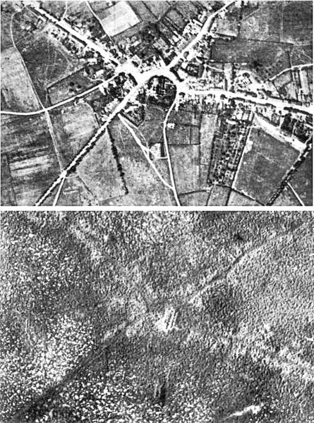
English: Aerial view of the village of Passchendaele (north is to the right of the photo) before and after the Third Battle of Ypres, 1917.
Français : Vue aerienne du village de Passendale, avant et après la troisième bataille d'Ypres, en 1917. Le nord est à droite sur les photos.
|
| ⧼wm-license-information-date⧽ | 1917 |
| ⧼wm-license-information-source⧽ | قالب:IWM Collections |
| ⧼wm-license-information-author⧽ | Photographer not identified. "Official photograph". |
| ⧼wm-license-information-permission⧽ (⧼wm-license-information-permission-reusing-text⧽) |
|
| ⧼wm-license-information-other-versions⧽ |
|
تاريخ الملف
اضغط على زمن/تاريخ لرؤية الملف كما بدا في هذا الزمن.
| زمن/تاريخ | صورة مصغرة | الأبعاد | مستخدم | تعليق | |
|---|---|---|---|---|---|
| حالي | ★ مراجعة معتمدة 04:41، 25 أكتوبر 2023 | | 500 × 674 (317 كيلوبايت) | Pastakhov (نقاش | مساهمات) | Upload https://upload.wikimedia.org/wikipedia/commons/c/c8/Passchendaele_aerial_view.jpg |
لا يمكنك استبدال هذا الملف.
وصلات
لا يوجد صفحات تصل لهذه الصورة.