ملف:Oeraals verspreiding-af.svg

حجم معاينة PNG لذلك الملف ذي الامتداد SVG: 800 × 547 بكسل. البعد الآخر: 2٬560 × 1٬751 بكسل.
الملف الأصلي (ملف SVG، أبعاده 1٬966 × 1٬345 بكسل، حجم الملف: 1٫85 ميجابايت)
| ⧼wm-license-information-description⧽ |
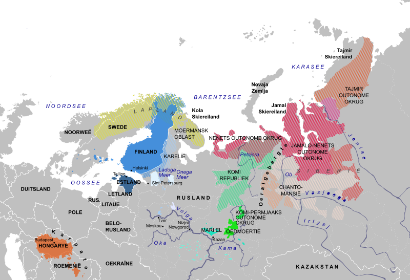
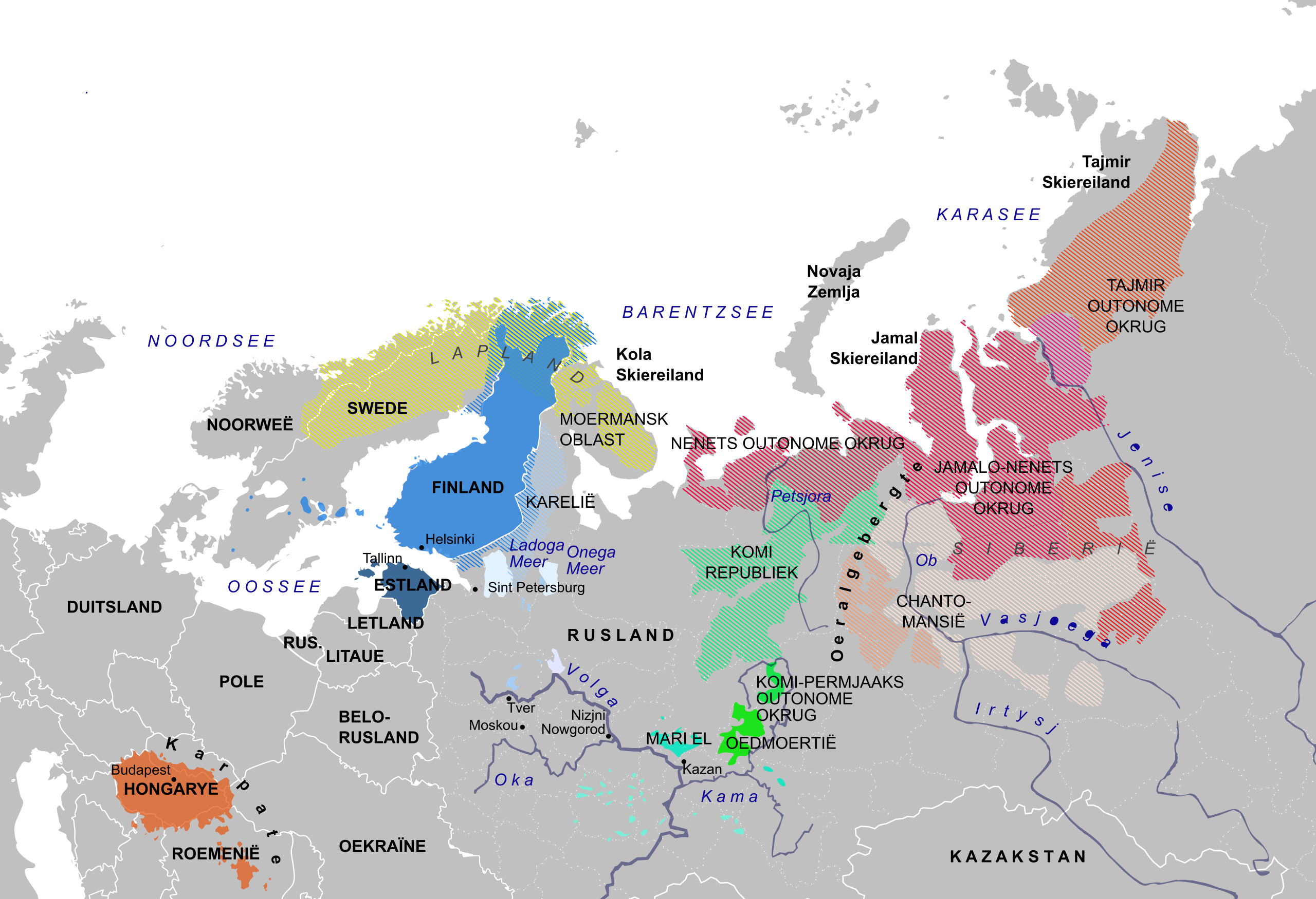
English: Linguistic map indicating the distribution of the Uralic languages قالب:Af
|
| ⧼wm-license-information-date⧽ | 2009-02-21 14:22 (UTC) |
| ⧼wm-license-information-source⧽ | English: own work derived from: قالب:Af
English: and enhanced based on additional information from International Northern Sea Route Programme) Working Paper No. 90 in 1997 (Nenets, Enets, Ngagasan and Sami in Russia as well as northern parts of Komi and Komi-Sirjeens
قالب:Af
|
| ⧼wm-license-information-author⧽ | Laurens |
| ⧼wm-license-information-permission⧽ (⧼wm-license-information-permission-reusing-text⧽) |
|
| ⧼wm-license-information-other-versions⧽ |
| [This is a retouched picture, which means that it has been digitally altered from its original version. Modifications: Constructed linguistic map of Uralic languages based on existing free maps and additional published information. The original can be viewed here: Sami_languages_large_2.png. Modifications made by Laurens.] Error: {{Lang}}: text has italic markup (help)
|

|
قالب:Original upload log
This image is a derivative work of the following images:
- File:Russia_locator_name.svg licensed with PD-self
- 2008-10-26T18:57:43Z SeNeKa 1092x630 (295256 Bytes) {{Information |Description={{en|1=aaa}} |Source=Own work by uploader |Author=[[User:SeNeKa|SeNeKa]] |Date= |Permission= |other_versions= }}
- File:Dist_of_hu_lang_europe.svg licensed with Cc-by-sa-3.0,2.5,2.0,1.0, GFDL
- 2008-04-04T20:44:35Z Mutichou 688x438 (148322 Bytes) {{Information |Description={{en|Hungarian speakers in Eastern Europe.}} |Source=[[:Image:Dist of hu lang europe.png|Dist of hu lang europe.png]] |Date=4 April 2008 |Author= [[User:Mutichou|Mutichou]] |Permission= |other_versi
- File:Finnish_language_map,_detailed_areas.png licensed with GFDL
- 2008-08-08T15:10:40Z BetacommandBot 911x752 (37349 Bytes) move approved by: [[User:Samulili]] This image was moved from [[:Image:Image language map, detailed areas.png]] {{Information |Description=Map of the areas where the Finnish language is spoken. |Source=*[[:Image:FinnishLang
- File:Sami_languages_large_2.png licensed with GFDL-en
- 2008-03-13T09:45:48Z Koryakov Yuri 1107x1329 (331626 Bytes) The original map had an error, including a municipality in the "official language zone" erroneously. Original is at http://en.wikipedia.org/wiki/Image:Corrected_sami_map_II.PNG
- 2007-05-31T17:19:28Z Jon Harald Søby 1107x1329 (329201 Bytes) {{Information |Description=Map of Fennoscandinavia showing the distribution of Sami languages, based on [[:Image:Sami languages large.png]] |Source=Originally uploaded to the [[:en:Image:Sami languages large 2.png|English Wik
تاريخ الملف
اضغط على زمن/تاريخ لرؤية الملف كما بدا في هذا الزمن.
| زمن/تاريخ | صورة مصغرة | الأبعاد | مستخدم | تعليق | |
|---|---|---|---|---|---|
| حالي | ★ مراجعة معتمدة 15:13، 10 نوفمبر 2023 | | 1٬966 × 1٬345 (1٫85 ميجابايت) | Pastakhov (نقاش | مساهمات) | Upload https://upload.wikimedia.org/wikipedia/commons/3/30/Oeraals_verspreiding-af.svg |
لا يمكنك استبدال هذا الملف.
وصلات
لا يوجد صفحات تصل لهذه الصورة.