ملف:Oakland California aerial view.jpg

حجم هذه المعاينة: 800 × 533 بكسل. البعد الآخر: 1٬500 × 1٬000 بكسل.
الملف الأصلي (1٬500 × 1٬000 بكسل حجم الملف: 884 كيلوبايت، نوع MIME: image/jpeg)
| ⧼wm-license-information-description⧽ |
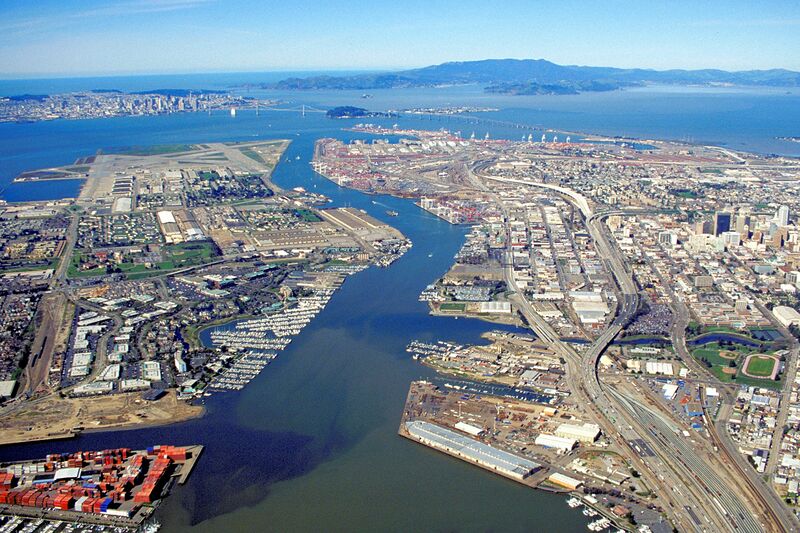
English: Aerial view of the port of Oakland, California, USA. The city of San Francisco is clearly visible at top left. The Bay Bridge runs across the the top of the picture, and the Golden Gate Bridge can be seen. The runways of the former Alameda Naval Air Station can be seen at left. Downtown Oakland appears at the far right. View is to the west-northwest.
Coordinates: |
||||
| ⧼wm-license-information-date⧽ | not specified or unknown, but some time before 1995, as the Wind River complex between Alaska Basin and the Encinal Yacht Club is shown as a vacant lot | ||||
| ⧼wm-license-information-source⧽ | U.S. Army Corps of Engineers Digital Visual Library Image page Image description page Digital Visual Library home page |
||||
| ⧼wm-license-information-author⧽ | Robert Campbell | ||||
| ⧼wm-license-information-permission⧽ (⧼wm-license-information-permission-reusing-text⧽) |
|
||||
| قالب:Location/i18n | Oakland, California, USA |

تاريخ الملف
اضغط على زمن/تاريخ لرؤية الملف كما بدا في هذا الزمن.
| زمن/تاريخ | صورة مصغرة | الأبعاد | مستخدم | تعليق | |
|---|---|---|---|---|---|
| حالي | ★ مراجعة معتمدة 16:25، 20 أكتوبر 2023 | | 1٬500 × 1٬000 (884 كيلوبايت) | Pastakhov (نقاش | مساهمات) | Upload https://upload.wikimedia.org/wikipedia/commons/6/6c/Oakland_California_aerial_view.jpg |
لا يمكنك استبدال هذا الملف.
وصلات
لا يوجد صفحات تصل لهذه الصورة.