ملف:NCO Map.png
لا توجد دقة أعلى متوفرة.
NCO_Map.png (251 × 289 بكسل حجم الملف: 7 كيلوبايت، نوع MIME: image/png)

|
[All images in this gallery should be recreated using vector graphics as an SVG file. This has several advantages; see Commons:Media for cleanup for more information. If an SVG form of this image is already available, please upload it. After uploading an SVG, replace this template with {{vector version available|new image name.svg}}.] Error: {{Lang}}: text has italic markup (help) |
|
العربية | български | català | čeština | dansk | Deutsch | English | Esperanto | español | français | galego | 한국어 | italiano | magyar | lietuvių | 日本語 | Plattdüütsch | Nederlands | norsk | polski | português | română | русский | suomi | svenska | Türkçe | українська | 中文(繁體) | 中文(简体) | +/− | |
وصف قصير
| ⧼wm-license-information-description⧽ |
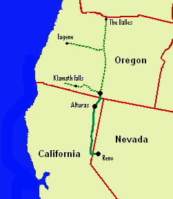
English: Map of Nevada-California-Oregon Railroad line
|
| ⧼wm-license-information-date⧽ | 2008 |
| ⧼wm-license-information-source⧽ | ⧼Wm-license-own-work⧽ |
| ⧼wm-license-information-author⧽ | Orygun (talk) |
ترخيص
قالب:Original upload log
قالب:Transferred from قالب:Original description page
- 2008-01-07 01:01 Orygun 251×289× (7398 bytes) {{Information |Description=Map of Nevada-California-Oregon Railroad line |Source=self-made from basic map already in Wikipedia Commons |Date=6 January 2008 |Location= |Author= |Permission= |other_versions= }}
- 2008-01-07 00:59 Orygun 251×289× (7398 bytes) {{Information |Description=Map of Nevada-California-Oregon Railroad line |Source=self-made from basic map already in Wikipedia Commons |Date=6 January 2008 |Location= |Author= |Permission= |other_versions= }}
تاريخ الملف
اضغط على زمن/تاريخ لرؤية الملف كما بدا في هذا الزمن.
| زمن/تاريخ | صورة مصغرة | الأبعاد | مستخدم | تعليق | |
|---|---|---|---|---|---|
| حالي | ★ مراجعة معتمدة 07:57، 27 نوفمبر 2023 | | 251 × 289 (7 كيلوبايت) | Pastakhov (نقاش | مساهمات) | Upload https://upload.wikimedia.org/wikipedia/commons/c/cb/NCO_Map.png |
لا يمكنك استبدال هذا الملف.
وصلات
لا يوجد صفحات تصل لهذه الصورة.