ملف:Mapa Set Riberetes-La Valiella.jpg
لا توجد دقة أعلى متوفرة.
Mapa_Set_Riberetes-La_Valiella.jpg (410 × 410 بكسل حجم الملف: 79 كيلوبايت، نوع MIME: image/jpeg)
وصف قصير
| ⧼wm-license-information-description⧽ |
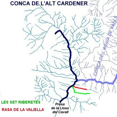
Català: Mapa de la conca alta del Cardener (Vall de Lord, Solsonès) en el qual hi apareixen destacades la Rasa de la Valiella i Les Set Riberetes.
|
| ⧼wm-license-information-date⧽ | 2013, {{time}} – invalid date format 48 (help) |
| ⧼wm-license-information-source⧽ | ⧼Wm-license-own-work⧽ |
| ⧼wm-license-information-author⧽ | Isidre blanc.Autor de l'original Capolatell |
قالب:Object location dec قالب:Derived from de l'autor Capolatell
ترخيص
|
تاريخ الملف
اضغط على زمن/تاريخ لرؤية الملف كما بدا في هذا الزمن.
| زمن/تاريخ | صورة مصغرة | الأبعاد | مستخدم | تعليق | |
|---|---|---|---|---|---|
| حالي | ★ مراجعة معتمدة 01:13، 14 أكتوبر 2023 | | 410 × 410 (79 كيلوبايت) | Pastakhov (نقاش | مساهمات) | Upload https://upload.wikimedia.org/wikipedia/commons/1/1d/Mapa_Set_Riberetes-La_Valiella.jpg |
لا يمكنك استبدال هذا الملف.
وصلات
لا يوجد صفحات تصل لهذه الصورة.