ملف:Little Laramie River 1905.jpg
لا توجد دقة أعلى متوفرة.
Little_Laramie_River_1905.jpg (700 × 427 بكسل حجم الملف: 185 كيلوبايت، نوع MIME: image/jpeg)
| ⧼wm-license-information-description⧽ |
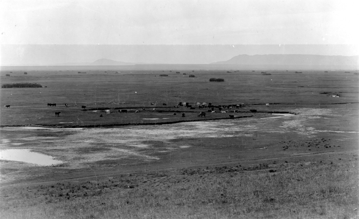
English: Laramie Plains looking southwest from ridge 2 miles north of Mandel, Little Laramie river in the foreground, Sheep Mountain to left of center. Albany County. 1905. Figure 4 in U.S. Geological Survey. Folio 173. 1910. Folio-0017
Digital File:dnh01135 ID. Darton, N.H. 1135 Original found at Original found at [1] using keywords "Little," "Laramie]]and "River." |
| ⧼wm-license-information-date⧽ | |
| ⧼wm-license-information-source⧽ | USGS |
| ⧼wm-license-information-author⧽ | USGS |
ترخيص
This image is a work of a United States Geological Survey employee, taken or made during the course of the person's official duties. As a work of the United States Government, the image is in the public domain. For more information, see the USGS copyright policy.
قالب:Original upload log
قالب:Original description page
- 2006-11-21 00:12 Cuppysfriend 700×427× (188931 bytes) Laramie Plains looking southwest from ridge 2 miles north of Mandel, [[Little Laramie river]] in the foreground, Sheep Mountain to left of center. [[Albany County, Wyoming]]. [[1905]]. Figure 4 in U.S. Geological Survey. Folio 173. 1910. Folio-0017 Digi
تاريخ الملف
اضغط على زمن/تاريخ لرؤية الملف كما بدا في هذا الزمن.
| زمن/تاريخ | صورة مصغرة | الأبعاد | مستخدم | تعليق | |
|---|---|---|---|---|---|
| حالي | ★ مراجعة معتمدة 03:22، 27 يناير 2024 | | 700 × 427 (185 كيلوبايت) | Pastakhov (نقاش | مساهمات) | Upload https://upload.wikimedia.org/wikipedia/commons/8/86/Little_Laramie_River_1905.jpg |
لا يمكنك استبدال هذا الملف.
وصلات
لا يوجد صفحات تصل لهذه الصورة.