ملف:Lau Basin-NOAA-Tectonic features hires.jpg

الملف الأصلي (2٬642 × 2٬189 بكسل حجم الملف: 4٫65 ميجابايت، نوع MIME: image/jpeg)
وصف قصير
| ⧼wm-license-information-description⧽ |
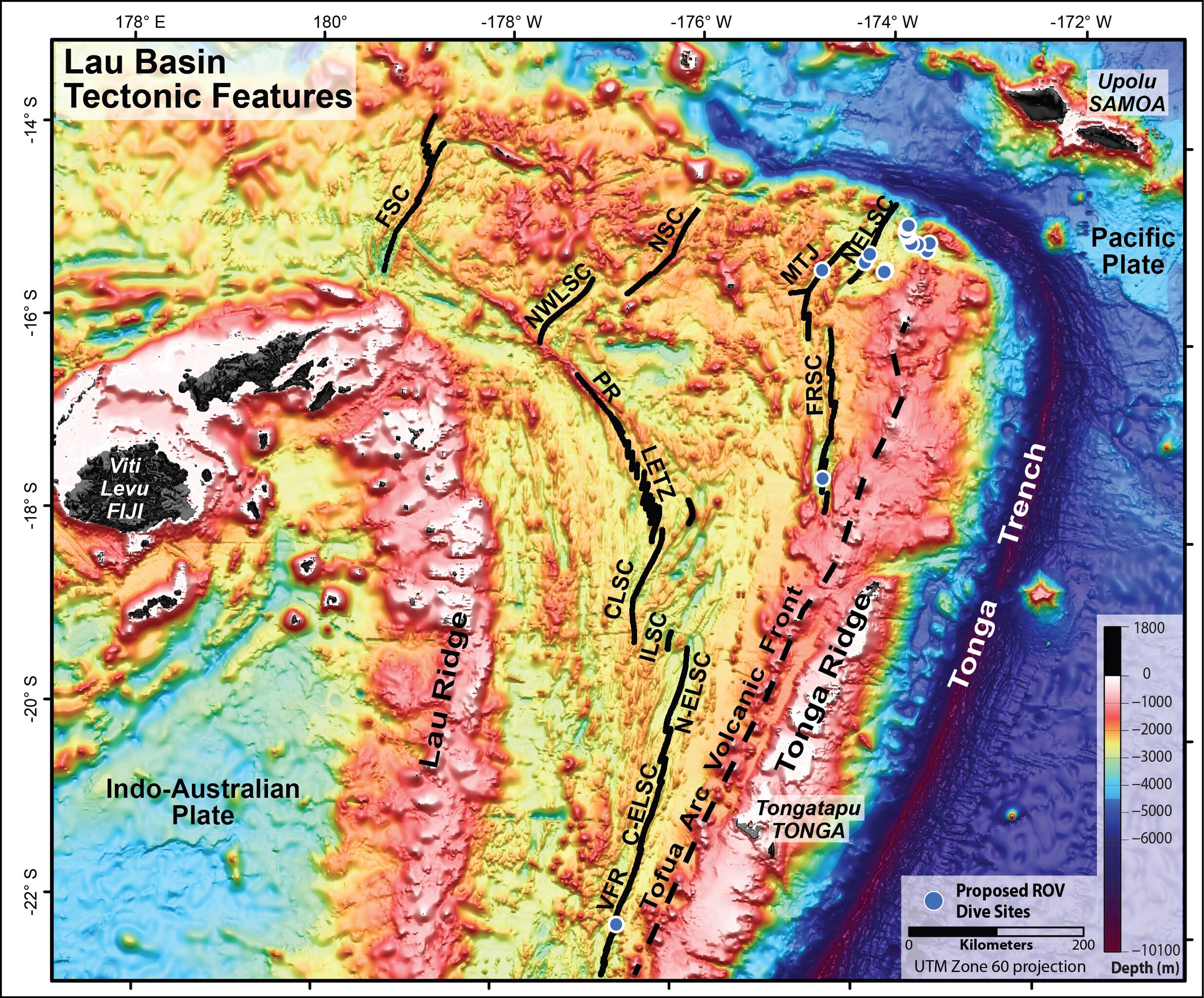
Tectonic map of the Lau Basin. Tectonic features of the Lau Basin overlaid on satellite altimetry data, modified from Martinez and Taylor Geophysical Monograph 166, 2006. The Spreading centers and ridges are shown with black solid lines: Valu Fa Ridge (VFR), Central Eastern Lau Spreading Center (C-ELSC), Intermediate Lau Spreading Center (ILSC), Central Lau Spreading Center (CLSC), Lau Extensional Transform Zone (LETZ), Peggy Ridge (PR), North-West Lau Spreading Center (NWLSC), Niuafo’ou Spreading Center (NSC), Futuna Spreading Center (FSC), Mangatolu Triple Junction (MTJ), Fonualei Rift and Spreading Center (FRSC), North-East Lau Spreading Center (NELSC). Tonga trench, ridges and tectonic plates are also noted. Image courtesy of NOAA Vents Program. |
| ⧼wm-license-information-date⧽ | 2012 |
| ⧼wm-license-information-source⧽ | NOAA Ocean Explorer |
| ⧼wm-license-information-author⧽ | NOAA Vents Program |
| ⧼wm-license-information-permission⧽ (⧼wm-license-information-permission-reusing-text⧽) |
NOAA encourages users to maintain the "metadata with this image and properly credit the image as identified in the metadata and on the page which links to this image." |
| ⧼wm-license-information-other-versions⧽ |
ترخيص

|
تاريخ الملف
اضغط على زمن/تاريخ لرؤية الملف كما بدا في هذا الزمن.
| زمن/تاريخ | صورة مصغرة | الأبعاد | مستخدم | تعليق | |
|---|---|---|---|---|---|
| حالي | ★ مراجعة معتمدة 16:09، 9 نوفمبر 2023 | | 2٬642 × 2٬189 (4٫65 ميجابايت) | Pastakhov (نقاش | مساهمات) | Upload https://upload.wikimedia.org/wikipedia/commons/a/ae/Lau_Basin-NOAA-Tectonic_features_hires.jpg |
لا يمكنك استبدال هذا الملف.
وصلات
لا يوجد صفحات تصل لهذه الصورة.