ملف:Kom Ombo map.png
Kom_Ombo_map.png (447 × 546 بكسل حجم الملف: 127 كيلوبايت، نوع MIME: image/png)
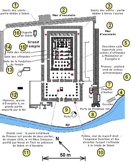
Opis schematu świątyni w Kom Ombo – The Description on the Plan of the Temple Complex at Kom Ombo :
1)Święty Świętych (sanktuarium Sobka) – The Sanctuary of Sobek
2)Mur otaczający kompleks – The Wall surrounding
3)Święty Świętych (sanktuarium Horusa Starszego) – The Sanctuary of Haroeris
4)Schody – The Staircase
5)Sala Hypostylowa – The Hypostyle hall
6)Pronaos
7)Kaplica Hathor – The Chapel of Hathor
8)Brama Ptolemeusza XII Auletesa– The Gate of Ptolemy XII Auletes
9)Studnia – The Well
10)Pylon
11)Wielki Dziedziniec z ołtarzem – The Great Court with the Altar
12)Mammisi (Dom Urodzin Boga-Dziecka) – Mammisi (Birth House)
13)Sala Fundacji Świątyni – Hall of the Temple's Fundation
14)Sala Ofiar – Hall of victims
15)Sala Posągów – Hall of statues
16)Kaplica Sobeka – The Chapel of Sobek
Description
The Plan of the Temple Complex at Kom Ombo.
Plan de Kôm Ombo.
Plan świątyni w Kom Ombo.
Licence
Source
Drawing by Gérard Ducher (french version) and Janmad (desciption for english and polish version)
Dessin de Gérard Ducher et Janmad.
Wykonane przez Gérarda Duchera (francuska wersja) i Janmada (opis do angielskiej i polskiej wersji).
تاريخ الملف
اضغط على زمن/تاريخ لرؤية الملف كما بدا في هذا الزمن.
| زمن/تاريخ | صورة مصغرة | الأبعاد | مستخدم | تعليق | |
|---|---|---|---|---|---|
| حالي | 16:53، 7 يناير 2009 | | 447 × 546 (127 كيلوبايت) | Nadia Ahmed (نقاش | مساهمات) |
لا يمكنك استبدال هذا الملف.
وصلات
لا يوجد صفحات تصل لهذه الصورة.