ملف:Karte NordWestBahn 2016.svg

حجم معاينة PNG لذلك الملف ذي الامتداد SVG: 557 × 599 بكسل. البعد الآخر: 1٬903 × 2٬048 بكسل.
الملف الأصلي (ملف SVG، أبعاده 1٬232 × 1٬326 بكسل، حجم الملف: 4٫86 ميجابايت)
وصف قصير
| ⧼wm-license-information-description⧽ |
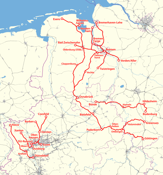
Deutsch: Karte der 2016 von der NordWestBahn betriebenen Strecken
English: Map of the routes operated by NordWestBahn in 2016
|
| ⧼wm-license-information-date⧽ | 2015 |
| ⧼wm-license-information-source⧽ | ⧼Wm-license-own-work⧽ using File:Karte NordWestBahn 2012.svg |
| ⧼wm-license-information-author⧽ | NordNordWest |
| ⧼wm-license-information-other-versions⧽ |
|
ترخيص
تاريخ الملف
اضغط على زمن/تاريخ لرؤية الملف كما بدا في هذا الزمن.
| زمن/تاريخ | صورة مصغرة | الأبعاد | مستخدم | تعليق | |
|---|---|---|---|---|---|
| حالي | ★ مراجعة معتمدة 05:30، 25 أكتوبر 2023 | | 1٬232 × 1٬326 (4٫86 ميجابايت) | Pastakhov (نقاش | مساهمات) | Upload https://upload.wikimedia.org/wikipedia/commons/3/37/Karte_NordWestBahn_2016.svg |
لا يمكنك استبدال هذا الملف.
وصلات
لا يوجد صفحات تصل لهذه الصورة.