ملف:Godavari satellite view.jpg

حجم هذه المعاينة: 600 × 600 بكسل. البعدان الآخران: 2٬048 × 2٬048 بكسل | 5٬248 × 5٬248 بكسل.
الملف الأصلي (5٬248 × 5٬248 بكسل حجم الملف: 8٫05 ميجابايت، نوع MIME: image/jpeg)
وصف قصير
| ⧼wm-license-information-description⧽ |
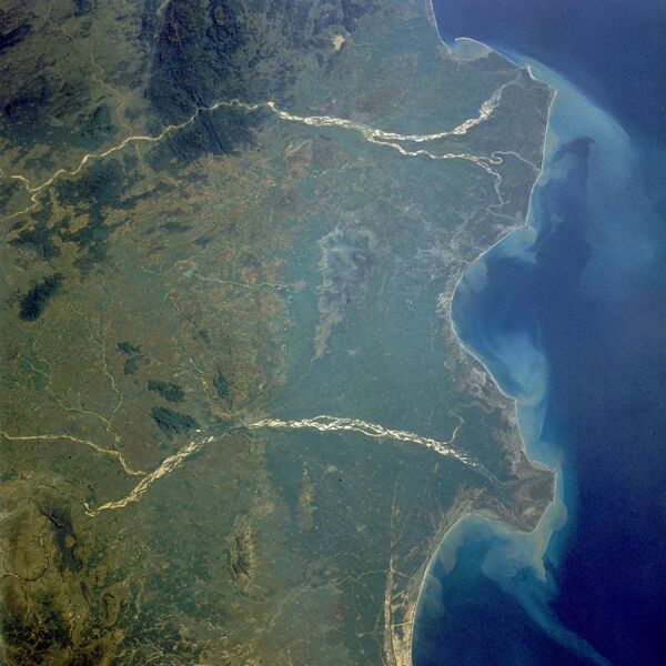
Français : les deltas de la Godavari et de la Krishna.
English: Godavari and Krishna River Deltas in South India — the mouths of the Godavari River (northeast; upper in image) and the Krishna River (southwest, lower in image) empty into the Bay of Bengal in this low-oblique, northwest-looking photograph (October 1989).
|
| ⧼wm-license-information-date⧽ | 1989 |
| ⧼wm-license-information-source⧽ | http://earth.jsc.nasa.gov/scripts/sseop/photo.pl?mission=STS034&roll=77&frame=29 |
| ⧼wm-license-information-author⧽ | Earth Sciences and Image Analysis, NASA-Johnson Space Center. 16 Sep. 2004. "Earth from Space" |
ترخيص
قالب:Original upload log
قالب:Original description page
- 2004-09-19 21:40 Nataraja 640×640× (131443 bytes) les deltas de la Godâvarî et de la Krishnâ
تاريخ الملف
اضغط على زمن/تاريخ لرؤية الملف كما بدا في هذا الزمن.
| زمن/تاريخ | صورة مصغرة | الأبعاد | مستخدم | تعليق | |
|---|---|---|---|---|---|
| حالي | ★ مراجعة معتمدة 00:29، 3 ديسمبر 2023 | | 5٬248 × 5٬248 (8٫05 ميجابايت) | Pastakhov (نقاش | مساهمات) | Upload https://upload.wikimedia.org/wikipedia/commons/d/d8/Godavari_satellite_view.jpg |
لا يمكنك استبدال هذا الملف.
وصلات
لا يوجد صفحات تصل لهذه الصورة.