ملف:Frisco system map circa 1901.jpg

الملف الأصلي (800 × 1٬170 بكسل حجم الملف: 364 كيلوبايت، نوع MIME: image/jpeg)
وصف قصير
| ⧼wm-license-information-description⧽ |
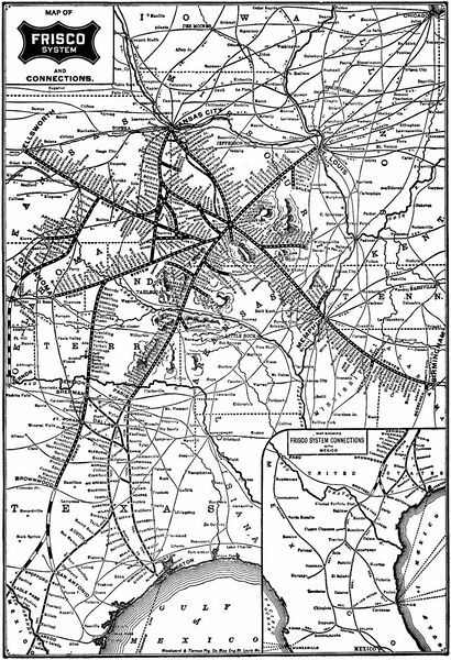
System map of the Frisco lines (St. Louis-San Francisco Railway), probably published by the railroad itself. No date or copyright notice given, but must have been made between 1901 when Frisco acquired the w:Fort Worth and Rio Grande Railway between Ft. Worth and Brownwood, Texas, and before 1903 when Frisco began building an extension to Brady and Menard (shown as Menardville on this map). Also, w:Gulf Coast Lines route from Houston to Brownsville, begun 1903, is not shown. Thus, map is over 100 years old and should be in the public domain. Found at Catskill Archive, http://www.tshaonline.org/handbook/online/articles/eqf10 |
| ⧼wm-license-information-date⧽ | |
| ⧼wm-license-information-source⧽ | |
| ⧼wm-license-information-author⧽ |
ترخيص
قالب:Original upload log
قالب:Original description page
| زمن/تاريخ | الأبعاد | مستخدم | تعليق |
|---|---|---|---|
| 2011-04-06 01:00:31 | 800× 1170× | Textorus | System map of the Frisco lines (St. Louis-San Francisco Railway), probably published by the railroad itself. No date or copyright notice given, but must have been made between 1901 when Frisco acquired the [[Fort Worth and Rio Grande Railway]] between Ft |
تاريخ الملف
اضغط على زمن/تاريخ لرؤية الملف كما بدا في هذا الزمن.
| زمن/تاريخ | صورة مصغرة | الأبعاد | مستخدم | تعليق | |
|---|---|---|---|---|---|
| حالي | ★ مراجعة معتمدة 07:00، 9 ديسمبر 2023 | | 800 × 1٬170 (364 كيلوبايت) | Pastakhov (نقاش | مساهمات) | Upload https://upload.wikimedia.org/wikipedia/commons/5/54/Frisco_system_map_circa_1901.jpg |
لا يمكنك استبدال هذا الملف.
وصلات
لا يوجد صفحات تصل لهذه الصورة.